2020:762 - CLOONRADOON (3), Roscommon
County: Roscommon
Site name: CLOONRADOON (3)
Sites and Monuments Record No.: N/A
Licence number: E005199
Author: Lydia Cagney and Conn Herriott
Author/Organisation Address: AMS, Fahy's Road, Kilrush, Clare
Site type: Burnt mound and Structure
Period/Dating: Bronze Age (2200 BC-801 BC)
ITM: E 594895m, N 780962m
Latitude, Longitude (decimal degrees): 53.778214, -8.077452
Cloonradoon 3 consisted of a burnt mound with an adjacent stake-lined structure and preserved bark and timber remains. The site was discovered c.1.6km east of Strokestown, in advance of construction of the N5 Ballaghaderreen to Scramoge Road Project in County Roscommon by Archaeological Management Solutions Ltd (AMS) for Roscommon County Council (RCC) and Transport Infrastructure Ireland (TII). It was identified during Stage (i)a Standard Test Excavations, carried out by AMS (Ministerial Direction No. A077, Registration No. E5070; Hardy 2021).
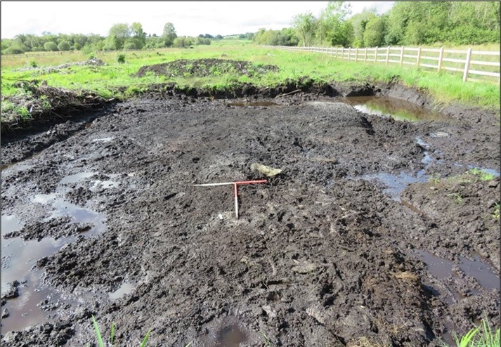
The on-site Stage (iii) Excavation Services at Cloonradoon 3 were undertaken by AMS between 19 August and 13 September 2020. The irregular burnt mound (11m north-north-east/south-south-west by 6.5m east–west and 0.62m deep) consisted of two layers of charcoal- and organic-rich sandy silt with frequent heat-shattered sandstone that overlay a peat layer which extended across the site. A halved tree trunk (2.8m by 2.6m in plan and 0.15m thick) was discovered between the lower layer of the burnt mound and the peat layer. Intercutting linear features, including one ditch and two drains, truncated the burnt mound.
An irregular, slightly sub-oval arrangement of 30 stakes, partially enclosing three overlapping tree-bark peels that had been laid in a shallow hollow in the peat, was located 0.4m southeast of the burnt mound. These tree-bark peels (combined measurement: 1.26m by 0.7m in plan and 0.05m thick) underlay a second peat layer (1.6m by 1.05m in plan and 0.19m deep) that was overlaid with a box-halved plank (0.36m by 0.05m in plan and 0.03m thick).
The preserved stakes were driven into this peat and the underlying bark peels, forming a feature that measured 1.4m by 0.83m in plan and 0.31m deep. Twenty-one stakes were set vertically and nine set at a 60–80° angle. Twenty of the stakes had worked ends (including eleven chisel points, five wedge points and four pencil points); most were whole roundwoods, but five were box-quartered. These may have formed part of a wickerwork structure, where rods would have been woven horizontally between the stakes. Two larger stakes were placed at either end of the structure (0.15m by 0.11m and 0.5m thick and 0.19m by 0.08m and 0.06m thick), each with a multi-faceted pencil point and possible tool- and rope-marks.
The stake-lined feature was underlying a layer of sand (1.1m by 0.9m in plan and 0.09m deep) which was overlaid by a second box-halved plank of wood (0.62m by 0.23m in plan and 0.03m thick).
No artefacts were recovered from Cloonradoon 3; however, 39 samples were retrieved including three bulk soil samples, one lipid sample and 35 wood samples.
While the burnt mound is presently undated, it may be indicative of prehistoric subsistence and/or other specialised activities. Post-excavation analysis has commenced, and it is hoped that specialist reports and radiocarbon dating will further the interpretation of the site.
Reference
Hardy, C. 2021. N5 Ballaghaderreen to Scramoge Road Project Stage (i)a, (i)b, (i)c Test Excavation, Stage (i)m Testing in Felled Forestry and Stage (i)f Townland Boundary Survey. Ministerial Direction No. A077, Registration No. E5070. Unpublished AMS report for TII and RCC.