2020:760 - TULLEN (2), Roscommon
County: Roscommon
Site name: TULLEN (2)
Sites and Monuments Record No.: N/A
Licence number: E005142
Author: Lydia Cagney, Breana McCulloch and Kevin Kearney, AMS
Author/Organisation Address: Fahy's Road, Kilrush, Clare
Site type: Burnt spread, Pit and Cultivation ridges
Period/Dating: Multi-period
ITM: E 592666m, N 783386m
Latitude, Longitude (decimal degrees): 53.799971, -8.111327
Tullen 2 was located in pastureland approximately 2km northwest of Strokestown in County Roscommon. It was excavated in advance of construction of the N5 Ballaghaderreen to Scramoge Road Project by Archaeological Management Solutions (AMS) for Roscommon County Council (RCC) and Transport Infrastructure Ireland (TII). It was identified during Stage (i)i Geophysical Surveys under Ministerial Direction No. A077 and Registration No. R0509 by Target Archaeological Geophysics Ltd (Nicholls 2019) and subsequently targeted by Stage (i)a Test Excavations, carried out by AMS under Ministerial Direction (Direction No. A077, Registration No. E5070; Hardy 2021).
The site comprised four burnt spreads and associated features, distributed across four areas (A–D) in two cuttings, many of which were truncated by post-medieval ditches, furrows and drains. The on-site Stage (iii) Excavation Services at Tullen 2 were undertaken by AMS between 22 May and 2 July 2020.
Area A contained a sub-oval burnt spread (3.05m by 2.4m in plan and 0.09m deep) which covered a sub-oval trough (1.5m by 1m in plan and 0.4m deep) and six post-holes. The post-holes were situated along the eastern and south-western edges of the trough suggesting the presence of a possible light structure or windbreak. An additional eight post-holes, four pits and one small spread were found in close proximity to the burnt spread (beyond its extent). The pits were oval or sub-oval in plan and ranged in size from 0.84–2.5m long, 0.56–1.9m wide and 0.01–0.25m deep. Animal bone from large and medium-sized mammals and a number of fragments of calcined indeterminate bone were recovered from the fills of three of the pits.
Area B contained an irregular burnt spread (12.27m by 8.9m in plan and 0.14m deep); a sub-oval trough (2.07m by 1.46m in plan and 0.43m deep), an associated stake-hole and an intercutting pit and post-hole were located under its western side. Two pits (one of which was re-cut) and a sub-oval trough (1.7m by 1.42m in plan and 0.46m deep) were located under its eastern side. Hazel charcoal from one of the pits returned a Chalcolithic date of 2472–2297 cal. BC (UBA-47760; 3920±28BP) and a hazelnut shell from the basal fill of the re-cut pit returned a late medieval/post-medieval date of cal. AD 1503–1646 (UBA-47761; 308±21BP). Cow, sheep/goat and pig bones were recovered from the fills of the larger trough and one of the pits. A flint flake was recovered from the basal fill of the trough and a decorated rotary quern stone fragment was retrieved from the upper fill of the re-cut pit. Wheat and oats, charred hazelnuts and the waterlogged remains of brambles, knotweed, docks and campion were also recovered from the re-cut pit.
Area C contained a large irregular burnt spread (12.1m by 9.9m in plan and 0.12m deep) which covered or partially covered two sub-rectangular troughs, two possible wells, five pits, seven stake-holes, five post-holes and one spread. A sixth pit and additional small spread of burnt material were located to the southwest and southeast of the burnt spread. The small spread extended beyond the limit of excavation suggesting further features remain in situ beyond the Compulsory Purchase Order area.
Both of the troughs in Area C were likely lined. One had a post-hole in each corner and the other had a stake-hole in each corner. A fifth stake-hole at the centre of one of its short ends contained the preserved remains of a wooden stake and a partially preserved timber plank was lying lengthwise along its base. A sample of hazel charcoal from the basal fill of one of the troughs returned an Early to Middle Bronze Age date of 1882–1691 cal. BC (UBA-47758; 3462±28BP), while a sample of hazel charcoal from the fill of one of the post-holes in the other trough returned a Late Bronze Age date of 1011–844 cal. BC (UBA-47759; 2793±25BP).
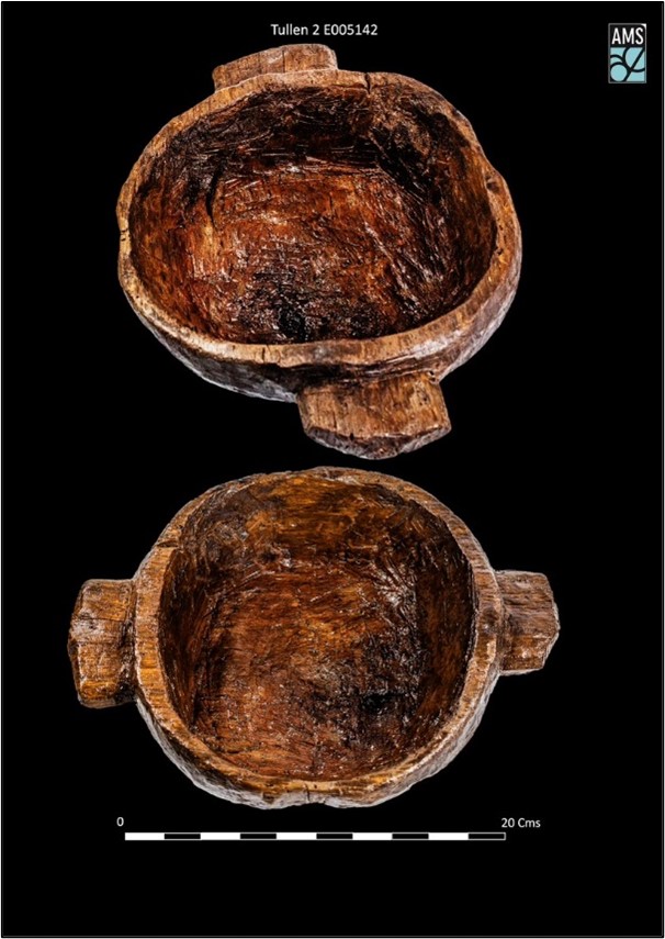
One of the wells (4.8m by 3.08m in plan and 1.81m deep) had a gently sloping north-east side which may have acted as an entry point and was re-cut at least two times. A sample of hazel charcoal from the basal fill of this well returned a Late Bronze Age date of 1256–1019 cal. BC (UBA-47762; 2938±29BP). The second re-cut had a piece of wattle on its base—that may have been part of a lining—and a wooden bowl. The alder bowl was hewn rather than turned and was dated to the Iron Age (196 cal. BC–cal. AD 6 (UBA-43858; 2086+32BP)). The other well (1.4m by 0.8m in plan with a minimum depth of 1.58m), which was too deep to be fully excavated, had large sub-angular stones and boulders embedded into the sides and two preserved stakes within its fills, one of which bore clear tool marks.
Organic residue (lipid) analysis from a sample of stone from the fill of one of the pits suggests the presence of vegetation-derived organic matter of a woody origin, possibly roots found in soil. A pig premolar, long bones from a medium-sized animal and indeterminate calcined fragments of long bone were also recovered from the fills of the troughs and pits, while a sub-oval hammerstone was recovered near the base of the main burnt spread in Area C.
Area D contained an irregular burnt spread (4.45m by 2.9m in plan and 0.09m deep) which covered a sub-rectangular trough (1.95m by 1.3m in plan and 0.2m deep). A sub-oval trough (1.5m by 1m in plan and 0.14m deep) and a pit were located to the southeast and a small sub-oval spread and patch of burnt mound material were located further to the east.
Post-medieval and modern agricultural features were also recorded at Tullen 2, including four ditches, nine furrows and one modern drain.
Overall, eight artefacts were recovered from Tullen 2 including a fragment of decorated rotary quern stone, four clay-pipe stems, the wooden bowl, a hammerstone and a flint flake. Charcoal from the burnt spreads, troughs and pits consisted of hazel, ash, oak, elm, blackthorn/cherry, pomaceous fruitwood, ivy and willow. Archaeobotanical remains comprised hedgerow species, raspberry, blackberry, elder and sloe, in addition to wheat, oats and ruderal taxa such as docks and knotweed.
This report summary was submitted on behalf of its authors.
References
Hardy, C. 2021. N5 Ballaghaderreen to Scramoge Road Project Stage (i)a, (i)b, (i)c Test Excavation, Stage (i)m Testing in Felled Forestry and Stage (i)f Townland Boundary Survey. Ministerial Direction No. A077, Registration No. E5070. Unpublished AMS report for TII and RCC.
Nicholls, J. 2019. Geophysical Survey Report N5 Ballaghaderreen to Scramoge Road Project, County Roscommon. Unpublished report by Target Archaeological Geophysics GCV for AMS and RCC.