2020:751 - KILDALLOGE (1), Roscommon
County: Roscommon
Site name: KILDALLOGE (1)
Sites and Monuments Record No.: N/A
Licence number: E005223
Author: Gerry Mullins and Brigid Melloy, AMS
Author/Organisation Address: Fahy's Road, Kilrush, Clare
Site type: House - vernacular house
Period/Dating: Modern (AD 1750-AD 2000)
ITM: E 593708m, N 782023m
Latitude, Longitude (decimal degrees): 53.787736, -8.095482
Kildalloge 1 was excavated in advance of construction of the N5 Ballaghaderreen to Scramoge Road Project in County Roscommon by Archaeological Management Solutions (AMS) for Roscommon County Council (RCC) and Transport Infrastructure Ireland (TII). The site consisted of the partial remains of a vernacular structure. A structure is indicated on the first-edition six-inch Ordnance Survey (OS) map (1838) and two structures are indicated on the 25-inch OS map (1914). The site was recorded in the Environmental Impact Assessment Report as part of CHC61: the site of eight buildings (Roughan & O’Donovan-AECOM 2017, 326). Partial structural remains were subsequently identified during the Stage (i)e Built Heritage Survey (Campbell & McNamara 2022, 82–3).
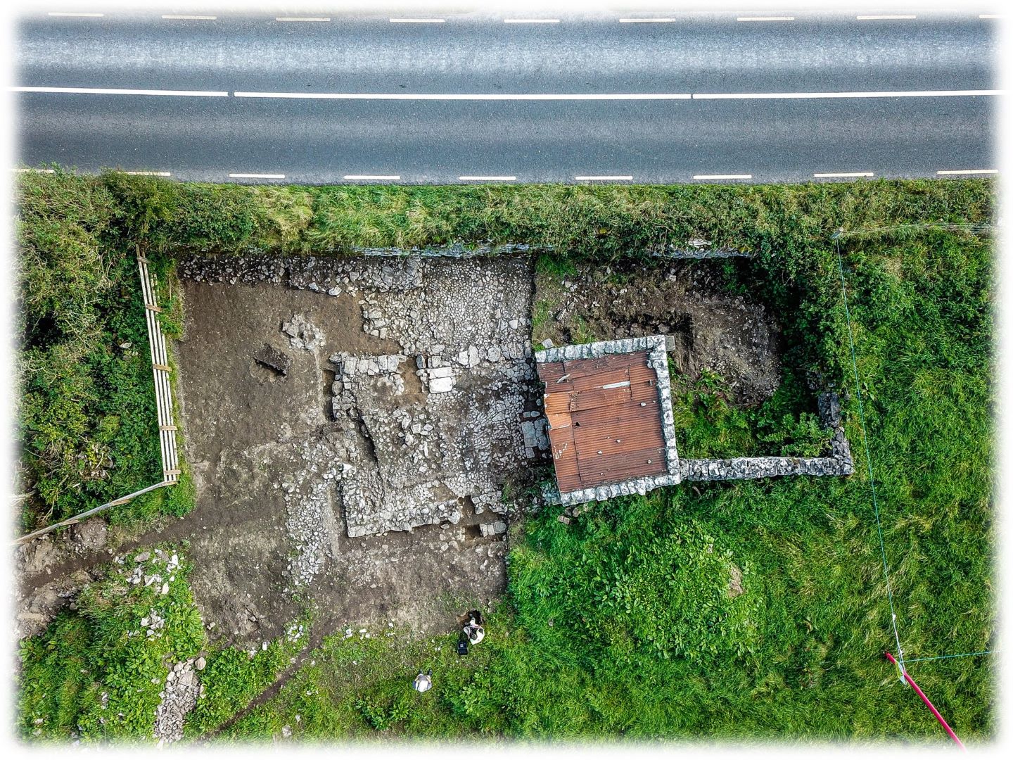
The main feature identified during the excavation was a two-room house. The south-west third of the house was upstanding and had been converted into a shed (ibid., 82–3). It comprised the sections of the south-west wall, parts of the north-west and south-east walls and its north-east wall originally formed the hearth wall of the house. The excavation uncovered the wall footings and floor layers of the demolished north-eastern two-thirds of the building. The remains of the house were defined by a foundation trench (C.5) and three continuous sections of wall (C.4). A hearth (C.13) was identified abutting the hearth wall, while an entrance (C.12) was identified in the south-east-facing wall and a cobbled surface (C.18) was found in the interior. The building was slightly trapezoidal in plan, widening by 0.8m to the northeast. It measured 11.4m (northeast–southwest) by 4.8–5.6m externally, and the excavated section was 7m (northeast–southwest) by 4–4.2m. The upstanding shed which represented the south-west room of the house measured 3.74–3.84m (northwest–southeast) by 2.95m–3.32m (ibid., 82). The building appears to have had only two rooms: a larger kitchen occupying the north-east two-thirds with a smaller room in the southwest. The floor of the building was not fully revealed during the excavation, but no evidence for a division (walls or differential floor surfaces) was noted.
An external cobbled surface was identified to the southeast of the structure and comprised firmly compacted sub-rounded limestone cobbles which underlay a layer of redeposited subsoil. The cobbled surface and the layer of redeposited subsoil were cut by a stone-filled drain. Other drains were observed on the site. The site underlay two demolition layers from which 125 sherds of post-medieval pottery, 46 pieces of glass, 45 metal objects, 36 clay pipe fragments, three bone combs, three ivory combs, one horn comb/razor cover, one brick, four buttons and two decorated slates were recovered. This assemblage has been dated to the nineteenth–twentieth centuries, reflecting the general date of occupation. The finds represent a mixture of fine and ‘work-a-day’ items, including typical food processing and storage items, objects relating to everyday agricultural and domestic work, items of personal adornment and decorative objects for showing off around the home.
The structure was likely occupied from at least the mid–late nineteenth century, when Griffith’s Valuation (1857–58) records William Geraghty as occupier. By the 1901 census it appears that his two daughters, Margaret Mannion and Eliza Gerraghty, inhabited the structure at Kildalloge 1. They had moved by the time of the 1911 census, although it could not be determined if their former dwelling was subsequently abandoned or if it was occupied further into the early twentieth century.
This report summary was submitted on behalf of its authors.
References
Campbell, E. & McNamara, J. 2022. N5 Ballaghaderreen to Scramoge Road Project Stage (i)e Built Heritage Survey. Unpublished AMS report for TII and Roscommon County Council.
Roughan & O’Donovan-AECOM. 2017. N5 Ballaghaderreen to Scramoge Road Project Environmental Impact Assessment Report. TII and Roscommon National Road Design Office. Available at: https://www.pleanala.ie/publicaccess/EIAR-NIS/300493/Volume%202B%20EIAR%20Chapter%2011-19/00-EIAR%20(1).pdf. [Accessed 11 November 2021].