2020:750 - SCRAMOGE (1), Roscommon
County: Roscommon
Site name: SCRAMOGE (1)
Sites and Monuments Record No.: N/A
Licence number: E005168
Author: Gerry Mullins and Kevin Kearney, AMS
Author/Organisation Address: Fahy's Road, Kilrush, Clare
Site type: Burnt spread
Period/Dating: Bronze Age (2200 BC-801 BC)
ITM: E 595836m, N 779776m
Latitude, Longitude (decimal degrees): 53.767565, -8.063159
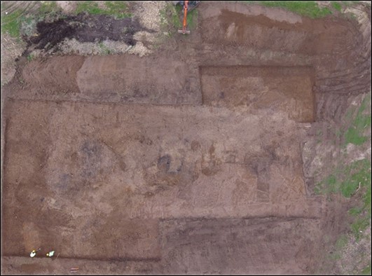
Scramoge 1 was excavated in advance of construction of the N5 Ballaghaderreen to Scramoge Road Project in County Roscommon by Archaeological Management Solutions (AMS) for Roscommon County Council (RCC) and Transport Infrastructure Ireland (TII). The site consisted of a patchy burnt spread, two pits and a sub-rectangular trough. It was identified during Stage (i)a Standard Test Excavations, carried out by AMS under Ministerial Direction (Direction No. A077, Registration No. E5070; Hardy 2021).
The trough had steep vertical sides that broke sharply at the top and gradually at the bottom to a flat base, and was 2.3m long, 1.8m wide and 0.47m deep. It had five stake-holes cut through its base—one in three of its corners and a pair in the fourth—and contained four successive fills. The stake-holes ranged from 0.05–0.16m in diameter, 0.13–0.22m in depth, all projected vertically and were filled by soft mid-grey gritty silt or silty sand containing charcoal. Their arrangement in the corners of the trough suggests that they once pinned a lining—perhaps of wooden planks—in place. Two indeterminate pieces of calcined mammal bone were recovered from the fill of one of the stake-holes in the trough.
The basal fill comprised firmly compacted greyish black charcoal-rich silty sand, 0.4m deep, containing heat-affected red sandstone and unshattered river-rolled stones. It is probably a remnant of the last use of the trough. The second fill comprised soft orangey-brown sandy silt, 0.22m deep, containing stones and occasional charcoal flecks, probably the result of natural silting after the trough went out of use. This was overlain by loosely compacted bluish-black silty sand containing heat-affected stones, charcoal and river-rolled stones; this is likely the remnants of previous trough uses that were piled beside it and was subsequently pushed or fell back into it. The uppermost fill was a compacted light yellowish-brown silty clay 0.11m deep. This is likely a mixture of natural silting and topsoil.
The two pits were located adjacent one another, c.15m south-southeast of the trough. The larger of the two (C.18) was sub-oval in plan and had gradually sloping sides that broke gradually at the top and imperceptibly at the bottom to a concave base. It was 2.55m long, 1.43m wide, 0.24m deep and contained a single fill: firmly compacted mottled bluish-black charcoal-rich silty sand and heat-affected stones. The other pit was irregularly shaped in plan, 0.71m long, 0.35m wide and 0.17m deep, and contained a fill identical to the larger pit.
Charcoal from the basal fill the trough, fill of the larger pit and the fill of one stake-hole consisted of elm, hazel and ash. A sample of hazel charcoal from the basal fill of the trough returned a Late Bronze Age date of 1211–1017 cal. BC (UBA-47753; 2919±29BP). No artefacts were found during the investigation.
This report was submitted on behalf of its authors.
Reference
Hardy, C. 2021. N5 Ballaghaderreen to Scramoge Road Project Stage (i)a, (i)b, (i)c Test Excavation, Stage (i)m Testing in Felled Forestry and Stage (i)f Townland Boundary Survey. Ministerial Direction No. A077, Registration No. E5070. Unpublished AMS report for TII and RCC.