2020:748 - KILDALLOGE (3), Roscommon
County: Roscommon
Site name: KILDALLOGE (3)
Sites and Monuments Record No.: N/A
Licence number: E005129
Author: Gerry Mullins and Kevin Kearney, AMS
Author/Organisation Address: Fahy's Road, Kilrush, Clare
Site type: Burnt mound
Period/Dating: Bronze Age (2200 BC-801 BC)
ITM: E 593368m, N 781687m
Latitude, Longitude (decimal degrees): 53.784712, -8.100635
Kildalloge 3 was excavated in advance of construction of the N5 Ballaghaderreen to Scramoge Road Project in County Roscommon by Archaeological Management Solutions (AMS) for Roscommon County Council (RCC) and Transport Infrastructure Ireland (TII). The site consisted of a burnt mound located in a field of pasture on the outskirts of Strokestown. It was initially identified during Stage (i)a Test Excavations, carried out by AMS under Ministerial Direction (Direction No. A077, Registration No. E5070; Hardy 2021).
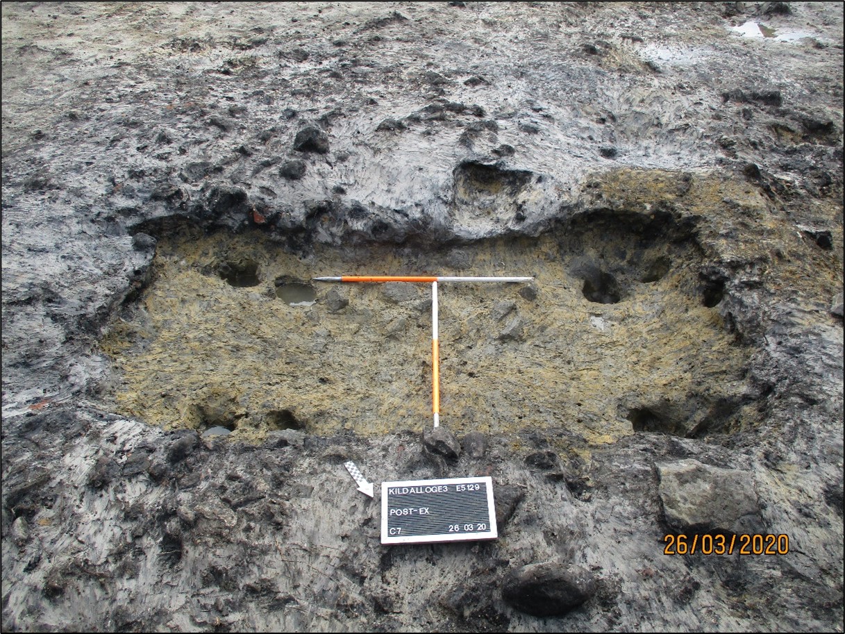
The burnt mound was composed of charcoal-rich silty clay and heat-shattered stone. It was c.14.5m by 10.5m in plan and 0.59m deep. It covered two pits, one of which (C.7) has been interpreted as a trough. The trough was sub-rectangular in plan, 2.9m long, 1.4m wide, 0.34m deep, and a pair of post- or stake-holes in each corner. A sample of hazel charcoal from one of the post-holes was dated to the Late Bronze Age, 1194–934 cal. BC (UBA-46767, 2880±28 BP). The other pit (C.8) was sub-circular in plan, 3.18m long, 2.75m wide and 0.79m deep. Fragments of burnt bone, including vertebra and a carpal/tarsal from an adult sheep/goat, were recorded in the basal fill and a sample of hazel charcoal from it was dated to the Late Bronze Age, 1012–858 cal. BC (UBA-46766, 2798±22BP).
Palaeo-environmental analysis identified a wide range of charred wood macro-remains, including hazel, oak, ash, elm, alder, willow, cherry/blackthorn, spindle and pomaceous fruit trees, indicating that the fuel for the burnt mound had been opportunistically collected from the local landscape which included wet and drier forests.
An incomplete retouched flint flake (E5129:1) was recovered from the burnt mound. Typologically it is likely to date from the Neolithic or Early Bronze Age, potentially millennia before the date of the burnt mound. However, it had evidently been broken—seemingly intentionally—long after its initial use and prior to its final deposition.
The report summary was submitted on behalf of its authors.
Reference
Hardy, C. 2021. N5 Ballaghaderreen to Scramoge Road Project Stage (i)a, (i)b, (i)c Test Excavation, Stage (i)m Testing in Felled Forestry and Stage (i)f Townland Boundary Survey. Ministerial Direction No. A077, Registration No. E5070. Unpublished AMS report for TII and RCC.