2020:744 - LAVALLY (2), Roscommon
County: Roscommon
Site name: LAVALLY (2)
Sites and Monuments Record No.: N/A
Licence number: A077; E5085
Author: Eve Campbell, Archaeological Management Solutions
Author/Organisation Address: Fahy's Road, Kilrush, Co. Clare
Site type: Fulacht fia, Enclosure and Pitfield
Period/Dating: Multi-period
ITM: E 594145m, N 781774m
Latitude, Longitude (decimal degrees): 53.785503, -8.088846
Lavally 2 was excavated in advance of construction of the N5 Ballaghaderreen to Scramoge Road Project in County Roscommon by AMS for Roscommon County Council and TII. This area was one of twelve sites or areas of potential that had already been identified through geophysical survey and/or testing carried out as part of the Environmental Impact Assessment (EIA) (Roughan & O’Donovan/AECOM 2017). Previous investigations undertaken at this location include geophysical survey and hand-auguring by Earthsound Archaeological Geophysics under licences 15R0123 and 15E0438 (Bonsall & Gimson 2016), and archaeological testing carried out by Archer Heritage Planning under licence 15E0589 (O’Connell 2016). The results of these investigations were summarised in Chapter 14 of the EIAR (Roughan & O’Donovan/AECOM 2017).
The geophysical survey at Lavally (GA11) detected ‘clear and coherent traces of pits in a known pit field’ as well as ‘a field system’ and ‘possible small enclosure features’ (Roughan & O’Donovan/AECOM 2017, chapter 14, 96). Test excavation at Lavally (AH05B/ AH98 EIAR) confirmed the presence of a levelled, disturbed burnt spread (AH101A), as well as the presence of ‘potential pits’ associated with the pitfield (O’Connell 2016, 19). A second burnt spread and a series of gullies and ditches, potentially related to the adjacent raths, were identified during Stage (ii) stripping by Gerry Mullins and Eve Campbell (AMS).
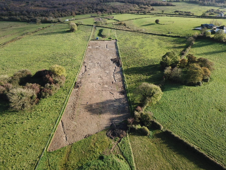
The on-site Stage (iii) Excavation Services at Lavally 2 were undertaken between 22 August and 13 November 2019. Additional excavation and recording of pitfield pits from the site was carried out by John Channing on 14–24 September 2020. The site of Lavally 2 consisted of two fulachtaí fia with associated troughs, likely Bronze Age in date; a series of gullies and ditches potentially associated with the adjacent raths; a number of pitfield pits of unclear date; and a sequence of later historic field drains, boundaries and ditches.
The western burnt spread (excavated area) measured c.22m long and 5.7m wide and extended beyond the limit of excavation. It was also truncated by a field drain on the western extent of the excavated portion of the spread. One sub-rectangular and one sub-oval trough, nine pits and two tree throws were underlying the burnt spread or located beyond its north-eastern extent. The troughs measured 2.27–3.42m long, 1.77m–2.94m wide and 0.28–0.86m deep. Four post-holes recorded along the inner corners of the sub-rectangular trough suggested the trough was lined. Charcoal from the fills of the troughs returned Late Bronze Age dates of 1115–930 cal. BC (UBA-47766; 2858±27BP) and 1013–839 cal. BC (UBA-47767; 2794±28BP). One of the nine associated pits had a depth of 0.92m and may have functioned as a cistern or well.
The eastern burnt spread measured 13.2m by 11.3m. Two intercutting troughs, eight pits and a post-hole were underlying the burnt spread. The sub-oval troughs measured 2.3m long, 1.49–2.03m wide and 0.21–0.63m deep. Charcoal from the fills of the troughs returned Early and Late Bronze Age dates of 2024–1782 cal. BC (UBA-47769; 3578±27BP) and 1213–1016 cal. BC (UBA-47768; 2919±28BP). An additional nine pits and a post-hole were also located across the site and may have also been associated with the burnt spreads.
A series of eight curvilinear ditches was also revealed running north-west/south-east and north-north-east/west-south-west across the full extent of the site. OSL dating of the fills of four of these returned dates of AD 1172–1452 (710±140; X7648), AD 532–992 (1260±230; X7649), 228 BC–AD 332 (1970±280; X7651) and 838 BC–AD 52 (2415±445).
Five pitfield pits measuring 3.3–10.76m long, 1.3–2m wide and 0.56–0.9m deep and c.14.5m long were also investigated. OSL dating of the fill of one returned a medieval date of AD 1067–1357 (810±145; X7652).
The artefacts found at Lavally 2 included flint and silicate flakes, a seventeenth-century iron horseshoe, eighteenth- to nineteenth-century glass, pottery sherds, clay pipe stems, copper-alloy button and an iron barbed wire. The flint and silicate flake, horseshoe, clay pipe stems and copper-alloy button will be retained for the national collection. Charcoal from the burnt spreads, troughs and pits consisted of hazel, alder, ash, oak, elm, blackthorn/cherry, pomaceous fruitwood, spindle, ivy and willow, while charred cereal grains and animal bone of sheep/goat, cow and indeterminate species were recovered from various features across the site.
References
Bonsall, J. & Gimson, H. 2016. Geophysical Survey Report, N5 Ballaghaderreen-Scramoge Road Development. Unpublished report prepared by Earthsound Archaeological Geophysics on behalf of Roscommon County Council.
O’Connell, A. 2016. N5 Ballaghaderreen-Scramoge Road Development, Archaeological Consultancy Services Contract, Stage (i) Services Area AH05; Lavally and Vesnoy, Co. Roscommon, Licence No. 15E0589. Unpublished report by Archer Heritage Planning for Roscommon County Council.
Roughan & O’Donovan/AECOM. 2017. N5 Ballaghaderreen to Scramoge Road Project Environmental Impact Assessment Report. TII and Roscommon National Road Design Office.