2020:741 - CREGGA (1), Roscommon
County: Roscommon
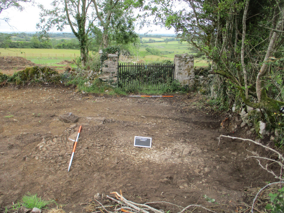
Site name: CREGGA (1)
Sites and Monuments Record No.: N/A
Licence number: A077 E5171
Author: Eve Campbell, Archaeological Management Solutions
Author/Organisation Address: Fahy's Road, Kilrush, Co. Clare
Site type: Road - road/trackway and Gate lodge
Period/Dating: Modern (AD 1750-AD 2000)
ITM: E 590850m, N 785587m
Latitude, Longitude (decimal degrees): 53.819720, -8.138959
Cregga 1 was excavated in advance of construction of the N5 Ballaghaderreen to Scramoge Road Project in County Roscommon by Archaeological Management Solutions (AMS) for Roscommon County Council and Transport Infrastructure Ireland. The on-site Stage (iii) Excavation Services at Cregga 1 were undertaken over three days, from 17–19 June 2020.
The site consisted of sections of two relict roadways, a set of gate piers, and the site of two buildings depicted on the first-edition six-inch OS map (1838). The remains at Cregga 1 were initially identified in the EIAR (Roughan & O’Donovan/AECOM 2017) and further subsurface features were subsequently revealed during Stage (i)a Standard Test Excavations (Hardy 2021). The roadways and gate piers recorded at Cregga 1 can be identified as the old Elphin to Strokestown road and the entrance and avenue leading to Cregga House (RO023-200002-), located c.500m to the east.
The archaeological remains at Cregga 1 were found in a single cutting measuring 28m by 31m east–west. The first roadway (C.3) was orientated north-west/south-east. It was a continuation of the roadway investigated at Cregga 3 (E5173; Campbell 2021) and served as the original Elphin to Strokestown road. The road was composed of angular limestone cobbles and gravel laid directly on the glacial till. A kerb composed of blocks of limestone rubble set into the underlying glacial till was present c.1m from the south-west edge of the road.
A second roadway orientated north-east/south-west was also found east of and perpendicular to the first road; it formed the avenue accessing Cregga House. No structural traces of the buildings depicted on the first-edition six-inch OS map were identified during the excavation.
An assemblage of 58 post-medieval pottery sherds was found in the interface between the topsoil and subsoil in the vicinity of the buildings. These have been analysed by a specialist (Roseanne Meenan) and determined to be of nineteenth-century date. One of the buildings depicted may have been a gate lodge associated with Cregga House.
References
Campbell, E. 2021. Draft N5 Ballaghaderreen to Scramoge Road Project Stage (iii) Post-Excavation Assessment Report: Cregga 3. Ministerial Direction No.: A077, Registration No.: E5173. Unpublished AMS report for TII and Roscommon County Council.
Hardy, C. 2021. N5 Ballaghaderreen to Scramoge Road Project Stage (i)a, (i)b, (i)c Test Excavation, Stage (i)m Testing in Felled Forestry & Stage (i)f Townland Boundary Survey. Ministerial Direction No.: A077, Registration No.: E5070. Unpublished AMS report for TII and Roscommon County Council.
Roughan & O’Donovan/AECOM. 2017. N5 Ballaghaderreen to Scramoge Road Project Environmental Impact Assessment Report. TII and Roscommon National Road Design Office.