2020:737 - KILLEEN EAST (3), Roscommon
County: Roscommon
Site name: KILLEEN EAST (3)
Sites and Monuments Record No.: N/A
Licence number: E5148
Author: Brian O’Hara, Kevin Kearney and Conn Herriott, AMS
Author/Organisation Address: Fahy's Road, Kilrush, Clare
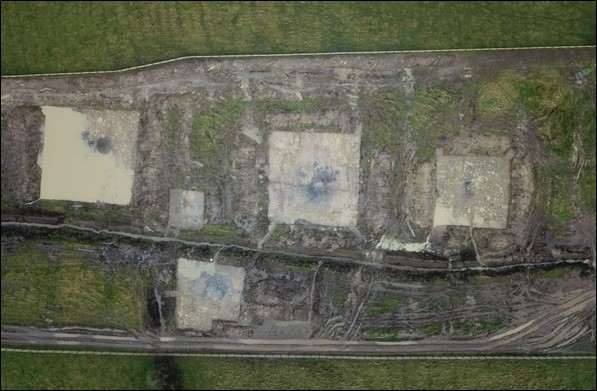
Site type: Burnt spread, Pit and Structure
Period/Dating: Bronze Age (2200 BC-801 BC)
ITM: E 587906m, N 786167m
Latitude, Longitude (decimal degrees): 53.824872, -8.183691
Killeen East 3 was excavated in advance of construction of the N5 Ballaghaderreen to Scramoge Road Project in County Roscommon by Archaeological Management Solutions (AMS) for Roscommon County Council and Transport Infrastructure Ireland. The site was identified during Stage (i)a Test Excavations, carried out by AMS under Ministerial Direction (Direction No. A077, Registration No. E5070; Hardy 2021). Killeen East 3 consisted of eight burnt spreads, with associated troughs, pits, a gully and stake-holes, excavated in five cuttings: Areas A–E.
The on-site Stage (iii) Excavation Services at Killeen East 3 were undertaken by AMS between 27 May and 3 July 2020.
Excavations at Killeen East 3 revealed eight sub-oval or irregular-shaped burnt spreads ranging in size from 2.04m x 0.76m x 0.07m to 12m x 11.8m x 0.21m. Beneath these spreads there were five sub-circular and sub-rectangular troughs ranging in size from 2.24m long, 1.4m wide and 0.34m deep to 1.42m long, 1.15m wide and 0.26m deep. Two of the troughs were connected by a gully 0.73m long, 0.33–0.66m wide and 0.12m deep which may have been used for water management.
No evidence of organic lining was recorded in the troughs at Killeen East 3; however, six stake-holes cut in the base of the largest trough may indicate the presence of a former trough lining. A sample of alder charcoal from the fill of one of the stake-holes returned a Late Bronze Age date: 1051–909 cal. BC (UBA-48807, 2830±24BP). To the east of this trough a cluster of stake-holes covering an area measuring 1.4m by 0.65m was identified. These appear to have formed the outline of a structure of unknown function.
Fifteen pits were also found under the burnt spreads. Some may have functioned as troughs, but their shapes were somewhat irregular. A sample of ash charcoal from the basal fill of one trough returned a Chalcolithic to Early Bronze Age date: 2288–2043 cal. BC (UBA-48804, 3764±30BP). A sample of hazel charcoal from the lower fill of another trough returned a Middle Bronze Age date: 1529–1432 cal. BC (UBA-48803, 3218±24BP). Two troughs appeared to have been clay lined and were cut at the base by a number of stake-holes, which may indicate that these also contained an organic lining. Several of the pits were relatively small for troughs, ranging in size from 0.36m long, 0.34m wide and 0.28m deep to 2.6m long, 1.57m wide and 0.19m deep. A sample of hazel charcoal from the fill of another small pit returned a Chalcolithic to Early Bronze Age date: 2337–2139 cal. BC (UBA-48806, 3794±26BP).
Two artefacts were found during the investigations: a flint flake and a chert flake, both bearing evidence of use as tools. Charred wood macro-remains from the troughs, pits and stake-holes consisted of hazel, ash and oak, as well as alder, blackthorn/cherry, elm, and pomaceous fruitwood. A limited animal bone assemblage from the site largely comprised minute crumbs of calcined bone, some of sheep/goat or pig but mostly indeterminate.
Reference
Hardy, C. 2021. N5 Ballaghaderreen to Scramoge Road Project Stage (i)a, (i)b, (i)c Test Excavation, Stage (i)m Testing in Felled Forestry and Stage (i)f Townland Boundary Survey. Ministerial Direction No. A077, Registration No. E5070. Unpublished AMS report for Roscommon County Council and Transport Infrastructure Ireland.