2020:736 - LUGBOY (2), Roscommon
County: Roscommon
Site name: LUGBOY (2)
Sites and Monuments Record No.: N/A
Licence number: E5192
Author: Brian O'Hara and Brigid Melloy, AMS
Author/Organisation Address: Fahy's Road, Kilrush, Clare
Site type: House - vernacular house and Structure
Period/Dating: Post Medieval (AD 1600-AD 1750)
ITM: E 590102m, N 786307m
Latitude, Longitude (decimal degrees): 53.826177, -8.150342
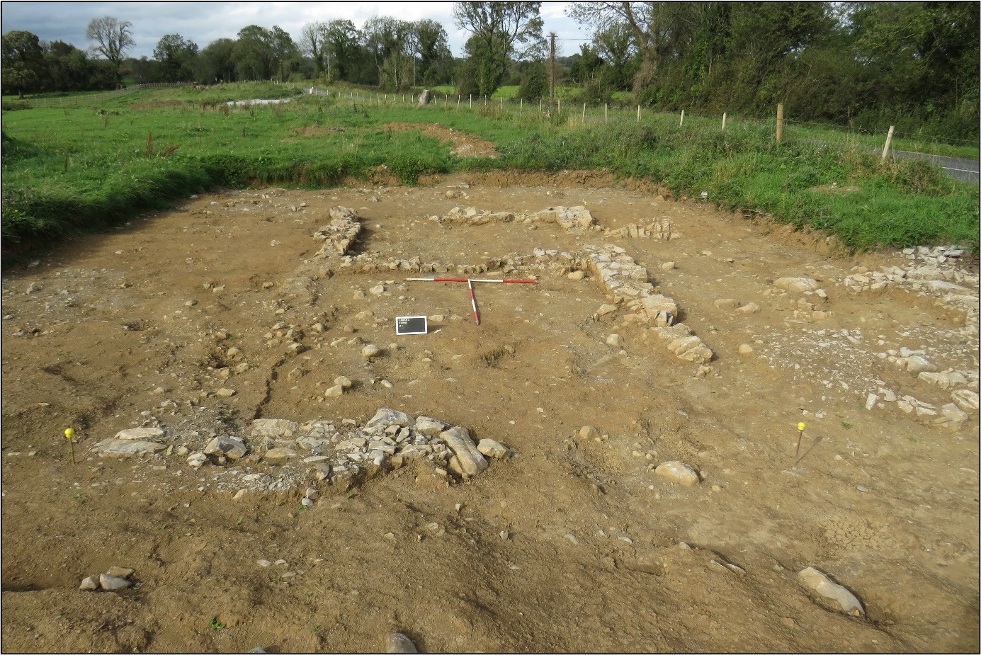
Lugboy 2 was excavated in advance of construction of the N5 Ballaghaderreen to Scramoge Road Project in County Roscommon by Archaeological Management Solutions (AMS) for Roscommon County Council and Transport Infrastructure Ireland. The site consisted of a nineteenth-century vernacular house. The structure is indicated on the first-edition six-inch Ordnance Survey map (1838) and was recorded in the Environmental Impact Assessment Report as part of CHC47, the site of two buildings (Roughan & O’Donovan-AECOM 2017, 314). It was subsequently identified during Stage (i)a Standard Test Excavations carried out by AMS under Ministerial Direction No. A077 (Registration No. E5070; Hardy 2021).
The vernacular structure was a two-roomed direct-entry dwelling orientated north-northwest/south-southeast, 10.7m long and 5.35m wide. Only segments of the external wall foundations survived. No evidence for doors, fireplaces or other such features survived. The remains of a probable boundary wall ran east-northeast to west-southwest, 2m south of the structure, and a stone-kerbed, metalled trackway provided access to the plot from the main road, crossing a box drain, 2–5m east of the structure.
Twenty-five sherds of post-medieval pottery, six clay pipe fragments, an iron spoon, two iron spoon handles, an iron nail shaft, a piece of an iron turf spade, a window-glass sherd, two copper-alloy buttons, a possible stone gaming piece, a roof slate fragment, and a glass bottle sherd were found in the overlying topsoil. These were likely associated with the structure at Lugboy 2. Historical and archaeological evidence both suggest that the structure was dismantled in the post-Famine period as part of the episode of land clearances and reorganisations that took place in that era.
This report was submitted on behalf of its authors.
References
Hardy, C. 2021. N5 Ballaghaderreen to Scramoge Road Project Stage (i)a, (i)b, (i)c Test Excavation, Stage (i)m Testing in Felled Forestry & Stage (i)f Townland Boundary Survey. Ministerial Direction No. A077, Registration No. E5070. Unpublished AMS report for RCC and TII.
Roughan & O’Donovan-AECOM. 2017. N5 Ballaghaderreen to Scramoge Road Project Environmental Impact Assessment Report. TII and Roscommon National Road Design Office. Available at: http://www.roscommoncoco.ie/en/Services/Roads/Publications-and-Information/N5-Ballaghaderreen-to-Scramoge-Road-Project/Environmental-Impact-Assessment-Report/Volume-2B-EIAR-Chapter-11-19/00-EIAR.pdf [Accessed: 29 January 2021].