2020:710 - PEAK (3), Roscommon
County: Roscommon
Site name: PEAK (3)
Sites and Monuments Record No.: N/A
Licence number: E005227
Author: Siobhan McNamara
Author/Organisation Address: —
Site type: Structure and Palaeochannel
Period/Dating: Bronze Age (2200 BC-801 BC)
ITM: E 576950m, N 787902m
Latitude, Longitude (decimal degrees): 53.840093, -8.350225
Peak 3 was excavated in advance of construction of the N5 Ballaghaderreen to Scramoge Road Project in County Roscommon by Archaeological Management Solutions (AMS) for Roscommon County Council (RCC) and Transport Infrastructure Ireland (TII). The site was identified during Stage (i)a Standard Test Excavations carried out by AMS under Ministerial Direction (Direction No. A077, Registration No. E5070; Hardy 2021).
The on-site Stage (iii) Excavation Services at Peak 3 were undertaken by AMS between 4 August and 8 December 2020 in an investigation area totalling 238.5m², with an additional fifteen test trenches following the archaeological remains to the east and west of the main excavation area.
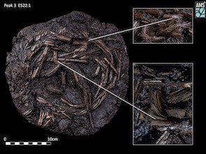
Peak 3 comprised a c.170m roughly east–west aligned drystone wall (C.3/C.6), built on the northern bank of a 3.3–7.4m wide east–west orientated palaeochannel. The wall was 1–2m wide and had an average height of 0.3m–0.63m within the excavated area. A sample of alder and two animal bones recovered from contexts under the wall returned Early and Late Bronze Age dates of 1880–1644 cal. BC (UBA-44477; 3449±27BP), 1206–1013 cal. BC (UBA-45102; 2910±27BP) and 899–805 cal. BC (UBA-44476; 2690±26BP), providing terminus post quem dates for the construction of the wall. A hazel withy rope (E5227:1), radiocarbon dated to the Early Iron Age, 749–411 cal. BC (UBA-45304; 2444±23BP) and the remnants of a possible hazel or willow brushwood trackway were also identified in the large palaeochannel to the south of the wall.

The withy rope was coiled in a subcircular shape, 0.46m east–west by 0.43m north–south, while the brushwood track, 2m x 1.2m, was constructed of small sticks and reed bundles. Several possible metalled surfaces and the surviving arrangement of the stones with and around the stone wall suggested a designed opening or gap that approximated with the possible trackway and stepping-stones to the south. The entire was sealed by peat to an average depth of 1.85m.
Two artefacts were recovered from the site: the hazel withy rope and a stone weight. Fifty-six samples were recovered on site comprising seventeen bulk soil samples, 24 animal bone samples, fourteen wood samples and a seed sample. Charred wood macroremains were recovered from the flotation of the bulk soil samples, sixteen of which produced suitable wood remains for radiocarbon dating which will hopefully help to further refine the chronology for Peak 3.
The archaeological remains at Peak 3 are currently interpreted as prehistoric in date. The drystone wall may have served as a boundary or territorial marker that also reflected the natural topography and drainage. Post-excavation analysis has commenced, and it is anticipated that specialist reports, including radiocarbon dating, will further the interpretation of the site.
This preliminary report summary was submitted on behalf of the author.

Withy Rope
References
Hardy, C. 2021. N5 Ballaghaderreen to Scramoge Road Project Stage (i)a, (i)b, (i)c Test Excavation, Stage (i)m Testing in Felled Forestry and Stage (i)f Townland Boundary Survey. Ministerial Direction No. A077, Registration No. E5070. Unpublished AMS report for TII and RCC.
