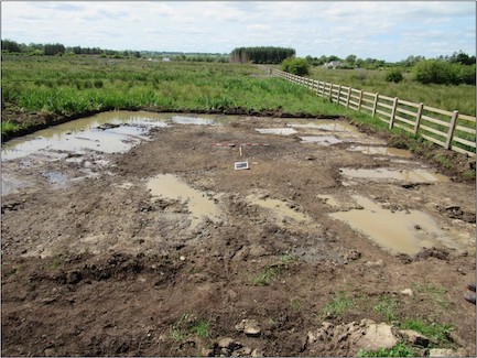
County: Roscommon Site name: Peak 5
Sites and Monuments Record No.: N/A Licence number: E005183
Author: Siobhan McNamara and Kevin Kearney
Site type: Burnt spread
Period/Dating: Prehistoric (12700 BC-AD 400)
ITM: E 577457m, N 787888m
Latitude, Longitude (decimal degrees): 53.839989, -8.342521
Peak 5 was excavated in advance of construction of the N5 Ballaghaderreen to Scramoge Road Project in County Roscommon by Archaeological Management Solutions (AMS) for Roscommon County Council (RCC) and Transport Infrastructure Ireland (TII). The site consisted of a burnt spread located in boggy terrain. It was identified during Stage (i)c Test Excavations in Wetland/Scrub, carried out by AMS under Ministerial Direction (Direction No. A077, Registration No. E5070; Hardy 2021).
The burnt spread consisted of a sub-oval layer of loose, light brown heat-shattered sandstone (70%) mixed with silty clay including small pebbles and gravel. The spread measured 6m long, 4.5m wide and averaged 0.06m deep (max. 0.14m). This feature was heavily truncated and criss-crossed by several phases of agricultural furrows/drains. Charred wood remains from the burnt spread consisted of alder, oak and birch, with a sample of birch charcoal dated to the Late Neolithic/Chalcolithic 2623–2470 cal. BC (UBA47433; 4030±28BP). No associated troughs or pits were recorded at Peak 5.
No artefacts were found during the investigations.
This report summary was submitted on behalf of the authors.
References
Hardy, C. 2021. N5 Ballaghaderreen to Scramoge Road Project Stage (i)a, (i)b, (i)c Test Excavation, Stage (i)m Testing in Felled Forestry and Stage (i)f Townland Boundary Survey. Ministerial Direction No. A077, Registration No. E5070. Unpublished AMS report for TII and RCC.
