2020:661 - STACKALLEN: N51 Dunmoe Phase 2 Scheme, Meath
County: Meath
Site name: STACKALLEN: N51 Dunmoe Phase 2 Scheme
Sites and Monuments Record No.: N/A
Licence number: 20E0223
Author: Red Tobin & Tim Coughlan, c/o IAC Archaeology Ltd.
Author/Organisation Address: Unit G1 Network Enterprise Park, Kilcoole, Co. Wicklow
Site type: Structure and Well
Period/Dating: Undetermined
ITM: E 691879m, N 772416m
Latitude, Longitude (decimal degrees): 53.693364, -6.608799
A programme of archaeological excavation took place between the 30 November and 4 December 2020 at Tober Patrick, Stackallen, Co. Meath, at the site of the proposed N51 Dunmoe Phase II Road realignment. The work was undertaken on behalf of Meath County Council and the Transport Infrastructure Ireland.
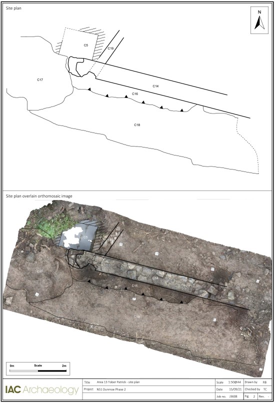
The area was subject to trowel cleaning and some targeted ground reduction to clarify the structural phasing of a wall, referred to in previous reports as the “precinct wall” (C14), and of a rectangular well structure (C5). It was also hoped that some evidence of an earlier well structure might be identified during this work.
Excavations revealed that the ‘precinct wall’ was built in two phases: Phase 1 included the construction of a structure made of random rubble and raised by about four clearly defined courses to form the foundation on which the ‘precinct wall’ was erected; Phase 2 included the erection of the actual ‘precinct wall’, rising from this foundation, but stepped back from the face of its foundation. While the main wall was still constructed of random rubble set in courses, more effort had gone into the selection of the stones used and, in some cases, there was evidence of some surface dressing (mainly to smooth the surface as the finish was not to be seen as ‘rusticated’).
The rectangular well structure was erected within a pre-existing gully/depression which may have corresponded to the location of an earlier well. The gully was deliberately back-filled around the well structure and the area to the west also back-filled to allow the construction of a road/track. The ‘precinct wall’ was erected to enclose the area along the line of the stream and to incorporate the rectangular well structure. While there is clear structural evidence of the well, the wall foundation and the ‘precinct wall’ being built at separate times, it is highly likely that the work all took place within a relatively short time span if not concurrently.
The stonework displayed in the main ‘precinct wall’ and that used to line the rectangular well structure is largely similar and may have been the work of the same masons. It remains highly likely that this work was carried out in tandem with the construction of the bridge and the alterations to the course of the stream carried out to accommodate the bridge.
Moreover, the trowel cleaning defined the metalled surface (C18) of a farm track/road that ran along the south-west side (exterior) of the ‘precinct wall’. The trowel cleaning also provided a clear understanding of a culvert/drain identified in the ‘precinct wall’. This opening allowed water to drain freely from the south-west to empty into the stream to the north via a “roadside gutter” (C16). The roadside gutter was a shallow cut alongside the southern wall face which was likely originally stone lined but little in-situ lining remained and the cut was filled with dark silty clay (C15).

