2020:653 - DUNSHAUGHLIN: Main Street, Meath
County: Meath
Site name: DUNSHAUGHLIN: Main Street
Sites and Monuments Record No.: N/A
Licence number: 20E0041
Author: Marc Piera, c/o IAC Archaeology Ltd.
Author/Organisation Address: Unit G1 Network Enterprise Park, Kilcoole, Co. Wicklow
Site type: Enclosure and Historic town
Period/Dating: Multi-period
ITM: E 696960m, N 752392m
Latitude, Longitude (decimal degrees): 53.512558, -6.538117
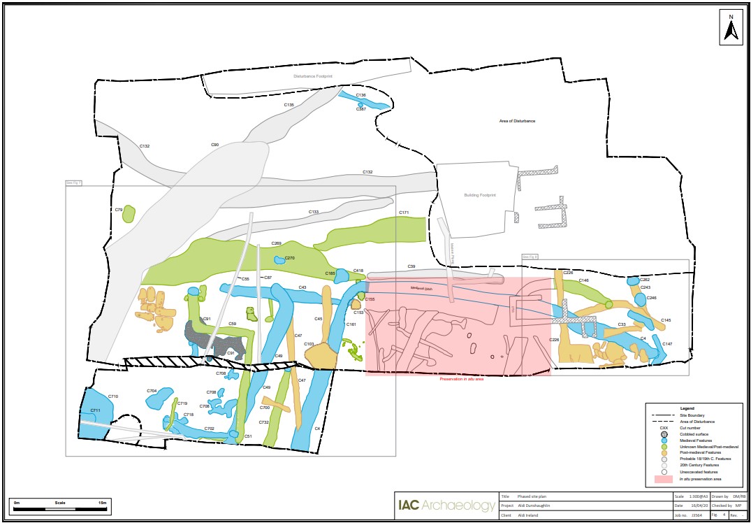
Archaeological excavations were undertaken at Main Street, Dunshaughlin, Co. Meath, in the area where a medieval enclosure ditch (C4/C161) was identified in 2018 during archaeological test trenching.
Excavations were carried out in two phases with the main bulk of the work being carried out between January and March 2020, following the archaeological monitoring of topsoil stripping. The second and final phase was carried out in late June and early July 2020 in the southern part of the development site.
Excavations revealed that the enclosure ditch extended from the south-east extent of the development site, east-west before turning southwards and continuing beyond the southern limit of the development area. A medieval recut was observed inside the enclosure ditch showing cleaning and continued use of the ditch and a terminal at the south-eastern extent may suggest an entrance. The excavation recovered substantial sherds of medieval pottery, animal bones and personal artefacts like bracelet fragments and pins from the fills suggesting possible proximity of nearby habitation. Occasional slag material may indicate a metal-production activity near the area but not specifically on site. Several other medieval ditches, metalled surfaces, linear features, pits and post-holes were also excavated suggesting substantial medieval activity across the site not confined solely to the enclosure.
The excavations also revealed the remains of a significant number of later archaeological features from the medieval up to the recent times. Some features are intercutting earlier ones and the remains of modern buildings were placed above archaeological features, showing a high archaeological density in specific areas of the site.
Some features remain undated currently owing to a lack of dateable finds. This well be addressed during the post-excavation analysis and final reporting phase of the work.
A large hollow (C269) in the central portion of the site contained several medieval/post-medieval ditches, linear features and pits. The central part of the hollow area was heavily disturbed and truncated by the two modern drainage ditches. Further analysis of the finds and samples from this area is required to determine the nature of these features.
The post-medieval phase presents a substantial number and diverse type of features, showing possibly different uses and activities across the site. At the eastern and western limits of the development site two discrete areas contained clusters of shallow pits with associated post- and stake-holes. The cluster in the west, where stake-holes were located around the sides of the pits, may suggest elevated constructions supported by posts. The finds retrieved from this area, pieces of metal, metal slag and sherds of pottery, may represent some sort of industrial activity. The large well shows some management of water.
The 18/19th-century phase consisted of the structural remains of some stone buildings to the east and large ditches to the west that may be part of an old farm. Material retrieved from these areas suggest that they may have been in use into the 20th century.
The last phase of activity on site consisted of a large ditch (C90) and a deposit of rubber (C3) which possibly relate to the demolition and levelling of the farm buildings.
The final interpretation of the site will be determined by the analysis and dating of the samples taken from the excavated features during the post-excavation stage. The results will hopefully confirm function and date of the different features and give a better understanding of the phasing of the features excavated.