2020:624 - NAVAN 2030 SERVICES, ROAD and FOOTPATH WORKS OF 2020 BRIDGE STREET FROM CIRCULAR ROAD TO LUDLOW STREET, Meath
County: Meath
Site name: NAVAN 2030 SERVICES, ROAD and FOOTPATH WORKS OF 2020 BRIDGE STREET FROM CIRCULAR ROAD TO LUDLOW STREET
Sites and Monuments Record No.: ME025-044
Licence number: 19E0519
Author: Niall Roycroft
Author/Organisation Address: c/o Meath County Council
Site type: Historic town
Period/Dating: Multi-period
ITM: E 687646m, N 767735m
Latitude, Longitude (decimal degrees): 53.652037, -6.674195
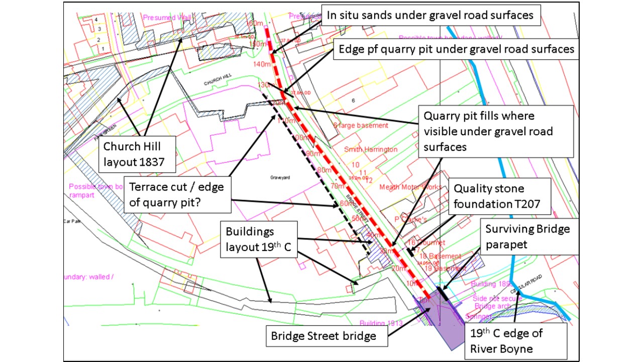
2020 Services works in Bridge Street from Circular Road to Ludlow Street, Navan (ITM: 687143, 767580 to 687646, 767735, Navan Townparks) consisted of a 150m long trench 1.5m to 2m wide by 1.5m to 2.5m deep. Following this, the road and the footpaths were relaid. The service trench is referenced as Chainage (Ch) 000 (34m OD) to Ch160 (37.7m OD) for the purposes of this report and it ran along the ‘Dublin Road’ outside the presumed walled area of Navan Town. Another series of trenches were dug across the Bridge Street-Circular Road junction with a 25m long trench running west along Circular Road. The works were archaeological monitored for Meath County Council.
PHASE 1: NATURAL SANDS, SILTS, GRAVELS AND OCCASIONAL COBBLES
Natural sands are seen in Academy Street a short distance from the Circular Road junction and then reappear again at Church Hill-Bridge Street Junction and were visible further north to the Oriel shop.
The general level for natural sands is around 0.5-0.6m below Present Ground Level (PGL). PGL in Academy Street is 33.9m OD and at Church Hill-Bridge Street PGL is 37.7m OD – 38m OD and at the Oriel Shop PGL is at 37.7m OD.
PHASE 2: QUARRY PITTING PRIOR TO c.1756 Thomas Williams’ Map
Significant quarry pitting and terracing into the western hillside on which The Infirmary (built 1750-1755) and St Mary’s Church of Ireland (shown on 1756 map and rebuilt in early 19th century) are built. Bridge Street is certainly terraced into this rising ground and this area, which is presumed to be ‘outside’ the urban area of Navan would be typically prone to significant sand quarrying (as seen in Abbey Road, Canon Row and Railway Street). The quarrying pre-dates the gravel road surfaces of Phase 3 and the 1756 Williams’ Map shows buildings down the east side of Bridge Street as far south as the pedestrian steps to The Infirmary.
Beyond this, Bridge Street is shown as running through fields. This is not exactly corroborated by the Williams’ Aerial sketch which seems to show housing as far south as the present Church Hill junction area (a mid-19th-century creation).
With The Infirmary being built and The Bridge of Bridge Street, as well as New Bridge over the River Boyne, there is clearly much regeneration in Navan in the first half of the 18th century. This activity is typical for towns in Meath at this time and part of such a regeneration would typically be quarry pitting for sands for mortars and other uses. Therefore, the presumption, failing dating evidence, is that the Phase 3 gravel roads are 18th century and these post-date the quarry pitting and the quarry pitting is at least partly connected with the landscaping of the Bridge Street area with terracing to the west and perhaps embanking on the west side. This work could potentially have removed any earlier medieval roads. There is also the possibility that the quarry pitting is medieval, connected with the first building of Navan in the 12th-13th century and the gravel roads recorded in Phase 3 date from the 13th century to the 18th or even 19th century. The 0.2-0.25m max. thickness of the gravel surfaces seem a bit thin for such a lengthy use of a major thoroughfare (Dublin Road), but it is still possible.
PHASE 3: ROADS, 18th Century Bridge and Foundations to 17 Bridge Street
It was not possible to clearly separate the various gravel surfaces seen outside the Newgrange Hotel as far as The Oriel Shop. Certainly some are later than the Phase 2 Quarrying, others are seen to be lying directly on natural sands and others seem to be the road passing over the 18th-century bridge at the Bridge Street – Circular Road Junction. The date is probably 18th century for this phase, but there is the possibility that the roads are medieval in places.
The Bridge Street bridge is c.36m long x c.14m wide and the garden wall boundary to 1 Bridge Street appears to be the remaining bridge parapet complete with capstones. The bridge had an arch around 7m wide and a separate arch for the culvert for the Leighsbrook Stream on the Academy Street side. Few people realise today that Bridge Street refers to the now-buried Circular Road Bridge and not the bridge viaduct over Academy Street.
The dumps in Circular Road are also included in this phase and these are certainly 18th century or so. The thinly-laid gravel surface seen here reflects the back-street nature of the circular road at this time.
The cut-stone masonry that is now the foundation for 17 Bridge Street is in the location where a potential gatehouse or toll house for Navan might have been created, based on lines drawn from the 1650s Down Survey mapping showing the ‘boundary’ to Navan Urban Area (not necessarily the settlement zone).
PHASE 4 MODERN FEATURES
Modern items and surfaces of Navan as seen from the 2020 works. As far as is known the Beckmeter petrol pumps were not retained.