2020:623 - DONORE: Stalleen Park Housing Project, Meath
County: Meath
Site name: DONORE: Stalleen Park Housing Project
Sites and Monuments Record No.: N/A
Licence number: 19E0445
Author: Niall Roycroft
Author/Organisation Address: c/o Meath County Council
Site type: Testing
Period/Dating: —
ITM: E 704319m, N 772376m
Latitude, Longitude (decimal degrees): 53.690669, -6.420524
Meath County Council proposed to develop a site, to be named Stalleen Park, which is c.1.12 ha—of which c.9,000 is greenfield. The site is located on the western side of Donore village, roughly 400m south-west of Enclosure ME020-074 at its closest point. The site lies within the Buffer Zone of the UNESCO Brú na Bóinne World Heritage Site on the north-facing hillside of a topographic saddle at c. 62–67m OD between Donore Hill (to the north, around 100m OD) and Redmountain ridge (to the south-west, up to 120m OD). The proposed development site is square in shape adjacent to three sides already developed as housing estates built 2004-2010.
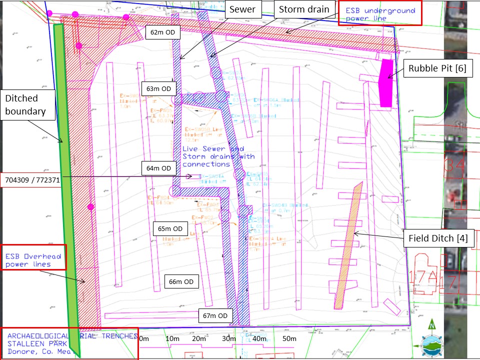
The walkover showed that the site has good views to the Hill of Slane (8.5km), Dowth Great Mound (2.47km), Dowth Church (2.3km) and Netterville House (2.2km). There are also views to the Collon Wind Turbines, Co Louth (>12.5km). The site was agricultural land before 2000 but by 2005 was a set-aside plot within and adjacent to a series of small housing estates then under construction. The site was cut through with new services at that time and stripped of topsoil and subsequently used for storage of large mounds of waste soils and building rubbish. These large mounds were landscaped roughly flat across the site before 2010 and this resulted in a thick layer of modern waste, on average 0.78m thick, across the whole site (although actually ranging from almost nothing to over 2m deep). In addition, a deep trench had been dug in the north-east corner to bury demolition rubble. The rubble pit and a penny dated 1980 demonstrated that material was being imported to the site from elsewhere.
Given the amount of modern rubbish in the ‘imported topsoil’ there was no potential for a metal detecting survey to look for any artefacts that might have come from the 1690 nearby Battle of the Boyne site.
The site sequence revealed weathered post-glacial drift of very dark grey shales and silty clays, overlain by two layers of orange brown colluvial hillwash that were coming down the hillside from the south to the north. Cutting the upper hillwash layer was a presumed post-medieval field boundary ditch (1.8m wide x 0.78m deep) that was traced in a straight line for over 35m with a very clean fill of more hillwash.
The site revealed extensive removal of the original topsoil and possibly much of the underlying colluvial hillwash in many areas as well. No archaeological remains were discovered. The site area of 9,000 sq m was tested with 670 linear metres of trenches totalling 1,206 sq m which is 13.4% of the area. At this percentage it is considered the site has been adequately assessed and no further archaeological fieldwork is required.

