2020:444 - BOGGANSTOWN, Meath
County: Meath
Site name: BOGGANSTOWN
Sites and Monuments Record No.: N/A
Licence number: 20E0668
Author: Angela Wallace, Atlantic Archaeology
Author/Organisation Address: Pier Rd., Enniscrone, Co. Sligo
Site type: Enclosure
Period/Dating: Late Medieval (AD 1100-AD 1599)
ITM: E 698131m, N 739639m
Latitude, Longitude (decimal degrees): 53.397771, -6.524445
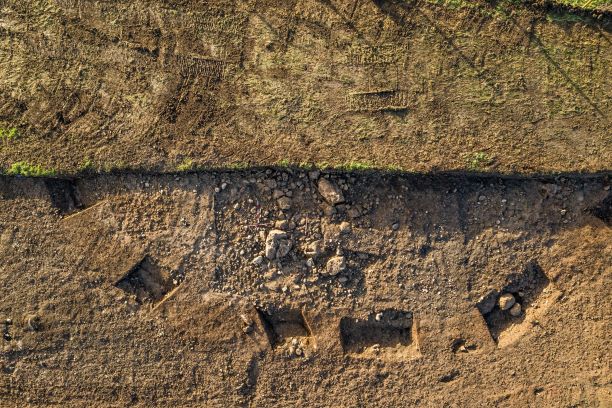
Partial excavation was carried out on a newly discovered enclosure exposed during archaeological testing and monitoring of topsoil stripping in the townland of Bogganstown, Co. Meath. Partial excavation was carried out in advance of works for laying underground cables to facilitate a 2.3km grid route mainly through agricultural land between Kellystown, Co. Kildare and Bogganstown, Co. Meath. The site is located on what appears to be a natural rounded hummock/drumlin with good views over the generally flattish landscape. Like many archaeological sites, the location chosen incorporated natural topography/underlying geology to enhance the setting of the site.
The site was located approximately 25m to the north of a newly identified and excavated small burnt spread or fulacht fiadh (AS1) dated to 2574-2467 Cal BC, which was uncovered during the testing programme (Licence No. 20E0240).
Excavation revealed a well-defined curving ditch measuring c. 28m in internal diameter and c.30m in external diameter. Some stone-lined post-holes were identified at the base of the ditch on north-east side, suggesting some sort of fence or palisade at this location.
Partial excavation within the enclosed area revealed a complex enigmatic site. Within this area a stony layer was identified with an east-west linear arrangement (C17) of two parallel rows of angular rocks set firmly into a subsoil layer, measuring c.4.25m east-west (probably continues further west) and 0.8-1.25m apart, with at least two small circular formations and one possible oval formation either side of a linear path/passage. Less than one third of the enclosure site was exposed, the stone formations may be incorporated into a much larger and more complex setting extending westwards within the enclosed area.
Apart from three surface finds of flint debitage there were no other artefacts recovered within the enclosed area. Three flint flakes and one scraper were recovered within enclosing ditch fills. No evidence for any burials or cremation deposits was found. There was no evidence for any type of occupation deposits, debris or hearths; very minute quantities of environmental material were recovered from processing of soil samples taken around the excavated area.
Given gravelley fills and surrounding landscape and evidence for large boulders in the vicinity, it seems likely there may have been a gravelley cairn or mound over the enclosed area (the landowner recalls his father removing large rocks from the area). The presence of a small quantity of lithics, the nature of the site and its proximity to a burnt spread dated to the Early Bronze Age and ring ditches (usually of Bronze Age/Iron Age date) points to a prehistoric origin, likely of a ritual/ceremonial function. It is not unusual to have an absence of burial and artefactual evidence within barrows and ring ditches. Some theories indicate these sites were more important as ancestral territorial markers in the landscape or as waymarks along significant route ways.
No dateable material was found in samples from basal fills of the ditch. A single oat grain from a re-cut of the enclosing ditch (C04) was recovered from wet sieving, which returned a date of 422+/-39 BP Cal 1421–1625AD (95.4% probability) and a single cereal grain from C19, a deposit within the enclosure area returned a date of 97+/-26 BP or Cal 1688-1925AD (95.4% probability). These later dates add further complications to the interpretation of the site.
To the south-east, in the townland of Knockudder, there is an Anglo-Norman motte (ME053-003), which were typically constructed in the 12th and 13th centuries AD. Ravensdale House, an 18th-century Dower House is situated to the south and the 17th-century Carton House is to the south-west. The presence of a later medieval moated site nearby and the surrounding demesne houses, associated land improvements and landscape design elements may have led to a later re-use or adaptation of an earlier prehistoric site.

