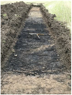
2020:408 - BALLYMACARNEY, Meath
County: Meath
Site name: BALLYMACARNEY
Sites and Monuments Record No.: N/A
Licence number: 20E0702
Author: John Ó Néill, IAC Ltd.
Author/Organisation Address: For Irish Archaeological Consultancy Ltd
Site type: Burnt mound
Period/Dating: Prehistoric (12700 BC-AD 400)
ITM: E 708680m, N 745750m
Latitude, Longitude (decimal degrees): 53.450602, -6.363785
Archaeological testing was undertaken to study the impact, if any, on the archaeological and historical resource of a solar farm development, which is located at Ballymacarney, County Meath. It follows a geophysical survey (licence 20R0101) carried out by Target Archaeological Geophysics in 2020.
Archaeological testing was carried out over the course of five days in December 2020 using a mechanical excavator fitted with a flat grading bucket. The trenches targeted geophysical anomalies and linear elements of the development to fully investigate the archaeological potential of the site. Testing revealed thirteen areas of archaeological significance, which have been designated as AA1–13. These comprise twelve areas of burnt mound activity (AA1-AA8, AA10-AA13) and one pit (AA9).
One trench (Trench 39) was not opened on safety grounds.
Summary of results:
Testing across Fields 1 to 8 identified a depth of 0.35–0.4m of a heavy clay topsoil that had been used for cultivation in recent years. This overlay a mixed subsoil containing yellow-grey, grey and orange-brown clays with frequent limestone inclusion and bands of relatively stone-free clay. The footprint current layout is largely identical to the mid-nineteenth-century Ordnance Survey maps apart from Fields 7 and 8 which have been created by merging two sets of smaller fields into two larger fields.
Many of the former field boundaries were generally visible during testing as linear ditches cut into subsoil and filled with mid-brown clays, stones and shrub roots. Due to the levels of water percolating in the subsoil, there had been numerous attempts at draining the fields with a variety of drainage features noted including gullies, stone-lined drains, clay pipes and gravel drains, all likely to date to after 1800 and some had been constructed in recent memory.
Thirteen areas of archaeological significance were recorded and are described below.
AA1
Investigation of Trench 1 identified a deposit of fire-cracked stone, mainly sandstone, in a charcoal-rich clay. The burnt stone was mainly small pieces of sandstone (generally less than 50mm in diameter) which appears to have been deliberately selected for use as the local geology tends towards limestone. The use of the sandstone indicates the capture and transfer of heat from fire to water, presumably to boil food (since heated limestone will turn caustic in water and render food inedible). The reduced diameter indicates repeated use. Sites where food (or other products) are prepared in this way are typically known as burnt mounds (or fulachta fiadh) and can date from as early as 3700 BC to the medieval period, although generally tend to date from the Bronze Age. Most of the Archaeological Areas identified at Ballymacarney are burnt mounds similar to AA1.
AA2
Investigation of Trench 6 identified a deposit of fire-cracked stone, mainly sandstone, in a charcoal-rich clay.
AA3
Investigation of Trench 14 identified a deposit of fire-cracked stone, mainly sandstone, in a charcoal-rich clay.
AA4
Investigation of Trench 15 identified a deposit of fire-cracked stone, mainly sandstone, in a charcoal-rich clay.
AA5
Investigation of Trenches 17, 18 and 19 identified a series of deposits of fire-cracked stone, mainly sandstone, in a charcoal-rich clay. These deposits were located over an area covered by the three trenches.
AA6
Investigation of Trench 28 identified a deposit of fire-cracked stone, mainly sandstone, in a charcoal-rich clay.
AA7
Investigation of Trenches 35 and 36 identified deposits of fire-cracked stone, mainly sandstone, in a charcoal-rich clay.
AA8
Investigation of Trenches 37 and 38 identified deposits of fire-cracked stone, mainly sandstone, in a charcoal-rich clay.
AA9
Investigation of Trench 42 identified a deposit of fire-cracked stone, mainly sandstone, in a charcoal-rich clay.
AA10
Investigation of Trench 43 identified a single pit of unknown date (only a small proportion of the pit was investigated). Given the proximity of the pit to AA9 and the intensity of burnt mound activity evidenced across Fields 7 and 8, it is potential evidence for contemporary prehistoric settlement activity.
AA11
Investigation of Trenches 57 and 58 identified deposits of fire-cracked stone, mainly sandstone, in a charcoal-rich clay.
AA12
Investigation of Trench 59 identified a deposit of fire-cracked stone, mainly sandstone, in a charcoal-rich clay.
AA13
Investigation of Trench 62 identified a deposit of fire-cracked stone, mainly sandstone, in a charcoal-rich clay.

