2020:579 - POLLSHARVOGE (1), Mayo
County: Mayo
Site name: POLLSHARVOGE (1)
Sites and Monuments Record No.: N/A
Licence number: 19E0798
Author: Bruce Sutton for Rubicon Heritage Services Ltd.
Author/Organisation Address: Unit 2, Europa Business Park, Midleton, Co. Cork, P25 TV25
Site type: Burnt mound
Period/Dating: Prehistoric (12700 BC-AD 400)
ITM: E 533785m, N 801622m
Latitude, Longitude (decimal degrees): 53.959657, -9.008970
Excavation at Pollsharvoge 1, as part of the N26 Cloongullaun Road Realignment Scheme, Co. Mayo, revealed a large, intact burnt mound with two underlying timber troughs.
The mound was 11m long, 9m wide and 0.9m deep and comprised of eight layers. There had been three periods of activity at the site: during the Neolithic period, 2575–2471 BC, the Middle to Late Bronze age, 1207–806 BC, and the Late Bronze Age to Iron Age, 753–391 BC. Dating evidence and the substantial quantity of mound material accumulated suggests a prolonged use in the Iron Age. The features on site consisted of a small Neolithic burnt spread on the periphery. Middle to Late Bronze Age activity comprised a roundwood-lined trough, with a stone hearth at the eastern end, a dump of charcoal, and associated lower mound layers. Iron age activity consisted of a large plank and roundwood trough with a possible lightweight structure, such as a rack or windbreak, at the eastern end and associated upper mound layers. A stone path led to this trough from off-site to the north-west, likely to facilitate access to the area.
Trough 022 was Middle to Late Bronze Age in date, located along the southern side of the main mound, orientated east-west. It measured 1.3m long, 1m wide and 0.4m deep. The cut was rectangular in shape, with straight, almost vertical sides and was cut into underlying peat 008. The trough had a bushwood and roundwood lining (030) and a stone hearth was located at the eastern end, in a shallower semi-circular cut (042) that measured 0.7m x 0.55m x 0.15m deep.
Timber lining 030 lay directly on the underlying peat and consisted of 52 individual wood elements close to the cut edge. All pieces of wood were waterlogged, and many were soft to tough, with several being badly degraded, and all damaged by sphagnum roots. The lining consisted entirely of brushwood and roundwood and included the base, four sides and corner pegs. In total there were sixty-one worked ends identified; twenty-six chisel points, twenty-four wedge points, four pencil points and 7 ends worked but not specified. Twenty-nine ends were too damaged or degraded to identify if they were worked.
The base consisted of twenty-two brushwood (wood 121, 123-125, 127, 129-133 & 135-146) and five roundwood (wood 120, 122, 126, 128 & 134) elements laid horizontally. These ranged in size from 0.19m to 1.41m in length, with twenty-four out of the twenty-seven measuring over 1m. Several of the elements lay slightly underneath others, but all appeared to have been inserted as a single construction event, rather than multiple levels. Elements continued under the eastern and western side timbers. Nearly all of the pieces were worked at both ends, or too damaged to identify and one element (wood 141) had evidence of branch trimming, where small branches had been torn or ripped off. One small element (wood 121), measuring 0.19m, was unworked and burnt at one end, suggesting it may have been thrown in during construction of the timber lining, or shortly after. Fifty of the wood elements were submitted for taxa identification. Forty-nine were identified as hazel and one was identified as ash.
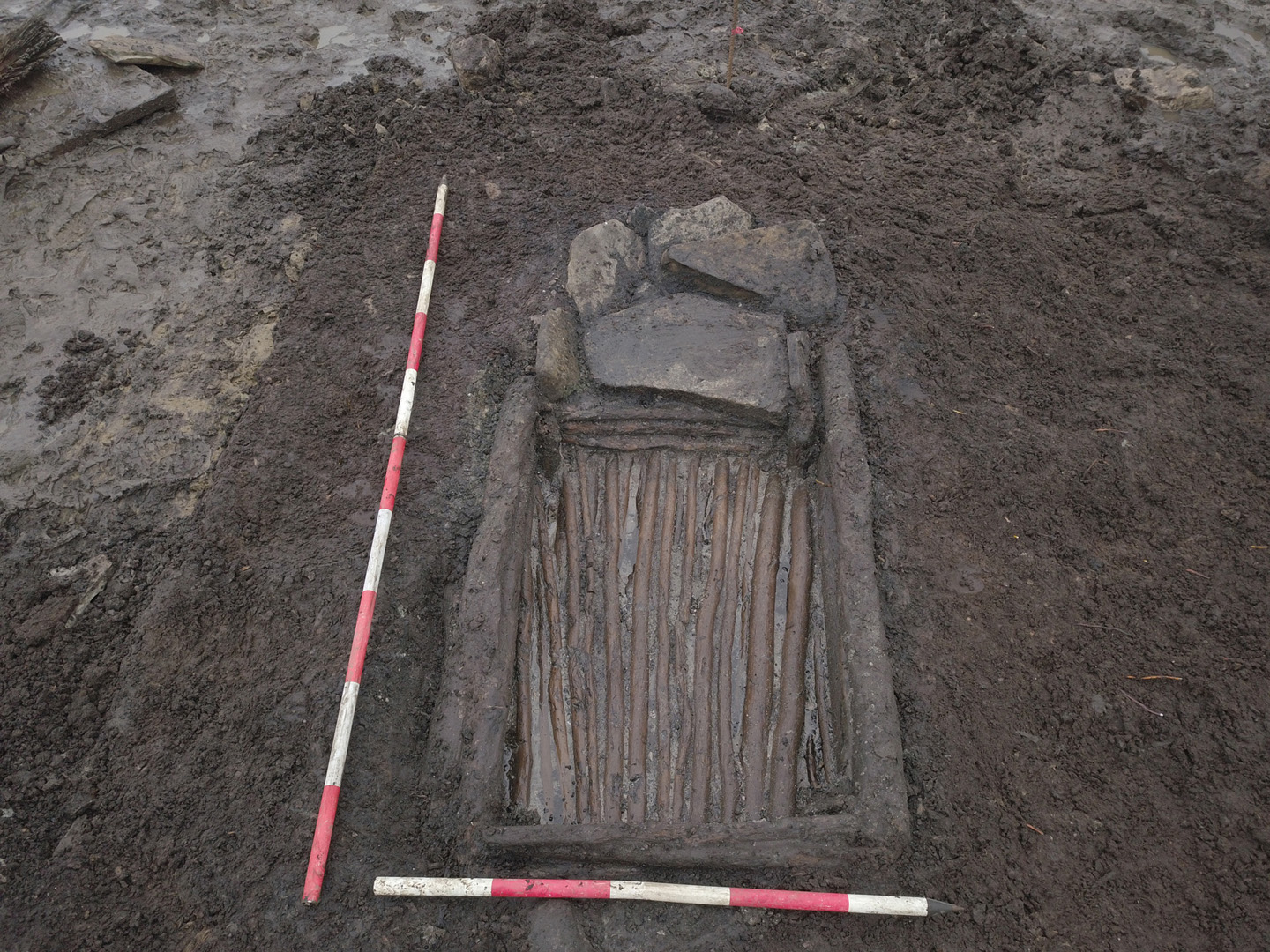
Trough 021 was Iron Age in date. It was orientated east-west and measured 2.5m x 1.65m x 0.4m deep. It was cut directly into underlying peat 008, terminating at the level of underlying subsoil 002 and located at the northern edge of the main mound. The cut was sub-rectangular in plan, with steep sides and a flat base and contained a timber lining with several incorporated stones. The initial fill material 037 was a layer of sand and moss laid down across much of the base but was deepest in the centre. It was likely laid down to filter water as it entered the trough, but also levelled the slightly uneven cut.
Above this initial sand/moss layer (037) was a substantial timber lining (035), which consisted of forty-six individual pieces of wood. All pieces of wood were waterlogged, and many were soft to tough, with several being badly degraded, and all damaged by sphagnum roots. The lining comprised of a plank and roundwood base and sides, with twenty-three pegs. Several stones had also been incorporated into the construction. Species identified in the lining consisted of hazel, alder, ash, oak and pomaceous wood (fruit tree). In total there were forty-seven identified worked ends identified in timber lining 035; ten chisel points, nine wedge points, twenty pencil points and eight ends worked but not specified. Four ends were too damaged or degraded to identify if they were worked. All identified facets were relatively flat.
One-hundred and fourteen wood samples were analysed from Pollsharvoge, dating from the Late Bronze Age and the Iron Age. The majority of the timbers come from two contexts: the lining of Late Bronze Age trough 022 (50 timbers) and the lining of Iron Age trough 021 (44 timbers). Fifteen timbers were examined from two Iron Age stake groups. Five native Irish wood taxa were identified. The most common is hazel, followed by alder and ash. One sample of oak and one of pomaceous fruitwood were also identified. Facets show the use of flat and convex shaped blades, up to 35mm in width from the Late Bronze Age and up to 40mm in width from the Iron Age. The axes used were sharp and capable of cutting cleanly and deeply into the wood, leaving mainly clean and some stepped facet edges. From the Late Bronze Age, smaller diameter wood was cut with one chop, while from the Iron Age, larger diameter wood could be successfully felled with one chop, perhaps indicating that the heavier Iron Age axes were more adept at cutting larger wood.
The pollen and charcoal analysis tied in well with the wood used in trough construction. The assemblages indicate that site was located near to woodland, possibly at the woodland edge with remains of birch (likely silver birch), alder, holly, hawthorn and hazel all present. Despite the drier ground preferred by trees such as hazel, birch and holly, the local ground around the site would have been damp, signalled by the occurrence of sedges (probable marsh cudweed and greater spearwort) in the assemblage. That woodland grew near to the site is also indicated by woodland ground flora such as wood sorrel, bugle, brambles, common chickweed, common hemp‐nettle and creeping buttercup.