2020:688 - KILKENNY: No. 73 Maudlin Street, Gardens, Kilkenny
County: Kilkenny
Site name: KILKENNY: No. 73 Maudlin Street, Gardens
Sites and Monuments Record No.: N/A
Licence number: 20E0593
Author: Grace Fegan & Marion Sutton; Shanarc Archaeology Ltd.
Author/Organisation Address: —
Site type: Historic town
Period/Dating: Multi-period
ITM: E 651055m, N 655970m
Latitude, Longitude (decimal degrees): 52.652519, -7.245444
Archaeological test-excavations were carried out as part of an archaeological impact assessment in association with an application for the proposed development of a two-storey dwelling in the rear garden at 73 Maudlin Street, Kilkenny.
The proposed development is located to the rear of 73 Maudlin Street, a property situated in the Gardens townland, in the Parish of St John, on the eastern bank of the River Nore. The predominant character of Maudlin Street is urban residential, with some housing dating to the early 19th century, and several more recent additions. 73 Maudlin Street fronts onto the south side of the street, approximately 200m south-east of the junction with John Street Upper/Lower, within the zone of archaeological potential of the historic town (RMP KK019-062). The property is situated approximately 115m outside the town wall that surrounded the medieval suburb of St John, but within an enclosure for the medieval leper hospital of St Mary Magdalen. Maudlin or Magdalen Tower House/Castle (RMP KK019-026074) is situated 35m to the east, and marks the site of the gate leading into the hospital enclosure; the development site at 76 Maudlin Street falls within the archaeological zone of notification (Zone ID: R191613) associated with the tower house. The rear of the property borders onto a historic laneway, Lime Tree Lane, which is aligned along an infilled medieval millstream on the Gardens townland boundary with Collegepark. The millstream serviced the Magdalen Mill on the River Nore, which was sited approximately 130m to the south-east.
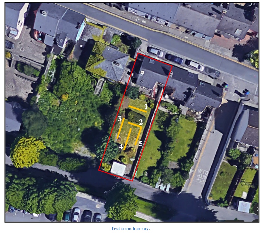
Five test trenches were excavated across the site; trenches had a length of 4–6.5m, width of 1.5m and a depth of 1.2–1.59m. Excavated material consisted primarily of made ground comprising c.0.05m of topsoil overlying c.0.05m of orange-brown garden soil, overlying 0.42–0.9m of modern demolition rubble over c.0.4–0.5m of blackened clay with modern refuse, overlying natural mid-brown sandy silt. A lime mortared stone wall was exposed at a depth of c.1m in Trenches 1 and 3 and likely represents the former west boundary wall of the property; aside from this no archaeological features or finds were discovered during testing.