2020:379 - KILDARE: Rathbride Road, Kildare
County: Kildare
Site name: KILDARE: Rathbride Road
Sites and Monuments Record No.: N/A
Licence number: 17E0125
Author: Antoine Giacometti, Archaeology Plan
Author/Organisation Address: 32 Fitzwilliam Place Dublin 2
Site type: Excavation - miscellaneous
Period/Dating: Multi-period
ITM: E 673230m, N 713940m
Latitude, Longitude (decimal degrees): 53.167831, -6.903220
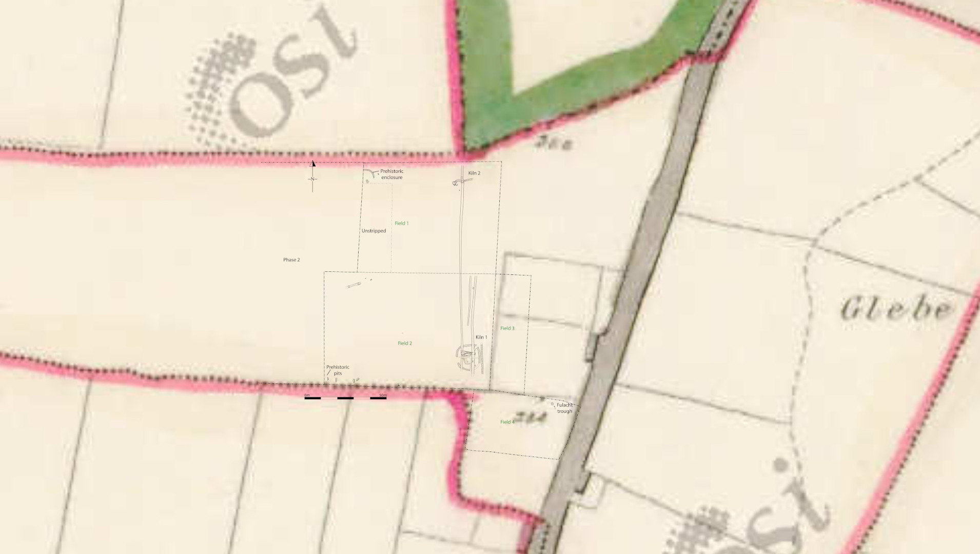
A programme of archaeological excavation took place at the residential development site to the west of the Rathbride road, north of Kildare town, and within the townland of Kildare. The excavation took place on a phased basis from April 2019 to February 2020. Only the eastern half of the site was excavated, and the western half was left for a future phase of groundworks.
The site is located at the edge of the Curragh, an open grassland that was a focal point for prehistoric activity. The earliest evidence for occupation was a cluster of pits that contained sherds of an Early Neolithic carinated bowl. They may represent small offering pits, and are the earliest evidence of human occupation in the wider area to date, dating to c. 3900–3600BC on the basis of the pottery. A small, possibly short-lived, fulacht fiadh site was also found. A penannular enclosure, possibly also of prehistoric date, was identified during the monitoring programme, however this was not excavated and is to be dealt with in a second phase of works on the site.
The most substantial features uncovered were two cereal-drying kilns, both of which are preliminarily dated to the early medieval period. Both were partially stone-lined, one comma-shaped and the other dumbbell-shaped in plan. The latter kiln was located within a circular enclosure that appeared contemporary. A four-posted structure, possibly representing a raised grain store or granary, was also excavated within the kiln enclosure. It was associated with a shallow depression that may have served as a threshing surface. These were not associated with any additional early medieval settlement and may have been attached to the powerful abbey of St Brigit’s at Kildare. The lack of protection around the features may be indicative of the power the abbey held over its hinterland. A later medieval field system truncated the kilns, and represented agricultural changes carried out within the lands of the abbey after the arrival of the Anglo-Normans. Both this field system, and the location of the kilns, relate to an earlier division of the townland system when this land probably formed part of Cloghgarret (refer attached OS1 map).