2020:545 - FARRANNACARRIGA (1), Kerry
County: Kerry
Site name: FARRANNACARRIGA (1)
Sites and Monuments Record No.: N/A
Licence number: E005273
Author: Zbigniew Malek, Archaeological Management Solutions Ltd.
Author/Organisation Address: Fahy’s Road, Kilrush, Co. Clare
Site type: Charcoal-mkaing site, Pit and Burnt spread
Period/Dating: Multi-period
ITM: E 457760m, N 601420m
Latitude, Longitude (decimal degrees): 52.146293, -10.078380
Stage (iii) Excavation was carried out between 11 and 19 November 2020 at the site of Farrannacarriga 1 in advance of construction of the N86 Ballynasare Lower to Annascaul and Doonore North to Ballygarret Road Improvement Scheme, Co. Kerry. The work was carried out under Ministerial Direction Number A070 and Registration Numbers E005273 (Excavation) and R000545 (Metal Detection), on behalf of Kerry County Council. The site was discovered in the eastern area of the Ballynasare Lower to Annascaul section of the scheme in the townland of Farrannacarriga during advance Stage (i) Test Excavations undertaken in 2020 by Archaeological Management Solutions Ltd.
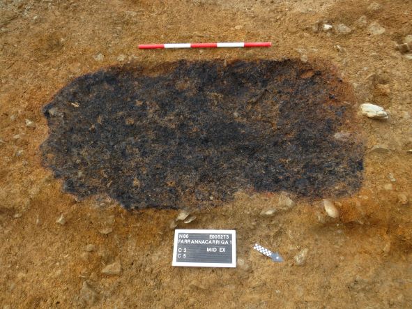
The archaeology of Farrannacarriga 1 comprised two charcoal-production pits, two pits, a gully and a spread. Post-medieval/modern features consisting of a field drainage ditch and two field drains were also recorded. The ditch truncated one of the charcoal-production pits. The first charcoal-production pit was sub-rectangular in plan, measured 2.18m by 1.18m by 0.18m in depth and contained two fills, with in-situ burning of the subsoil at the bottom and around the edges and sides of the cut. The second charcoal-production pit was sub-oval in plan, measured 1.34m by 0.86m by 0.11m in depth and contained two fills, also with in-situ burning of the subsoil at the bottom and around the edges and sides of the cut.
The first pit was figure-of-eight-shaped in plan, measured 0.97m by 0.64m by 0.29m in depth and contained two fills. The second pit was subcircular in plan, measured 0.77m by 0.72m by 0.3m in depth and contained a single fill. The gully was linear in plan, measured 1.4m by 0.36m by 0.14m in depth and contained a single fill. The spread was irregular in plan and measured 3.2m by 1.18m by 0.18m in depth. These features were situated within a large natural hollow, overlain by a non-archaeological deposit.
In the absence of absolute dating, given the nature of the site type, it would not be unreasonable to suggest a medieval date for the archaeology at Farrannacarriga 1.
Post-excavation analysis is ongoing and it is anticipated that specialist reports, including radiocarbon dating and comparative research, will further enhance our understanding of the site.