2020:544 - GURTEEN (1), Kerry
County: Kerry
Site name: GURTEEN (1)
Sites and Monuments Record No.: N/A
Licence number: E005303
Author: Zbigniew Malek, Archaeological Management Solutions Ltd.
Author/Organisation Address: Fahy’s Road, Kilrush, Co. Clare
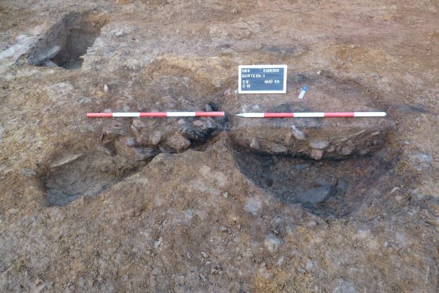
Site type: Burnt mound and Pit
Period/Dating: Bronze Age (2200 BC-801 BC)
ITM: E 457928m, N 601460m
Latitude, Longitude (decimal degrees): 52.146695, -10.075944
Stage (iii) Excavation was carried out between 7 and 16 December 2020 at the site of Gurteen 1 in advance of construction of the N86 Ballynasare Lower to Annascaul and Doonore North to Ballygarret Road Improvement Scheme, Co. Kerry. The work was carried out under Ministerial Direction Number A070 and Registration Numbers E005303 (Excavation) and R000545 (Metal Detection), on behalf of Kerry County Council. The site was discovered in the eastern area of the Ballynasare Lower to Annascaul section of the scheme in the townland of Gurteen during advance Stage (i) Test Excavations undertaken in 2020 by Archaeological Management Solutions Ltd.
Gurteen 1 consisted of a burnt mound deposit and two roasting pits. The burnt mound deposit was irregular in plan and measured 3.05m by 2.02m and was 0.12m in depth. It consisted of a single deposit of heat-affected stones in a charcoal-rich matrix. The two roasting pits were located in close proximity to the burnt mound deposit. The first roasting pit was subcircular in plan and measured 1.2m by 1.12m by 0.3m in depth and contained four fills, of which one was charcoal rich. The middle fill consisted of clayey silt with frequent small angular heat-affected stones. Overlying the upper fill of this pit were two charcoal spreads which measured 0.6m by 0.54m by 0.04m in depth and 0.98m by 0.38m by 0.04m in depth respectively and were associated with in-situ burning. This roasting pit had in-situ burning of the subsoil at the bottom and around the sides of the cut. The second roasting pit was abutting the western side of the first roasting pit. It was irregular in plan, measured 1.9m by 1.3m by 0.23m in depth and contained seven fills, of which four were charcoal rich. The base in the central portion of the pit was stone-lined. Intense in-situ burning of the subsoil was present only at the east-north-eastern side of the cut abutted by the stone lining. The upper fill comprised heat-affected stones in a clayey silt matrix.
An agricultural drainage ditch was located along the northern edge of the site. The ditch had maximum exposed dimensions within the excavation area of 10m in length by 1.32m in width by 0.5m in depth and it contained seven fills. It was oriented east-north-east/west-south-west and its terminus was in the north-eastern corner of the site. The ditch truncated one of the roasting pits. A flint flake was recovered from a soil sample of the secondary fill of the ditch during post-excavation processing. The flint flake could have originated from the truncated roasting pit.
In the absence of absolute dating, given the nature of feature types, it would not be unreasonable to suggest a Bronze Age date for the roasting pits and burnt mound deposit. The date of the agricultural drainage ditch is uncertain.
Post-excavation analysis is ongoing and it is anticipated that specialist reports, including radiocarbon dating and comparative research, will further enhance our understanding of the site.