2020:543 - GORTACURRAUN (5), Kerry
County: Kerry
Site name: GORTACURRAUN (5)
Sites and Monuments Record No.: N/A
Licence number: E005270
Author: Niall O'Hora, Archaeological Management Solutions Ltd.
Author/Organisation Address: Fahy’s Road, Kilrush, Co. Clare
Site type: Charcoal-making site
Period/Dating: Multi-period
ITM: E 456870m, N 601340m
Latitude, Longitude (decimal degrees): 52.145344, -10.091342
Stage (iii) Excavation was carried out between 05 and 24 November 2020 at the site of Gortacurraun 5 in advance of construction of the N86 Ballynasare Lower to Annascaul and Doonore North to Ballygarret Road Improvement Scheme, Co. Kerry. The work was carried out under Ministerial Direction Number A070 and Registration Numbers E005270 (Excavation) and R000545 (Metal Detection), on behalf of Kerry County Council. The site was discovered in the western area of the Ballynasare Lower to Annascaul section of the scheme in the townland of Gortacurraun during advance Stage (i) Test Excavations undertaken in 2020 by Archaeological Management Solutions Ltd.
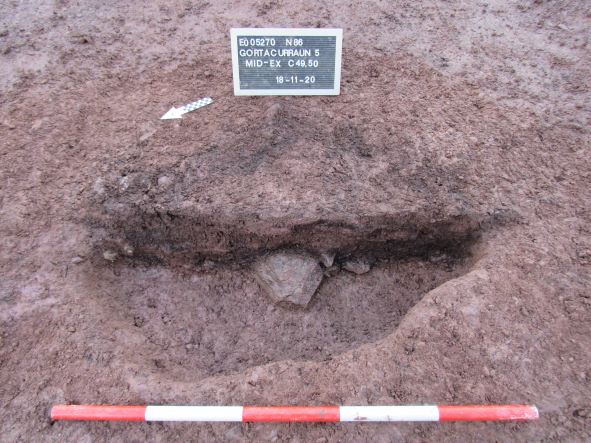
The site of Gortacurraun 5 consisted of two charcoal-production pits, 24 pits, nine stake- and five post-holes.
The first charcoal-production pit was sub-oval in plan, measured 1.98m by 1.28m by 0.12m in depth and contained two fills. The second charcoal-production pit was also sub-oval in plan, measured 1.18m by 0.97m by 0.12m in depth and contained three fills. A shallow pit measuring 1.07m by 0.82m by 0.11m in depth located in the central area of the site contained a charcoal-rich fill. It is possible this may also have been a charcoal-production pit that was heavily disturbed through agricultural activity.
Two of the pits contained heat-shattered stone, representing pyrolithic or hot-stone technology. One of these pits was the latest in a series of three intercutting pits in the western area of the site. This pit was irregular in plan, measured 0.85m by 0.8m by 0.28m in depth and contained two fills. The upper fill, which contained the heat-shattered stones, also contained charcoal and occasional burnt bone. The earliest of the three intercutting pits was sub-oval in plan, measured 1.17m by 0.88m by 0.65m in depth and contained three fills, one of which contained a flint flake. The second pit was irregular in plan, measured 1.09m by 1.07m by 0.49m in depth and contained two fills, one of which contained occasional charcoal chunks, occasional burnt bone fragments and occasional patches of oxidised clay. The second pit containing heat-shattered stone was located in the eastern area of the site and was sub-oval in plan, measured 1.74m by 1.6m by 0.32m in depth and contained two fills, the uppermost containing the heat-shattered stones.
Two closely-spaced pits in the north-western area of the site contained charcoal-rich lower fills with overlying oxidised fills, possibly indicating in-situ burning. The first pit was sub-circular in plan, measured 1.1m by 0.99m by 0.27m in depth and contained two fills. Two worked quartz crystal flakes and ten sherds of prehistoric pottery were recovered from this pit. The second pit was sub-circular in plan, measured 0.44m by 0.34m by 0.17m in depth and contained two fills. Two flint flakes and one quartz crystal flake were recovered from this pit. Located to the south-west of these pits was a large pit that measured 2.7m by 1.24m by 0.25m in depth. It contained a single fill, which produced a worked quartz crystal flake.
Six stake-holes at Gortacurraun 5 contained the possible remains of charred stakes. Four of these stake-holes were clustered together near the south-western edge of the site. There was no clear form to the cluster in plan and the stake-holes were disturbed. As they were situated very close to the western boundary of the site it may be possible that they were originally associated with a structure or feature that lies beyond the excavation area. Two stake-holes were located in the northern area of the site but were not associated with any other features. A single post-hole was located at the very northern edge of the site, while a single post-hole was also located in the south of the site.
The majority of the remaining features at Gortacurraun 5 were shallow pits which produced no material indicative of function with many pits containing sterile fills.
Overall, the archaeological features at Gortacurraun 5 likely demonstrated peripheral activities located away from areas of primary occupation. While the artefactual evidence suggests prehistoric activity, some features may have represented peripheral activity associated with ringfort KE004-106 which was located approximately 300m to the north-west. Therefore, in addition to the evidence for a prehistoric date, some features may date to the medieval period.
Post-excavation analysis is ongoing and it is anticipated that specialist reports, including radiocarbon dating and comparative research, will further enhance our understanding of the site.

