2020:541 - BALLINCLARE (1), Kerry
County: Kerry
Site name: BALLINCLARE (1)
Sites and Monuments Record No.: N/A
Licence number: E005272
Author: Zbigniew Malek, Archaeological Management Solutions Ltd.
Author/Organisation Address: Fahy’s Road, Kilrush, Co. Clare
Site type: Burnt mound and Charcoal-making site
Period/Dating: Undetermined
ITM: E 457985m, N 601465m
Latitude, Longitude (decimal degrees): 52.146755, -10.075114
Stage (iii) Excavation was carried out between 14 November and 4 December 2020 at the site of Ballinclare 1 in advance of construction of the N86 Ballynasare Lower to Annascaul and Doonore North to Ballygarret Road Improvement Scheme, Co. Kerry. The work was carried out under Ministerial Direction Number A070 and Registration Numbers E005272 (Excavation) and R000545 (Metal Detection), on behalf of Kerry County Council. The site was discovered in the eastern area of the Ballynasare Lower to Annascaul section of the scheme in the townland of Ballinclare during advance Stage (i) Test Excavations undertaken in 2020 by Archaeological Management Solutions Ltd.
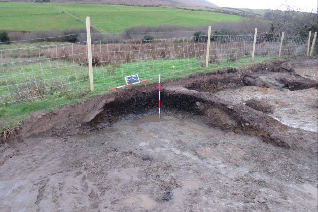
Ballinclare 1 consisted of four burnt mounds, a charcoal-production pit, pits, gullies and agricultural drainage ditch. The site was located in poorly drained, wet and marshy ground adjacent to a small but deeply-incised stream, representing the Ballinclare/Gurteen townland boundary.
The main burnt mound extends beyond the limit of excavation to south, outside the lands made available for the road scheme. It was sub-oval in plan, measured 12.5m by 11.5m by 0.54m in depth and comprised three deposits of charcoal-rich soil with frequent heat-shattered sandstones. A drainage gully was discovered beneath the mound. It was curvilinear in plan and had maximum exposed dimensions within the excavation area of 4.6m by 1.08m by 0.2m in depth and contained two fills. A charcoal-production pit and associated pit were dug into this burnt mound. The charcoal-production pit was sub-oval in plan and extended to the south beyond the limit of excavation. It had maximum dimensions within the excavation area of 1.18m by 1.04m by 0.37m in depth and contained three fills, one of which was charcoal-rich. Lumps of slag were retrieved from two of the fills of the charcoal-production pit. The associated pit was subcircular in plan and measured 0.77m by 0.65m by 0.20m in depth and contained four fills. This burnt mound was also truncated by a large sub-rectangular machine-dug pit in modern times.
To the north of the main burnt mound were three smaller burnt mounds, that measured 5.84m by 1.4m by 0.38m in depth, 2.8m by 1.64m by 0.14m in depth, and 2.2m by 1.9m by 0.34m in depth. Two contained single deposits of charcoal-rich soil with heat-shattered sandstones, whilst the third contained a similar, single deposit. A drainage gully was discovered beneath one of these mounds. It was linear in plan and had maximum exposed dimensions within the excavation area of 4.48m by 1.72m by 0.14m in depth and contained a single fill. This mound was also truncated by an agricultural drainage ditch. It had maximum exposed dimensions within the excavation area of 4.6m by 2.0m by 0.6m in depth and contained two fills.
A clay pipe bowl was recovered from topsoil during excavations at the site. In the absence of absolute dating, given the nature of feature types, it would not be unreasonable to suggest a Bronze Age date for the burnt mounds and associated features, whilst the charcoal-production pit and associated pit may be Iron Age or medieval in date. The agricultural drainage ditch is post-medieval/modern in date and the machine-dug pit occurred in relatively recent times.
Post-excavation analysis is ongoing and it is anticipated that specialist reports, including radiocarbon dating and comparative research, will further enhance our understanding of the site.