2020:335 - GORTANAHANEBOY WEST (3), Kerry
County: Kerry
Site name: GORTANAHANEBOY WEST (3)
Sites and Monuments Record No.: N/A
Licence number: 20E0077
Author: Tony Bartlett, Archaeological Management Solutions Ltd.
Author/Organisation Address: Fahy’s Road, Kilrush, Co. Clare
Site type: Burnt mound
Period/Dating: Bronze Age (2200 BC-801 BC)
ITM: E 511121m, N 591525m
Latitude, Longitude (decimal degrees): 52.068533, -9.296381
Stage (iii) Excavation was carried out between 22 June and 8 July 2020 at the site of Gortanahaneboy West 3 in advance of construction of the N72 Stagmount Bends Road Improvement Scheme, Co. Kerry. The work was carried out under Licence Numbers 20E0077 (Excavation) and 20R0020 (Metal Detection), on behalf of Kerry County Council. The site was discovered in the western section of the scheme during advance Stage (i) Test Excavations undertaken in 2019 by AMS.
The site of consisted of two burnt mounds, one of which contained an associated trough, and two burnt spreads. A series of medieval/modern field drains and field boundary ditches were recorded at the site, some of which truncated the archaeological features.
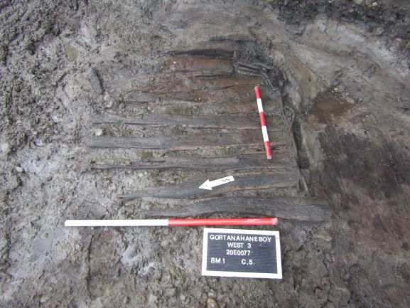
Burnt Mound 1 extended beyond the limit of excavation and had maximum exposed dimensions within the excavation area of 9.9m by 9.5m by 0.7m in thickness. It contained four deposits of heat-shattered stones in charcoal-enriched soil matrices and was truncated by a wood-lined drain and a field boundary ditch which extended along the entirety of the mound from north-west through to south-east. The mound was also cut in the south-western extent by a stone-lined drain which fed into a later field boundary ditch. A plank-lined and wattle-lined trough, which was also truncated by the ditch, was revealed beneath the mound. What remained of the trough was sub-rectangular in plan, measured 1.14m by 0.84m by 0.08m in depth and contained two fills. The trough construct comprised a minimal first lining of two timber planks, overlain by the main timber lining of twelve planks at the base. None of the surviving planks were of their full length owing to the truncation from the ditch, but they were on average 0.1m in width by 0.04m in thickness. Overlaying the plank lining were the poorly preserved remains of a wattle lining consisting of nine roundwood rods, surviving to a maximum height of five rows woven around six roundwood sails with pencil-point cut ends. The rods were typically 20mm in thickness, while the sails ranged from 30mm to 50mm in thickness.
Burnt Mound 2 measured 12.95m by 5.05m and had a maximum thickness of 0.48m. It consisted of five deposits, two of which contained heat-shattered stones in charcoal-enriched soil matrices and three of which contained frequent to occasional charcoal. No subsoil-cut features were found beneath this burnt mound.
Two burnt spreads were revealed near the northern and eastern limits of excavation. Neither spread had any subsoil-cut features discovered beneath them. The first consisted of a single deposit of dark blackish-brown silty clay, with moderate heat-shattered sandstone and frequent charcoal. It was amorphous in plan and measured 1.78m by 1.28m by 0.04m in depth. The second comprised dark blackish -brown silty clay with frequent heat-shattered sandstone and frequent charcoal. It was sub-oval in plan and measured 1.16m by 0.94m by 0.05m in depth.
No artefacts were recovered from the excavations at the site. In the absence of absolute dating, given the nature of the site type, it would not be unreasonable to suggest a possible Bronze Age date for the archaeology at Gortanahaneboy West 3.
Post-excavation analysis is ongoing and it is hoped that specialist reports, including radiocarbon dating and comparative research, will further enhance our understanding of the site.