2020:332 - GORTANAHANEBOY EAST (2 & 3), Kerry
County: Kerry
Site name: GORTANAHANEBOY EAST (2 & 3)
Sites and Monuments Record No.: N/A
Licence number: 20E0073
Author: Tony Bartlett
Author/Organisation Address: Archaeological Management Solutions Ltd, Fahy’s Road, Kilrush, Co. Clare
Site type: Forge and Road - road/trackway
Period/Dating: Modern (AD 1750-AD 2000)
ITM: E 511690m, N 591653m
Latitude, Longitude (decimal degrees): 52.069774, -9.288117
Stage (iii) Excavation was carried out between 6 July and 14 August 2020 the site of Gortanahaneboy East 2 & 3 in advance of construction of the N72 Stagmount Bends Road Improvement Scheme, Co. Kerry. The work was carried out under Licence Numbers 20E0073 (Excavation) and 20R0020 (Metal Detection), on behalf of Kerry County Council. The site was discovered in the east of the scheme in the townlands of Gortanahaneboy East and Gortanahaneboy West (the excavation area of Gortanahaneboy East 2 straddled both townlands) during advance Stage (i) Test Excavations undertaken in 2019 by AMS.
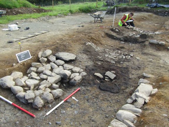
The site of Gortanahaneboy East 2 & 3 comprised two physically separate, but archaeologically related, Stage (iii) excavation areas. Gortanahaneboy East 2 consisted of a levelled eighteenth-century forge with metalled surfaces and evidence of ironworking, a field boundary bank and ditch, and a series of field drains. Gortanahaneboy East 3 consisted of a portion of an eighteenth-century ‘turnpike road’.
Gortanahaneboy East 2 comprised five phases of activity. The earliest two phases consisted of several pre-building agricultural features truncated by the forge structure. Phases 1 and 2 comprised a series of field drains and a field boundary drainage ditch. The field boundary bank comprised three deposits and two stone revetment facings, and measured 2.7m in width at its base by 1.95m in height.
Phase 3 comprised the foundations of the forge structure, constructed within the silted-up field boundary ditch. The initial construction entailed the excavation of a rectangular cutting creating a ‘sunken’ floor with internal dimensions of 6.35m in length (east-north-easst/west-south-west) by 2.6m in width by 0.3m in depth. This cutting was absent at the eastern end of the structure which may have been open and held the entrance to the forge. A single post-hole cut into the floor at its north-west corner may have held a post that formed a roof-supporting element, or which may have been part of a bellows construction. The southern and western limits were represented by the basal remains of stone walls, while the lack of a similar wall in the north is due to the northern side having been defined by the stone revetment of the field boundary bank. The stone foundations of a furnace were found against this northern limit and measured 1.54m in length by 1.34m in width by 0.3m in height. A rough stone setting abutting the south-east side of the furnace base, surrounded by a smithing pan, formed a pad base for a former wooden block upon which the anvil would have been positioned. Two metalled surfaces were recorded: one internal, the other external. The internal surface was sub-oval in plan, measured 2.6m in length by 1.7m in width by 0.1m in depth and was overlain by a charcoal-rich deposit which contained frequent slag. The external surface was sub-oval in plan, measured 1.6m in length by 1.6m in width by 0.1m in depth and was overlain by two deposits. The internal surface most likely defined a working area inside the forge, while the external surface may represent an area for shodding horses.
Phase 4 represented the demolition or collapse of the forge structure and comprised a single charcoal-rich deposit located across the main part of the forge floor, possibly representing the burned remains of a collapsed roof. Phase 5 comprised four post-abandonment, naturally accumulated deposits.
Gortanahaneboy East 3 comprised a portion of a turnpike road that represents a section of ‘The Butter Road’ also known as the ‘Straight Road’ or the ‘Old Kerry Road’, which was built in 1748 to link Cork-Millstreet-Castleisland-Listowel, with a branch to Killarney. What remained of the road consisted of a poorly preserved metalled surface and flanking boundary ditches. The stone surface survived for a length of 5.5m within the excavation area, with a width of 6.3m and a depth of 0.15m.
Artefacts recovered from the excavations at Gortanahaneboy East 2, including post-medieval pottery sherds, clay pipe fragments and bottle glass, date to the latter half of the eighteenth century to the first half of the nineteenth century (Eve Campbell pers. comm.) Objects relating to the workings of the forge were also recovered, including iron nails, an iron horseshoe and a large assemblage of metallurgical waste related to the smithing process. No artefacts were recovered from the turnpike road excavation at Gortanahaneboy East 3.