2020:220 - DOIRE FHIONÁIN MÓR, Kerry
County: Kerry
Site name: DOIRE FHIONÁIN MÓR
Sites and Monuments Record No.: KE106-073; -073001
Licence number: 18E0657 ext.
Author: Laurence Dunne
Author/Organisation Address: 3 Lios na Lohart, Ballyvelly, Tralee Co. Kerry
Site type: Ringfort - cashel
Period/Dating: Early Medieval (AD 400-AD 1099)
ITM: E 452684m, N 558789m
Latitude, Longitude (decimal degrees): 51.762019, -10.134227
Phase 3 of archaeological works at Derrynane cashel took place in September/October 2020. For clarity sake the numbering of the cuttings excavated in Phase 3 is sequential to the five previous cuttings completed in 2019 (Dunne 2019b). Phase 3 comprised the excavation of four cuttings (Cuttings 6–9).
Cutting 6 was opened through the current ad hoc entrance gap at the south-east to determine the existence of any sub-surface remains of the original early entrance of the cashel. It revealed the outer and inner walling of the southern limits of the enclosing wall, and at the same time establishing that the original entrance was not located here. The maximum exposed height of the relict wall was 0.6m and extended for c.1.3m. Excavation of Cutting 6 revealed also that the steeply sloping bedrock had been modified in a few places to keep the masonry from slipping. Cutting 7 was opened on the exterior downslope of the O’Connell adapted area of the cashel to determine the existence of any sub-surface remains of the ‘O’Connell phase’ of activity relating to the exterior wall niche (Dunne 2019). The excavated depth of the material varied from c.1m to a maximum 1.3m. With the exception of a few 18th–19th-century bottle fragments, the fill was sterile. Removal of the fill exposed uneven, steep bedrock. Cleaning of the bedrock revealed tool marks on its almost vertical face reflecting quarrying operations. The tool marks are most likely from a heavy metal quarrying bar. The bedrock here splits easily and would have been a convenient source of stone for the cashel. The quarrying activity is currently interpreted as relating to the later O’Connell phase/adaptation of the caiseal.
Cutting 8 comprises of the careful removal of scrub vegetation along with a narrow slot following the uppermost limits of the outer edge of the cashel wall exposing its topmost limits in the eastern quadrant. Here a section of the outer course of the wall was exposed for a distance of 3m and a maximum height of 0.45m terminating at a large blocky stone. This cutting established that the uppermost relict remains of the cashel had been adapted and assimilated as a possible viewing platform by the O’Connells.
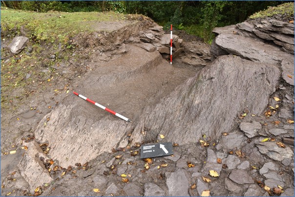
Cutting 9 was opened just north of Cutting 8 as Cutting 8 had revealed a coherent curvilinear section of the outer facing stones of the cashel wall reflecting the highest original masonry of the monument. Further cleaning to the north of this inner walling revealed that the walling ended on top of a large horizontal slab which was laid on modified bedrock. Furthermore, its short end abutted a similar sized large stone together forming a coherent right-angle turn. These two large stones matched up on plan with a large upright slab previously recorded on the outside of the cashel in Phase 1 (Dunne 2019a) which together strongly indicated the location of the possible original entrance. The features of the original cashel entrance discovered within Cutting 9 comprised of: (1) southern end of the entrance wall; (2) northern end of the entrance wall and (3) modified bedrock. The southern side wall of the entrance is very well constructed of large stone slabs laid directly on the bedrock. Six courses forming a total height of c.1m was exposed. The full height of the southern side wall of the entrance, including bedrock, measured c.1.35m.
Only a short section of the northern side wall of the cashel entrance survived in situ otherwise the remainder of the interior northern side comprised of a carefully modified curved platform of bedrock that would have originally formed the foundation for the upper walling. The surviving in situ section of the northern side walling abutting the bedrock is a maximum 0.8m high.
Modified bedrock extending for c.3.5m x 2.8m was exposed in the interior of Cutting 9 in between the newly discovered cashel entrance sidewalls. Of particular interest is the curving, crescent-shaped edge, c.0.2m high, that forms a level sweeping platform for the northern sidewall of the entranceway. The upper surface of all the modified bedrock is distinctively and deliberately pock marked creating grip marks underfoot.
With the exception of a possible sharpening stone fragment from Cutting 9 and a few fragments of glass bottle (18/19th century) in Cutting 7 no finds were recovered during Phase 3 works.
References
Dunne, L. (2019a). Derrynane More Caiseal, KE106-073, Archaeological Survey-Phase 1 Results, Derrynane National Historic Park, Caherdaniel, Co. Kerry. Unpublished Report Laurence Dunne Archaeology.
Dunne, L. (2019b). Derrynane More Caiseal, KE106-073, Archaeological Survey-Phase 2 Results, Derrynane National Historic Park, Caherdaniel, Co. Kerry. Unpublished Report Laurence Dunne Archaeology.