2020:824 - Dunkellin Flood Relief Scheme (Dunkellin), Galway
County: Galway
Site name: Dunkellin Flood Relief Scheme (Dunkellin)
Sites and Monuments Record No.: N/A
Licence number: 20E407
Author: Dominic Delany
Author/Organisation Address: Dominic Delany & Associates, Creganna, Oranmore, Co. Galway
Site type: Cemetery
Period/Dating: Late Medieval (AD 1100-AD 1599)
ITM: E 544232m, N 718436m
Latitude, Longitude (decimal degrees): 53.213413, -8.834938
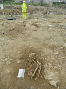
A small cemetery containing the skeletal remains of a minimum of sixteen individuals was excavated on the south bank of the Dunkellin River, c.50m upstream of Dunkellin Bridge, in July/August 2020. The excavation was undertaken as part of the archaeological mitigation for the Dunkellin Flood Relief Scheme, following the discovery of human remains during topsoil strip at the site in mid-July (2020:823). The burials were located in rocky ground, just below the field surface, resulting in many of bones being crushed and fragmented. There was evidence of previous ground disturbance in the area, possibly a result of works associated with the ‘Dunkellin Drainage Works’ carried out in the mid-19th century, or perhaps more recent agricultural activity. The burials were placed in shallow graves, the presence of rock/boulders frequently determining the depth at which the burials were inserted. Ground conditions meant the level of preservation of the skeletal remains was generally poor.
The cemetery displayed a variety of burial practices; the majority are extended inhumations, orientated with the head to the west, but there were also three crouched inhumations (two being juveniles), two double burials, and a prone burial. The burials consisted of seven adults, two adolescents, two juveniles, three young juveniles and two infants, indicating this is a communal burial ground. The absence of any older adults (45+ years) suggests this community did not experience longevity. The only artefacts recovered during the excavation were a possible iron buckle from the pelvic area of the prone burial, and three copper alloy wire rings with twisted terminals from the right side of the torso of an extended female burial. Radiocarbon dating places four of the burials in the mid-16th century while a fifth returned a later, mid-17th-century date.
It is suggested the cemetery may be associated with the small settlement cluster (GA103-120001) located between the castle (GA103-120002) and church (GA103-120003) on the south-west side of the bridge. An early medieval cashel (GA103-102) and inauguration site (GA103-102001) on the opposite, north bank of the river, indicate this was a place of considerable importance from an early period. Although the existing bridge at Dunkellin dates from the 17th/18th century, it very likely occupies the site of an important early fording point on the river.