2020:664 - SWORDS: Horizon Site N, Merryfalls and Silloge, St Margaret's, Dublin
County: Dublin
Site name: SWORDS: Horizon Site N, Merryfalls and Silloge, St Margaret's
Sites and Monuments Record No.: DU014-123; DU014-021
Licence number: 19E0177
Author: Muireann Ní Cheallacháin & Faith Bailey, c/o IAC Archaeology Ltd.
Author/Organisation Address: Unit G1 Network Enterprise Park, Kilcoole, Co. Wicklow
Site type: Burnt mound, Pit and Enclosure
Period/Dating: Multi-period
ITM: E 714014m, N 741927m
Latitude, Longitude (decimal degrees): 53.415134, -6.284902
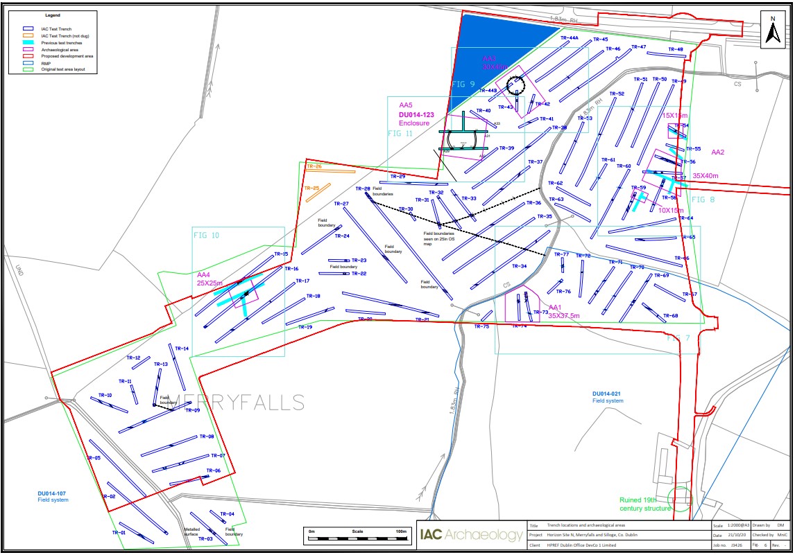
A programme of archaeological testing was carried out over the course of 13 days from April 23 to May 10 2019, at Horizon Site N (Merryfalls and Silloge), Swords, Co. Dublin. A total of 75 trenches were excavated by machine and short portions of seven of the trenches were hand dug. The trenches targeted the zone of archaeological potential for recorded monument DU014-021, the assumed north-eastern extent of a possible field system recorded as DU014-107, a circular anomaly identified from aerial photography, geophysical anomalies and open green space.
The topsoil across the site consisted of a mid- to dark brown clayey silt and ranged in depth from 0.28m to 0.5m. A light yellowish-brown clayey silt plough-soil was present in a number of the trenches and ranged in depth from 0.05m to 0.25m. The natural subsoil across the site consisted of a variety of sandy clays and clayey sands ranging in colour from light yellowish-brown to grey with occasional patches of coarse dark grey gravels.
Testing revealed four areas of archaeological significance, which have been designated as Archaeological Areas 1–4.
AA1 consists of a two small possible prehistoric burnt mound spreads adjacent to a stream within a field boundary ditch, with four associated pits which may be interpreted as possible troughs.
AA2 comprises an undated, sub-rectangular enclosure with associated ditches that is positioned within an early medieval and medieval landscape, which includes the ringfort (DU014-123) and the possible medieval field system (DU014-021).
AA3 consists of a circular enclosure with a diameter of 17.5m. The small diameter and shallow nature of the enclosing ditch suggest that it is potentially a ring ditch or barrow of possibly prehistoric date. No dating evidence or indication of burial was retrieved from the test trenches. Two linear ditches located directly to the south of the enclosure may be associated.
AA4 consists of an extensively robbed-out structure of post-medieval date.
AA5 consists of a 30m diameter enclosure that may represent the remains of a truncated early medieval ringfort (DU014-123). This site was identified in a previous programme of testing during 2010.
Testing within the zone of archaeological potential for recorded monument DU014-021, a possible medieval field system, revealed that the ridge and furrow first identified from a 1971 aerial photograph and visible in a 2017 Google Earth image, has been levelled by ploughing activity.