2020:663 - DUBLIN: 3-8 Hume Street, Dublin
County: Dublin
Site name: DUBLIN: 3-8 Hume Street
Sites and Monuments Record No.: N/A
Licence number: 19E0406
Author: David McIlreavy & Chris Coffey, c/o IAC Archaeology Ltd.
Author/Organisation Address: Unit G1 Network Enterprise Park, Kilcoole, Co. Wicklow
Site type: Structure
Period/Dating: Modern (AD 1750-AD 2000)
ITM: E 716233m, N 733334m
Latitude, Longitude (decimal degrees): 53.337462, -6.254698
A programme of archaeological monitoring was undertaken at Nos 3–8 Hume Street, Dublin 2, between 1 and 12 June, 2019, in response to planning conditions attached to the development. It followed a previous archaeological assessment carried out by Grace Corbett in May 2019.
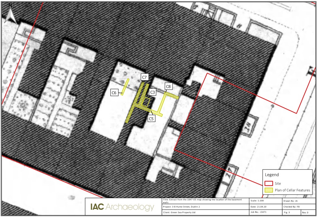
Overburden across the development area was removed to a depth of c. 1.8m. This revealed the fragmented remains of post-medieval basement structures to the rear of 6 and 7 Hume Street. Due to heavy disturbance as a result of development of the area in the 19th and 20th centuries, these remains were located exclusively in the northern part of the site.
In total, four truncated walls were recorded. These were predominantly limestone in fabric to east and south, with the westernmost being red-brick built (C6) and retaining a small collapsed portion of the former arch, which would have bridged the cellar to the west. The southern and easternmost limestone walls also incorporated what appeared to be termini of a red-brick wall that would have originally spanned between these two larger limestone walls. The central block was found to comprise two parallel limestone-built walls (C7) separated by a band of natural clay, perhaps indicating the property delineation between cellars. Similarly, the eastern limestone wall (C8) was flanked on its eastern side by sterile natural clay and therefore represents the terminus of this complex. C5 consisted of the remains of a wall to the rear (south) and C7 and C8.
On clean-back, a domestic cesspit (C3) was uncovered within the confines of the central and eastern wall portions (surrounded by C7, C8 and C5). The top of this feature was already below the required formation level so it was recorded in situ, with a single sondage excavated into the south-east quadrant. It was found to be limestone-lined in its southern extent, with a wooden slat base. Several sherds of pottery retrieved from the sondage dated the feature to the late post-medieval period.
Based on the results of the monitoring, it is clear that a basement level existed beneath the return associated with No. 7 Hume Street, as shown within the historic Ordnance Survey maps dating from 1847. It also appears that a basement level existed to the rear of No. 6 Hume Street, although the remains extend to the east from the building return marked within the historic mapping.