2020:614 - POOLBEG, Pigeon House Road, Dublin
County: Dublin
Site name: POOLBEG, Pigeon House Road
Sites and Monuments Record No.: DU019-029002
Licence number: 19E0654
Author: Siobhán Deery
Author/Organisation Address: Lynwood House, Ballinteer Road, Dublin 16
Site type: Sea wall
Period/Dating: Modern (AD 1750-AD 2000)
ITM: E 720637m, N 733805m
Latitude, Longitude (decimal degrees): 53.340708, -6.188426
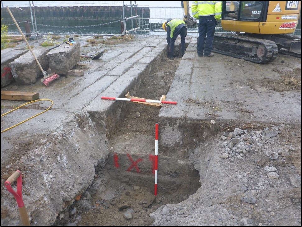
Archaeological monitoring was carried out of groundworks at the Poolbeg Tank Farm site drainage tie-in to the Rathmines Sewer. A section of the original revetment and inner and outer walls of the South Sea Wall were removed under archaeological supervision to accommodate a pipeline. Following the insertion of the pipeline, the revetment and walls were reinstated.
Prior to the commencement of groundworks the on-site vegetation was cleaned off, five rows of stones were numbered and fencing was erected. A mini-digger on rubber tracks and fitted with a jackhammer was used to break concrete along the line of the pipeline. Concrete grouting and concrete from the surface of some slabs was also removed by hand using bolsters and deeper grout was cut with a consaw. Concrete over the sewer was broken out to depth of approximately 0.4m. The line of the pipeline was cut and the remaining depth was broken out by hand with a jackhammer to reveal yellow sand beneath.
The quay wall is described as a double stone wall varying from 11m to 14m in width with the space in between filled with sand and built from large granite blocks bonded by cement and fastened with iron cramps (De Courcy 1996). The surface of the pier at the point of this development was 13.17m wide. It was built in two sections with three parallel walls: an outer sea wall with a paved surface, an inner quay wall that is 7.53m in width and an inner revetment with a concrete surface and a containing wall, 5.64m in width.
A single line of granite blocks on the south side of the Rathmines sewer formed the outer wall. It comprised alternating large and small blocks with a stepped layout on the north side. The large blocks measured 0.8m x 0.9m x 0.9m and the small blocks measured 0.5m x 0.6m x 0.9m. The paving was supported at either end by large granite block walls, 0.65m in width, and by a ballast of hydraulic fill consisting of brown fine to coarse sandy gravel with numerous rounded and slightly angled cobbles of varying size.
The quay wall comprised long granite blocks. The blocks were up to 2.5m long, were on average 0.3m wide and 0.45m deep. They were laid from north to south. Beneath the surface layer of slabs, the southern side of the wall was constructed of slabs of the same dimensions and laid from east to west. The core of the wall was filled with sand. The surface stones were lifted from south to north using slings and stored adjacent to the work area.
The inner revetment wall was topped with shaped granite stone that was laid in such a way as to produce a crenelated effect, alternatively 0.92m and 0.61m in width. The decorated stone was supported by a large block wall, only slightly visible. The iron cramps mentioned by De Courcy (1996) were not encountered within the line of the pipeline.
A number of modifications of the original design were required during excavation work and an amended method statement was submitted to the National Monuments Service and to Dublin City Council. It was originally proposed to core drill the outer sea wall. This was changed to the insertion of a cut and cover slot trench because of the difficulty of establishing an anchor point for the core drill. The top of the Rathmines sewer line, which runs close to and parallel to the revetment wall of the pier, was less than one meter below the existing concrete surface. As a result, the depth of the open trench was reduced from 1.3m to 1m.
Finally, the width of the trench in the paved section of the pier was also reduced, during excavation, from a proposed 0.75m to 0.65m. This resulted in only two lines of the granite paving slabs having to be lifted to excavate the open trench. The pier was reinstated with the paving slabs in their original position and with a new concrete surface over the Rathmines sewer line and the inner revetment section of the pier.
No other features of archaeological significance were observed during the monitoring works.
Reference
De Courcy, J.W. 1996. The Liffey in Dublin. Gill and Macmillan Ltd., Dublin.