2020:561 - DUBLIN 6: Clonskeagh Paper Mills, Clonskeagh Road, Dublin
County: Dublin
Site name: DUBLIN 6: Clonskeagh Paper Mills, Clonskeagh Road
Sites and Monuments Record No.: N/A
Licence number: 16E0358
Author: Yolande O'Brien, Courtney Deery Heritage Consultancy Ltd.
Author/Organisation Address: Lynwood House, Ballinteer Road, Dublin 16, D16 H9V6
Site type: Industrial site
Period/Dating: Modern (AD 1750-AD 2000)
ITM: E 717427m, N 730797m
Latitude, Longitude (decimal degrees): 53.314409, -6.237718
An archaeological impact assessment was carried out at Clonskeagh Paper mills by Mark Moraghan in compliance with a planning condition (Planning Ref. 2620/14; 2308/16; ABP PL 29S.247062). This was followed by archaeological monitoring of phased ground reduction by Mark Moraghan, Claire Cotter, Stephen Hickey, Siobhán Deery, Red Tobin and Peter Kerins between 2017 and 2020.
The site incorporates the site of the former Clonskeagh Paper Mills facility which ceased operation some years ago. It is bounded by the River Dodder to the east, Clonskeagh Road to the west, Clonskeagh Bridge to the south-west, and includes numbers 59-73 & 103, Clonskeagh Road, Dublin 6. The assessment was carried out after the standing buildings (all exclusively mid-20th century in date built upon a concrete ground slab) were demolished. The assessment comprised of archaeological monitoring of five site investigation pits concentrated around the perimeter of the site and six additional trenches added for archaeological purposes which were carried out alongside the site investigation works.
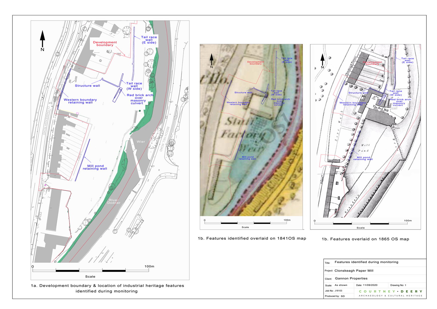
Elements of the former 19th-century water powered mills (indicated as ‘Iron works’, ‘Red Mills’ or ‘Stuff mill’ on cartographic sources) on site can be divided into three distinct areas: the northern area which once formed the headrace of the mill and diverted water from the River Dodder into the wheel pit within the main mill structure, the central area where all the main mill structures were placed, and the southernmost mill pond and mill dam area. The central area (main mill building area) could not be assessed due to the presence of reinforced concrete slab and demolition spoil heaps.
Test trenches in the northern (headrace) area revealed a rubble stone wall with an estimated length of 21m north-south. This wall runs along the same alignment as the eastern side of the headrace of the mill as shown on the 1865 map; it is likely to represent the retaining wall of the headrace channel.
In the southern area (mill pond and dam area), waste material (clinker, ash, sand and slag) was identified which is likely to be associated with the former iron works on site. These were identified within the reclaimed land associated with the millpond and mill dam areas of the site and were likely dumped waste material reused to infill these areas.
The archaeological monitoring during the enabling works for the site, comprising concrete slab removal and removal of contaminants, revealed truncated masonry remains which included:
• the tail race wall at the northern end of the site (eastern wall),
• tail race (western wall),
• retaining wall and mill race culvert, which included the remnants of the red brick arch and masonry pier,
• remnant of the northernmost mill structure shown on the first and revised OS map (northern wall),
• roadside retaining wall,
• a stretch of the mill pond western retaining wall.
These were associated with the stuff factory shown on the 1841 Ordnance Survey map, but it is highly probable that some features were earlier than this given the tradition of milling from the medieval period on the River Dodder. For the most part however it was found that the former milling structures were removed by the modern paper mill. The features identified were investigated and recorded and the areas where they were found were then backfilled and built back up as they were at a level that is below the formation level for the development (which will be founded on piled foundations).
The enabling works have been completed and no further archaeological works are considered necessary at the site.