2020:482 - NEWCASTLE: Newcastle South, Dublin
County: Dublin
Site name: NEWCASTLE: Newcastle South
Sites and Monuments Record No.: N/A
Licence number: 19E0116
Author: David Bayley & Fergal Murtagh, c/o IAC Ltd.
Author/Organisation Address: Unit G1 Network Enterprise Park, Kilcoole, Co. Wicklow
Site type: Kiln and Pit
Period/Dating: Multi-period
ITM: E 700092m, N 728633m
Latitude, Longitude (decimal degrees): 53.298527, -6.498449
Excavations at Newcastle South follow on from a programme of testing undertaken in February 2019 also under licence 19E0116 which followed on from geophysical survey carried out in 2018 (18R0042) by IAC Archaeology. Seven trenches were excavated across the site and identified one area of archaeological potential consisting of charcoal-rich pits and three linear features which were identified within Trenches 1 and 2 within three smaller sub-areas.
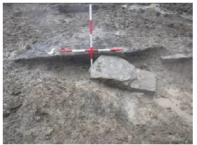
Excavations consisted of three separate cuttings, designated Cuttings A–C. Cutting A contained evidence of probable industrial activity in the form of a kiln (C4) and a curvilinear slot trench (C6) towards the south of the cutting. The kiln was interpreted as having served as a cereal-drying kiln (Plate 1). The curvilinear slot trench was located immediately to the south of the kiln and probably formed a wind-break type structure that provided shelter for the kiln. A deposit/dump of charcoal-rich silty clay, most likely waste material from the kiln, was recorded in the northern part of the cutting.
In Cutting B, a roughly north-south oriented linear gully (C14), possibly a drainage feature, and a roughly north-north-east/south-south-west oriented agricultural furrow (C24) were the only features identified. The gully was shown to be the stratigraphically earlier of the two features, as the furrow cut the gully at the point of intersection between the two. The furrow appeared to terminate just to the north of the intersection between the features.
An isolated pit (C31) was identified at the northern end of Cutting C. Due to the nature of the fills, it was interpreted as a waste pit. At the southern end of the cutting, a linear ditch (C8), interpreted as a sub-division of a burgage plot, and six agricultural furrows (C10, C12, C16, C18, C20 & C22), were recorded. One of the furrows cut across the ditch and other furrows were also intercutting, indicating at least two phases of activity. Nothing was recovered during the excavation to indicate a date for the activity .
The current interpretation of the phasing of the activity on site is based on stratigraphic relationships and typological similarities between features. It is hoped that post-excavation analysis will further inform the preliminary interpretation of the activity on site.