2020:476 - Former Enterprise Centre, Newmarket Square, The Liberties, Dublin 8, Dublin
County: Dublin
Site name: Former Enterprise Centre, Newmarket Square, The Liberties, Dublin 8
Sites and Monuments Record No.: N/A
Licence number: 20E0113
Author: Paul Duffy
Author/Organisation Address: c/o IAC Ltd, Unit G1 Network Enterprise Park, Kilcoole, Co. Wicklow
Site type: Urban
Period/Dating: —
ITM: E 714752m, N 733405m
Latitude, Longitude (decimal degrees): 53.338423, -6.276899
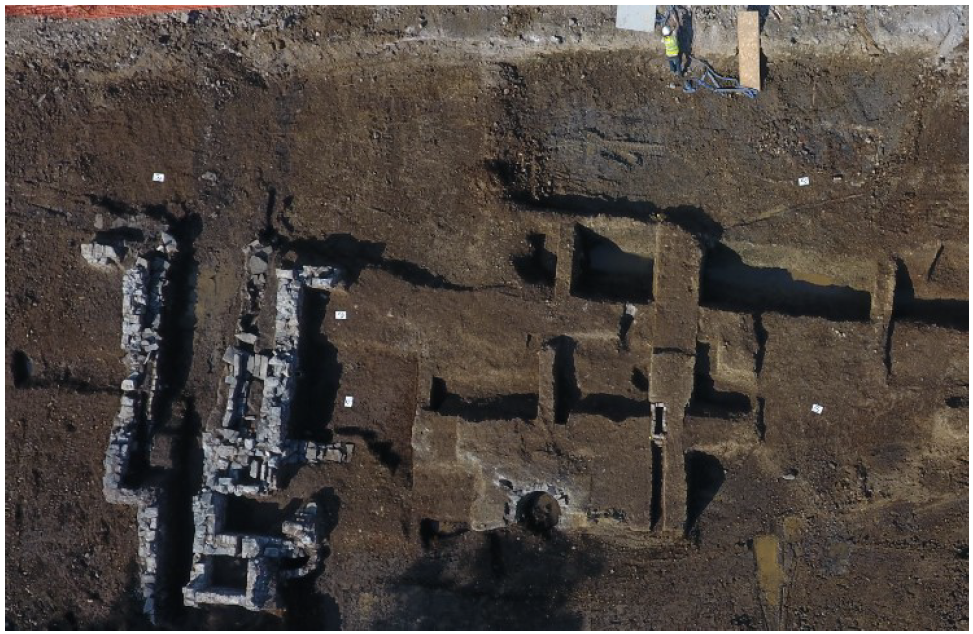
Archaeological excavation was undertaken at Newmarket Square, Dublin 8 on the site of former IDA lands. The site was bounded to the south by Newmarket, to the north by St Luke’s Avenue, to the west by Brabazon Row and to the east by Newmarket Lane. The works were undertaken in advance of the redevelopment of the site for mixed-use purposes. The site is located within the zone of Notification for the historic town of Dublin (DU018-020) and there are an additional 21 recorded monuments within a 150m radius.
The earliest phase onsite was represented by a tan-coloured relict soil that overlay the natural boulder clay and was sealed by later deposits of garden soils. This layer represents the original topsoil of a type regularly encountered in this area of Dublin.
Two large ditches of medieval date were uncovered during excavations. The first of these (C184) was substantial enough to suggest a defensive function, although the fact that it terminated without any clear sign of continuation suggests that it was intended more to present a barrier in the landscape, perhaps with a view to preventing the driving off of cattle or to block direct approach to an inhabited area such as the row of medieval house plots known to have existed at this time along Dean Street 170m to the north-east. This ditch is likely to date to the late 12th/13th century.
A large U-shaped ditch (C100) clearly corresponds to the boundary visible on the 1670s map of Newmarket which states that to the north of the boundary lay Church Lands while the Earl of Meath’s lands lay to the south. In effect, this ditch formed the boundary between the liberty of Donore and that of St Sepulchre. The later property boundaries that emerged following the laying out of Newmarket similarly respected the line of this ditch and its shape informed the size of the plots in the area up until the 20th century.
Plots dating from the late 17th/early 18th century development of the site have been identified to varying degrees and these match the lease maps where available. Towards the central southern portion of the site, fragmentary remains of the entrance to Fordham’s Alley were identified.
The plots in general consisted of shallow buildings without cellars fronting onto the square. The plots each contained a red brick cistern fed by timber water pipes fed from the mains pipe in Newmarket Square. There were many recurring features including cess pits and large shallow pits (possibly layaway pits for small-scale tanning). Small brick-built kilns or furnaces were identified in many of the plots. A large volume of 17th- and 18th-century ceramics were recovered from cess pits and wells. Some of the ceramic is early in date and seems to predate the establishment of Newmarket, suggesting some of the pits may predate the plots within which they are contained. Many copper-alloy finds, numerous leather shoes and a quantity of 17th- and 18th-century leather fragments were retrieved across the site.
In the south-west corner of the site, a late Victorian pub dating to the 1890s was demolished at the onset of the project. Investigation afforded by the demolition has shown that the pub was built on a pre-existing cellar that conforms in shape and size to that presumed to underly the building known as Matt White’s tavern.
Specialist input into the various artefacts and environmental assemblages will also shed light on the range of industrial and domestic functions that were undertaken across the site whilst also helping to flesh out the material culture that was common throughout the various phases.