2020:413 - CLONBURRIS LITTLE, Cappagh, Kishoge and Grange, Dublin
County: Dublin
Site name: CLONBURRIS LITTLE, Cappagh, Kishoge and Grange
Sites and Monuments Record No.: N/A
Licence number: 20E0390
Author: John Ó Néill
Author/Organisation Address: For Irish Archaeological Consultancy Ltd
Site type: Kiln - brick, Charcoal-making site and Field boundary
Period/Dating: Multi-period
ITM: E 705234m, N 732499m
Latitude, Longitude (decimal degrees): 53.332262, -6.420059
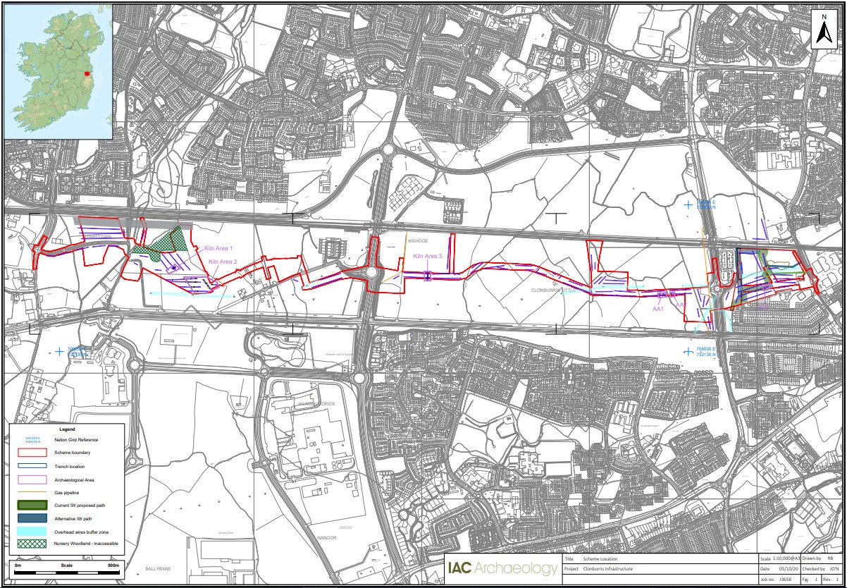
Testing was undertaken within the Clonburris Strategic Development Zone (SDZ) in the townlands of Clonburris Little, Cappagh, Kishoge and Grange, Dublin 22. The assessment incorporated a programme of metal-detecting under licence 20R0168.
Archaeological testing was carried out over the course of four weeks in August and September 2020. The trenches targeted open green space within the proposed infrastructure for the Clonburris SDZ identifying 6 areas of archaeological significance (AA1-AA6). These comprise evidence for brick manufacture (AA1, AA2 and AA3) and charcoal kilns and related activity (AA4, AA5 and AA6).
A total of 82 trenches were excavated across the site measuring 7,106 linear metres across five different townlands, which were (from west to east): Adamstown (Trenches 1–9 and Trench 101), Grange (Trenches 10–22), Kishoge (Trenches 23–33), Clonburris Little (Trenches 34–43) and Cappagh (44–82).
The topsoil was relatively consistent across the area investigated with between around 0.3m and 0.4m of mid-brown silty clay present. This overlay a series of compact clays, varying in colour from orange to grey, with some limestone bedrock in places. In some locations a grey-yellow fine silty clay was exposed when the topsoil was removed and found to be present to a depth of up to 0.2m overlying the subsoil. This appears to have a natural origin but was generally removed during testing to ensure it had not formed over the top of deposits of archaeological significance.
It should be noted that evidence for past agricultural activity across the whole site was not particularly intensive with little evidence for agricultural furrows. Attempts at land drainage were present in a number of locations but former farmers and landowners and others familiar with the area have indicated that the ground can be seasonally very wet. While the construction of the Grand Canal to the south in the 1760s and 1770s likely improved drainage, even subsequently the ground may often have been too marginal for many forms of agricultural activity. During testing, a limited assemblage of material was identified within the topsoil. Mainly this consisted of a very small number of sherds of nineteenth- and twentieth-century pottery, often cream wares, with very occasionally sherds of pottery such as Black Ware that may be eighteenth century in date. As farmhouse rubbish was generally retained in a midden which was scattered on fields as fertiliser, the limited manuring also suggested that the area had not been intensively farmed. Similarly there was a singular absence of any earlier artefactual evidence, or introduced and unmodified materials that would be indicative of the proximity of sustained human activity. This is borne out by the archaeological features identified in testing.
Most of the field boundaries in the area appear on the first edition Ordnance Survey maps and would appear, then, to pre-date the 1830s. The layout of the small demesne around Clonburris Cottage, in Clonburris Little townland, is clearly cut by the line of the Grand Canal and indicates that the field boundaries have their origins well before 1750.
AA1: Substantial evidence of previously unrecorded brick manufacture was found in Trench 14 and some of the surrounding trenches in the same field as Trench 14, in particular the south-eastern end of Trench 13. Trench 14 was widened to establish the full extent of the brick manufacturing and an area of 10m by 10m was identified. While a series of small structural features were identified within this area, it may represent a single large brick kiln and other similar structures may be present in the vicinity.
AA2: Further evidence of previously unrecorded brick manufacture was found in a number of trenches laid out beside each other in the field to the south of AA1. These included the eastern half of Trenches 17 to 20 and all of Trenches 21 and 22, within an irregular area measuring 150m by 150m.
AA3: Further evidence of previously unrecorded brick manufacture was found in Trenches 27 and 28 in Kishoge, in the fields just to the east of the R136.
AA4: Three pits, with evidence for burning and charcoal, were identified in Trench 55 in Cappagh just to the east of the R113.
AA5: A single large pit, capped in clay and containing charcoal, was identified in Trench 57 in Cappagh just to the east of the R113.
AA6: A single large pit, capped in clay and containing charcoal, was identified in Trench 68 in Cappagh in the fields to the west of the R113.
In Clonburris Little and Cappagh, a number of features exposed by the test trenches corresponded to field boundaries indicated on the first edition Ordnance Survey maps but no longer visible on the ground.
In Clonburris Little, the boundaries around Clonburris Cottage as indicated on early edition Ordnance Survey maps correspond to features noted in Trenches 42 and 43. These were collapsed limestone and brick walls incorporating significant amounts of modern debris. The suggestion, from the absence of references to the cottage on site in late eighteenth- and early nineteenth-century newspaper rental adverts, is that the cottage itself was, at the earliest, nineteenth century in date. There was nothing noted to suggest earlier activity at the site although, given the nature of the landscape, it is likely that buildings were constructed within the driest areas of the surrounding lands and so were the repeated focus of occupation over the years (making them the likely locations for in situ archaeological materials).
In Cappagh, in demesne lands to west of Cappagh House, Trenches 72 and 76 exposed linear boundary features that correspond to field boundaries indicated on earlier edition Ordnance Survey maps but that are no longer visible on the ground.