2020:355 - DUBLIN: George's Dock, Dublin
County: Dublin
Site name: DUBLIN: George's Dock
Sites and Monuments Record No.: DU018-020
Licence number: 20E0102
Author: Steve Hickey, c/o AMS
Author/Organisation Address: Fahy's Road, Kilrush, Co. Clare
Site type: No archaeology found
Period/Dating: N/A
ITM: E 716580m, N 734625m
Latitude, Longitude (decimal degrees): 53.348982, -6.249015
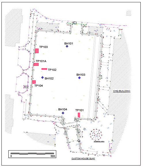
Archaeological monitoring of five trial pits and four boreholes was carried out in March 2020 at George’s Dock and Customs House Quay in Dublin 1 in advance of a proposed development. These works followed on from an Archaeological Assessment and Impact Assessment Report (Hickey, 2020).
The site, which encompasses a total area of c.2.18 acres, is the nineteenth-century George’s Dock and is located in the Dublin Docklands, close to the International Financial Services Centre. George’s Dock is listed on the Record of Protected Structures (RPS Ref. 3173) and the Dublin City Industrial Heritage Record (DCIHR Ref. 18 07 101).
Monitoring works recorded the results of five trial pits (TP101, TP101A, TP102. TP103, and TP104) and four boreholes (BH101–BH104). Due to the very substantial extent of modern build-up encountered across the site, none of the trial pits revealed archaeological layers earlier than the latter half of the nineteenth century. The ground level of this modern material is c.0.8m OD. The dock was drained to below this level at the time of the excavation works, however, 2 industrial pumps were required to clear in-rushing water during excavation of the trial pits. Four of the five trial pits were dug to the full reach of the mechanical excavator’s arm, reaching depths of between -2.7m OD and -3.2m OD.
A review of the borehole logs indicates that this modern material sits over natural boulder clay, which occurs at a depth of c.-4m OD. Only the northernmost borehole (BH101) showed the presence of a potential archaeological layer, a soft black sandy silt, appearing below modern material at -3.85m OD for a depth of 0.5m. This material sat above natural boulder clay present at a depth of -4.35m OD. The proposed formation level in this area will not exceed -1.8m OD.
A review of the proposed development works has been carried out and recommendations for further monitoring have been made.