2020:277 - TRINITY COLLEGE DUBLIN: E3 Learning Foundry DP2, Dublin
County: Dublin
Site name: TRINITY COLLEGE DUBLIN: E3 Learning Foundry DP2
Sites and Monuments Record No.: DU18-020
Licence number: 20E0615
Author: Judith Carroll, Judith Carroll and Company
Author/Organisation Address: Ballybrack Road, Glencullen, Dublin 18
Site type: Urban
Period/Dating: —
ITM: E 716551m, N 734032m
Latitude, Longitude (decimal degrees): 53.343662, -6.249669
Archaeological monitoring and excavation took place on the site of the E3 Learning Foundry, Trinity College Dublin, from 19 October 2020 when digging works for drainage commenced on the site. The development site is close to the Pearse Street entrance to TCD in the area of the science blocks, including the Roberts laboratory, Anatomy building and Hamilton building. In the Parade Ground between the blocks, a drainage line was being updated as part of the development.
A stone and brick wall was located by the contractors below ground level during the digging of the drainage line. This was followed by a number of other walls and floor features. Further digging for the drain and manholes revealed seven areas of walls and features in total. Main excavation took place between 2–12 November 2020 with additional recording of wall features up to 18 December 2020.
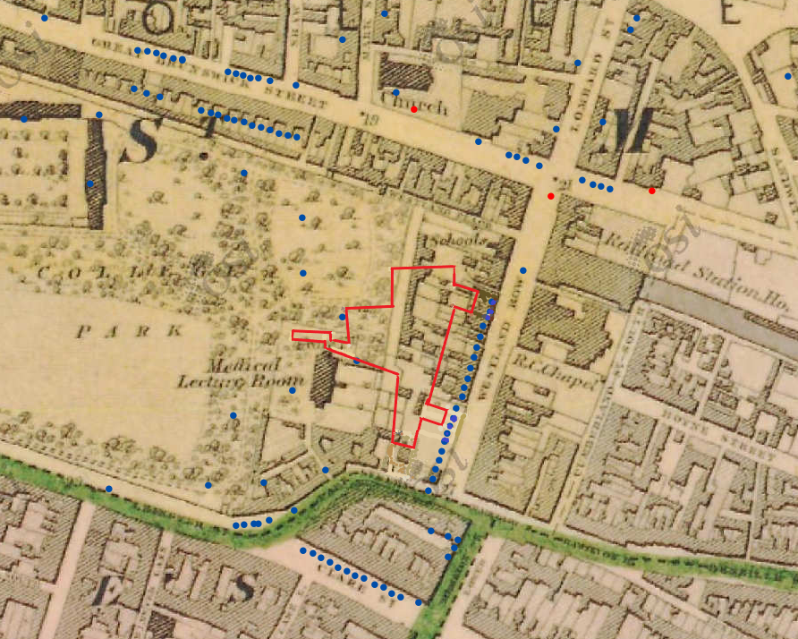
The features can be shown to relate to outhouse and wall structures which are shown on the 19th-century OSI maps. These outhouses and walls were located at the west end of rear gardens behind a row of houses of early 19th-century date. The house properties fronted onto Westland Row. The back area of the properties was purchased by Trinity College and the former extensive rear gardens/plots were developed as part of the college, forming the science blocks of today. They are currently occupied by the Hamilton Building and the Biotechnical Building as well as the Parade Ground (see the OSI six-inch map of 1839-46 and the OSI 25 inch map of the 1880s).
The present modern science blocks on the Parade Ground in TCD were built on the former back gardens of the Westland Row houses which would have had stables, coach-houses and other outhouses. Such outhouses were typically at the end of such gardens. The location of the end of the former gardens is on the present Parade Ground which is being dug for drainage. That some of the ‘outhouse’ structures may have comprised mews dwellings is apparent on the earlier 19th-century map. It seems that most of these outhouses were removed and the property boundaries changed by the late 19th century.
The present development, though it is in the area of the early 19th-century gardens and outhouses, was quite close to the shoreline of the River Liffey. It was well outside the precincts of the medieval All Hallows and the early modern university boundary of Trinity. From the cartographic record, there are no houses on the site in 1756 (Rocque’s map) or earlier.

