2020:601 - NEWRY: Lisdrumliska, Watsons Road/Doran's Hill, Down
County: Down
Site name: NEWRY: Lisdrumliska, Watsons Road/Doran's Hill
Sites and Monuments Record No.: N/A
Licence number: AE/20/093
Author: Eoin Halpin
Author/Organisation Address: AHC Ltd 36 Ballywillwill Road, Castlewellan Co Down BT31 9LF
Site type: Field system
Period/Dating: Iron Age (800 BC-AD 339)
ITM: E 707576m, N 825407m
Latitude, Longitude (decimal degrees): 54.166353, -6.352575
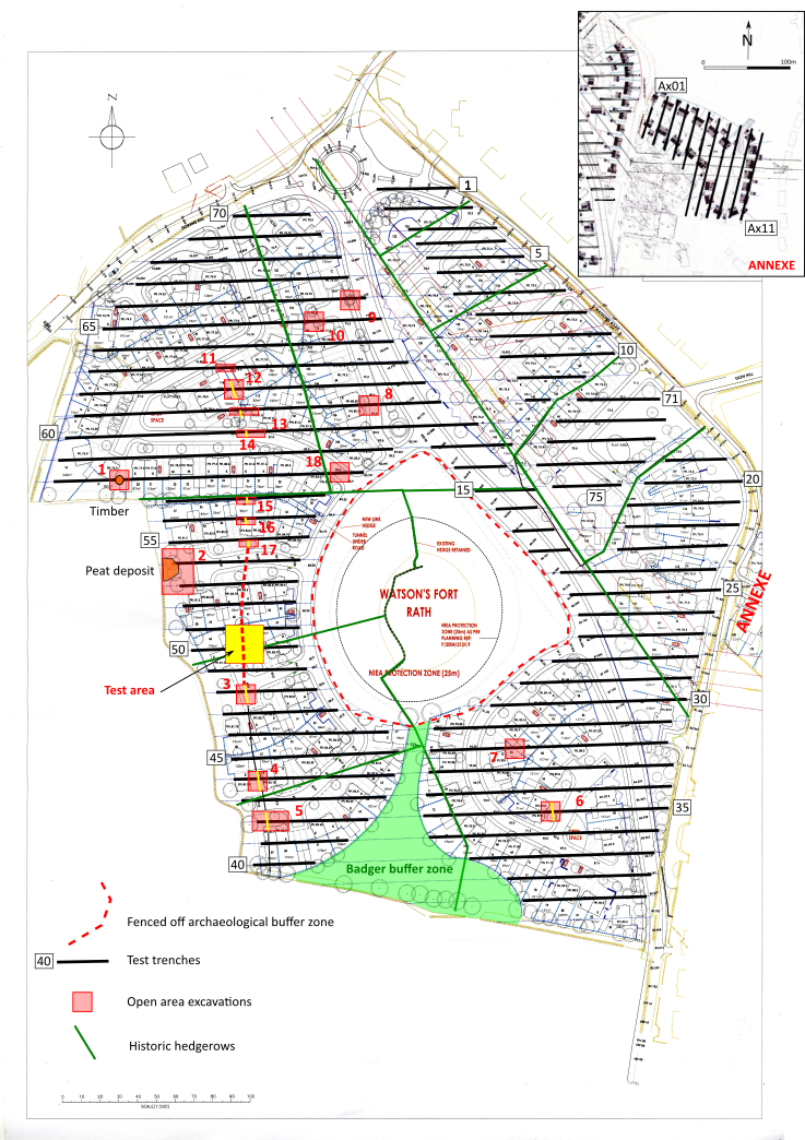
The initial archaeological testing phase took place over a 10-day period between 26 October and 10 November 2020. A total of 81 trenches were opened, 70 in the main area and a further 11 in the annex development area to the east, across Watson’s Road. Nothing of archaeological interest was noted in any of the 11 trenches opened in the Annex area.
Within the main site, 18 areas of archaeological interest were noted; these consisted of six areas where a linear feature was uncovered (Areas 3, 4, 5, 6, 9 and 12), four areas where apparently isolated pits or pit-like features were noted (Areas 7, 8, 10, and 18), an area of possible burnt mound material (Area 2) and a possible log boat which on investigation proved to be a naturally hollow tree trunk. Six further areas were opened (11, 13, 14, 15, 16 and 17) chasing the linear feature first uncovered in Area 12.
A series of 10m by 10m areas were opened up over all of the majority of areas, with the exception of Areas 2 and 5 where a 15m by 20m area was opened up to examine a larger area around the possible burnt mound deposit and a linear feature.
These areas were hand-excavated with a team of archaeologists, commencing on 16 November 2020, and ran until 25 November.
Two potential features of archaeological note were uncovered in the investigations, and both were linear in nature. The first was the U-shaped small ditch or gully, first noted in Area 12 at the northern end of the development area; this was traced southwards, across Areas 13, 14, 15, 16, 17 and 19. Although not certain, it is likely that the linear feature uncovered in Areas 3, 4 and 5, is also part of this feature. The fills along the length are similar, grey, gritty, sandy silts with the dimensions, some 1m in width and 400mm in depth, also similar in all the places it was investigated. The feature runs from north to south across the western slopes of the hillside on top of which the rath ARM026:013 is located. The feature is demonstrably earlier than the field boundaries noted on earlier maps of the area. The radiocarbon dates returned for samples of alder charcoal from the base of this linear feature in Area 4 returned a date of between 126 – 306 cal AD and from the base of the linear feature in Area 19 of between 356-107 cal BC, which places the ditch within the Iron Age, predating the generally accepted date for the construction of raths at between 600 and 900 AD (Stout 1997 p.29). The simplest explanation for the ditch is that it is agricultural in origin, probably a field boundary, which was laid out to subdivide the area around Doran’s Hill. The gap in the linear feature, noted in Area 19, might simply represent an opening from one field into another. No other features of a similar nature were uncovered anywhere else across the area tested. Such was the density and layout of the test trenches that any similar linear features would have been picked up. As it is highly unlikely that this ditch was originally laid out in isolation, it must be assumed that the remainder of the Iron Age filed system has been removed by more recent agricultural practices.
The other linear feature of note was uncovered in Area 6, to the south of the rath. It was a much more ephemeral feature, but in the field it was felt to be potentially significant as it clearly ran from north to south, potentially radiating out from the site of the rath, located some 80m to the north. The sample of hazel charcoal from this feature produced a 2 sigma date of 1457–1633 AD, that is sometime in the middle of the 16th century. Finds from the feature are likewise quite late, some suggesting a date of the 18th century.
The uncovering and investigation of a field boundary or land division dating to the Iron Age is significant and suggests the continuous settlement and use of the area around Doran’s Hill stretching back some 2 millennia. This feature was investigated across a number of separate cuttings and in two open areas and is considered resolved.
Due to the extent of the testing and associated open area excavations it is recommended that the development be allowed to proceed with out the requirement for further archaeological involvement.
Reference
Stout, M. 1997 The Irish Ringfort. Four Courts Press, Dublin.