2020:643 - CARNSHANNAGH (1), Donegal
County: Donegal
Site name: CARNSHANNAGH (1)
Sites and Monuments Record No.: DG062-024
Licence number: 20E0502 (and 20R0184)
Author: JAMES MCKEE, c/o Archaeological Management Solutions Ltd.
Author/Organisation Address: Fahy’s Road, Kilrush, Co. Clare
Site type: Habitation site
Period/Dating: Prehistoric (12700 BC-AD 400)
ITM: E 628684m, N 904366m
Latitude, Longitude (decimal degrees): 54.886256, -7.552953
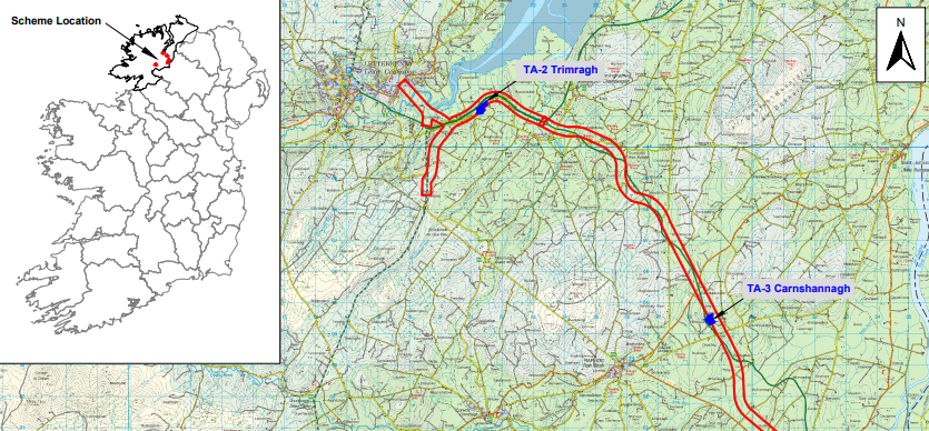
Stage (i)a Standard Test Excavations and Stage (i)h Metal Detection Surveys were undertaken in the townland of Carnshannagh as part of the Archaeological Consultancy Services Contract of the TEN-T Priority Route Improvement Project in Donegal. The TEN-T Priority Route Improvement Project is part of the Trans-European Transport Network and comprises the construction of three sections of new road:
Section 1: N15/N13 Ballybofey/Stranorlar Urban Region; Section 2: N56/N30 Letterkenny to Manorcunningham; and Section 3: N14 Manorcunningham to Lifford/Strabane/A5 link. Carnshannagh, in Section 3, is one of five Testing Areas (TAs) along the preferred route of the TEN-T project which require Stage (i)a Test Excavations and Stage (i)h Metal Detection Survey Services.
In total, 3,306m were test excavated at Trimragh representing a >12% sample of the greenfield area available for test excavations. These excavations targeted anomalies identified through previous geophysical and LiDAR surveys are the site; these surveys were themselves undertaken to assess RMP site DG062-024, one of five known monuments which could be impacted by the scheme.
During archaeological testing at Carnshannagh a cluster of features, likely representing a small prehistoric settlement/camp, was uncovered. These features included a minimum of five post-holes, seven stake-holes, eight pits (of indeterminate function) and a large burnt spread/deposit, based on initial assessment. Charred cereal (barley) from one of the pits produced a date of 1619–1454 cal. BC. A ditch and furrows were also recorded. Two further isolated pits were also recorded, located south-west of the main cluster, directly adjacent the preferred route corridor, as set out at the time of testing. Collectively the features indicate a small prehistoric settlement at the site, possibly dating to the Bronze Age or Neolithic. Seven pieces of worked quartz were recovered from the site, but only one from a secure context, indicating possible stone-work at the site. Stage (i)h Metal Detection surveys also recovered two artefacts, a coin and a lead waste piece, with a further single copper alloy fitting recovered from metal detection of the topsoil during archaeological testing.
The site at Carnshannagh may be adversely impacted upon by the scheme, pending the final design of the route within the preferred route corridor for the TEN-T road scheme. If the site cannot be avoided by the final design then the archaeology, as defined by archaeological testing, was recommended for full excavation and preservation by record.