2020:227 - CORK LINE LEVEL CROSSING PROJECT: XC215 Shinanagh: Ballynageragh & Imphrick, Ballyhea, Cork
County: Cork
Site name: CORK LINE LEVEL CROSSING PROJECT: XC215 Shinanagh: Ballynageragh & Imphrick, Ballyhea
Sites and Monuments Record No.: CO007-120002-, CO007-120001-
Licence number: 20E0639; 20R248
Author: Ian Russell, Archaeological Consultancy Services Unit
Author/Organisation Address: Unit 21, Boyne Business Park, Greenhills, Drogheda, Co Louth
Site type: Church, Graveyard, Earthwork, Pit and Burnt spread
Period/Dating: Multi-period
ITM: E 553525m, N 615060m
Latitude, Longitude (decimal degrees): 52.285247, -8.681172
A programme of Advance Targeted Archaeological Test Excavations was carried out in advance of the Cork Line Level Crossings Project: XC215 Shinanagh, Co. Cork ITM 553605, 615358 (N) to 553465, 614494 (S) in November 2020. The site is located within three large pasture fields, in the townland of Ballynageragh & Imphrick and its south extent is within the immediate environs of Church (CO007-120002-) with an associated Graveyard (CO007-120001-) and Ritual site – holy well (CO007-121—-).
The work was carried out on behalf of client to help inform the preparation of an Environmental Impact Assessment Report for the preferred route. Prior to the archaeological testing a Geophysical (Fluxgate Gradiometer) survey (Dowling 2020) and high resolution magnetic gradiometry (Nicholls 2020) was carried out under licence 20R0016. The anomalies identified in the course of geophysical survey of Field 1 were interpreted as associated with field divisions, while geophysical survey of Field 2 resulted in the identification of remnants of a probable field system/field divisions and archaeological remains in the south end of the field (Nicholls 2020). In Field 3 all anomalies identified represented linear features, including two now-removed boundaries and features identified as representing old field systems that possibly relate to the monuments located in the immediate environs. The test excavation strategy was designed to target these anomalies to determine if they represented archaeological features.
An assessment took place between 18 and 25 November 2020. A total of 20 test trenches were excavated across the footprint of the site using a 14-tonne tracked excavator fitted with a 1.8m-wide bucket. A total of 317m of linear test trench was excavated. Anomalies identified during the geophysical survey (20R0016) were targeted (Test Trenches 1-20). In general, the average thickness of the topsoil measured c. 0.3-0.6m and consisted of greyish brown sandy clay exposing natural, that varied between greyish-yellow sandy clay and pale orange grey marl.
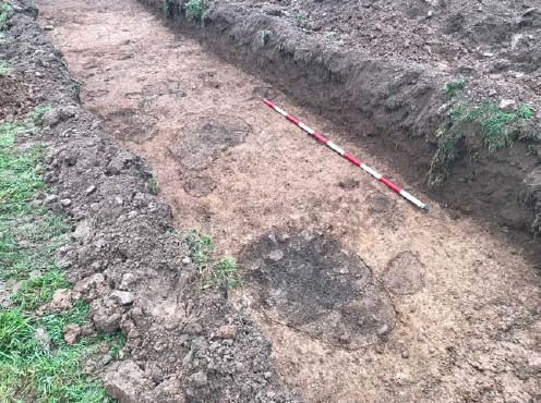
Three areas of archaeological activity were identified: in the north end of Field 1; in the south end of Field 2, and within Field 3. In the north extent of Field 1 a number of features of archaeological significance were exposed and comprised of pits, post-holes, linear features and ditches, all suggestive of settlement/archaeological activity within the site. While the fills of the features did not contain any datable finds, slag and vitrified material was retrieved and samples were taken.
The features located in the south end of Field 2 were identified during geophysical survey, and targeted test trenching confirmed their archaeological significance. The features exposed consisted of linear features, pits, ditches and spreads associated with metalworking with slag/vitrified material retrieved from both spreads and linear features.
In Field 3 a spread and a number of linear features/ditches were exposed, while these did not produce any datable material, and their linear nature and sterile fills are suggestive of field systems of unknown date, the location is in the immediate environs of the Church (CO007-120002-); an associated Graveyard (CO007-120001-) and Ritual site – holy well (CO007-121—-) therefore these may potentially be associated with the medieval landscape. Future, more extensive investigation will be required to determine their full extent and significance.
It appears that most of the remaining linear features identified throughout the site are consisted with anomalies identified in the geophysical survey and represent field divisions and/or former field boundaries as well as, in some cases, geological differences in the natural and/or changes in the topsoil, likely of recent date.
A number of environmental samples from the various features, including pit and ditch fills, were taken on site. Some of these produced charcoal and it is recommended that a number of these be submitted for radiocarbon dating in order to better understand the nature and dating of the features exposed. As the proposed Cork Line Level Crossings Project will require significant ground works, all identified features will be directly impacted. Full preservation by record (i.e. archaeological excavation) in advance of construction works commencing will therefore be required in order to mitigate this permanent impact. The possible presence of other smaller archaeological features along this route in the un-tested areas can not be dismissed; therefore it is recommended that the area is subject to more general test trenching throughout the full land take area in advance of construction works commencing. The particulars of any mitigation measures will be included in the Environmental Impact Assessment Report for the scheme.
References:
Dowling, G. 2020. Geophysical Survey Report of Lands at Ballynageragh & Imphrick, Co. Cork (20R0016). Unpublished report prepared by AMS.
Nichols, J. 2020. Geophysical Survey Report XC211 (Ballynageragh & Imphrick Townland) & XC215 (Shinanagh Townland), Cork Line Level Crossing Project, County Cork (20R0016 & 20R0017). Unpublished report prepared by AMS