2019:705 - WATERFORD: Public Realm phase 2ii, Waterford
County: Waterford
Site name: WATERFORD: Public Realm phase 2ii
Sites and Monuments Record No.: WA009-005
Licence number: E4487 (under C587)
Author: Orla Scully
Author/Organisation Address: 7 Bayview, Tramore Co. Waterford X91 X462
Site type: Historic town
Period/Dating: Multi-period
ITM: E 660264m, N 612200m
Latitude, Longitude (decimal degrees): 52.258204, -7.117260
The final phase of the Public Realm Works in Waterford City was concluded in 2019. The Streets included were Brown’s Lane, Castle Street, New Street and the southern ends of Stephen’s Street and Newgate Street.
The Anglo-Norman mural tower known as the French Tower is located at the southern end of Brown’s Lane. A trench circumnavigating the south-western base of the tower was excavated prior to the laying of a new pathway. Significantly, no traces of the erstwhile wall which extended south-west from this tower remained. The tower had no subsurface footing and rested on boulder clay over rock. A deep stone and brick culvert was observed exiting Brown’s Lane to Castle Street west of the tower. Its base was cut into rock.
Another stone-built culvert or aqueduct was noted extending east-west down Castle Street. There are historic references to a well 70 feet below the junction of Castle Street and Brown’s Lane. This aqueduct may date to the 18th or 19th century.
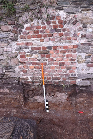
In the area outside the medieval graveyard of St Stephen, natural boulder clay was observed abutting the boundary wall. There was no evidence for a cut in the boulder clay for a wall trench (albeit disturbed by prior insertion of telecom and electricity cables) indicating that the wall was built from the inside, and revetted against the clay. The base of the graveyard boundary wall was 0.74m below the footpath level at the west, and had a stone footing 0.32m wide, 0.12m deep. The base of the wall was level and did not rise with the hill. The doorway ope measures 2.2m high x 1.23m wide (roughly 7’ x 4’) and the doorway jambs continued to the footing. The footing here was 0.63-0.69m below the footpath level. The original door to the graveyard had been blocked by bricks above the level of the modern footpath. Below the brick infill was a loose rubble deposit with some loose bricks, over a heavy deposit of mortar, overlying redeposited natural clay (see photo). There was no evidence for former steps, or a cut indicating the former location of steps, leading down to this door from modern level. The threshold for the modern entrance to the graveyard farther east was 0.3m above the footing.
Elsewhere in Brown’s Lane the foundations of a 19th-century terrace were exposed. Ducting was largely confined to pre-disturbed service lines. Limited works at the north end of Newgate Street showed modern tarmac immediately over weathered shale rock, as was the case at the west side of the southern side of Stephen’s Street. No trace of the New Gate entrance to the walled city survives in the area excavated.