2019:473 - WATERFORD: St Savior's Church (Blackfriars), Waterford
County: Waterford
Site name: WATERFORD: St Savior's Church (Blackfriars)
Sites and Monuments Record No.: WA009-005031
Licence number: E005066
Author: Órla Scully
Author/Organisation Address: 7 Bayview, Tramore, X91 X462
Site type: Historic town
Period/Dating: Multi-period
ITM: E 660867m, N 612576m
Latitude, Longitude (decimal degrees): 52.261517, -7.108360
Under the ministerial Consent C000187 granted to Waterford City & County Council, the interior of the Dominican Friary, known as Blackfriars, was cleared of vegetation and this is now being followed up with some conservation works under the auspices of Waterford Civic Trust and Waterford City & County Council, under the care of Conservation Officer Rose Ryall, with the conservation architect Fintan Duffy of DHB architects, and the author. The works are being carried out by the Waterford & Wexford Educational Training Board’s Traditional Stone Wall Construction Course, under the direction of master mason Tony Jones.
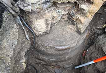
The masons will repair a long-damaged drum column at one side of the block arch which once led to the Lady Chapel of the Friary. The site is within the nave of the 13th-century Dominican Friary of St Saviour, once church of the Blackfriars community. The excavation was carried out for the express purpose of following the drum column down to a point where it was not damaged, so the masons undertaking the conservation works could repair it from that point up. Consequently, only a limited cutting surrounding the damaged column was opened.
The small cutting revealed the plinth of the column which was still intact. The damage to the column evident above ground since at least 1986 was seen to have extended to the upper surface of the underlying column base. The moulded base was itself damaged at its outer northern rim. There were a series of 4 stone layers making up the base which rested on a bed of small stones.
The basal layer was mortar rich, indicating a building level. The silts which build up over this layer contained post-medieval debris, indicating accumulation later than the primary use of the church. The layer of charcoal at the underside of the layer of crushed slates may indicate a fire in the final days of its roofing. The slate debris indicates the collapse of a roof. The silt which built up over the slate layer had elements of demolition debris. There did not appear to be a surviving floor layer. No tiles remained at the levels above the building layer.
The full diameter of the pillar base was calculated to be 0.835m. The column was demonstrably leaning to the south.
It is hoped to keep the cutting open to view, and perhaps conduct further excavation in the future to reveal the base of the opposing column at the west.