2019:666 - FETHARD: Main Street, Tipperary
County: Tipperary
Site name: FETHARD: Main Street
Sites and Monuments Record No.: N/A
Licence number: Unlicensed monitoring
Author: Marion Sutton, Maja Czechak & Seán Shanahan, Shanarc Archaeology Ltd.
Author/Organisation Address: 39A Unit, Hebron Business Park, Hebron Road, Kilkenny
Site type: Town
Period/Dating: Modern (AD 1750-AD 2000)
ITM: E 620585m, N 634996m
Latitude, Longitude (decimal degrees): 52.466016, -7.697058
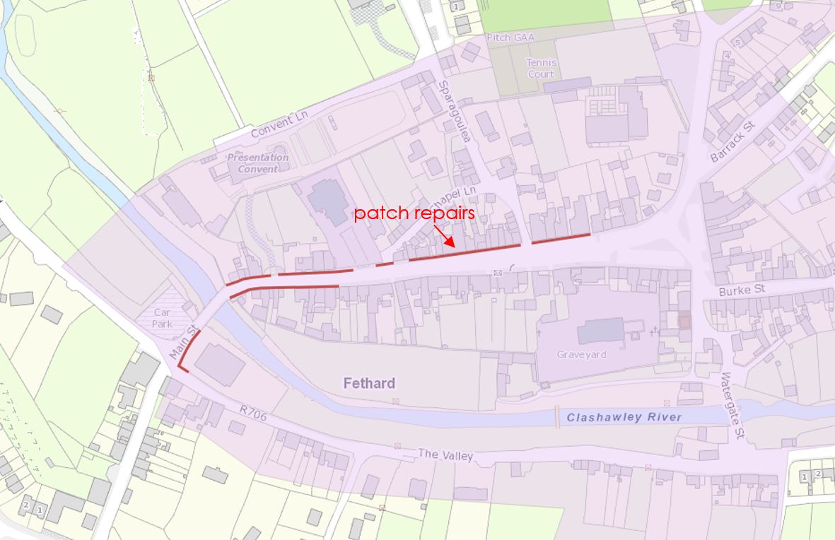
Excavation work related to footpath replacement and patch repairs was carried out by Tipperary County Council on Main Street, Fethard, Co. Tipperary inside the Zone of Archaeological Potential of the historic town (TS070-040). This work was monitored over 9 days between 15 May and 6 June 2019.
The excavation work involved the breaking and removal of existing concrete footpath surfaces and kerbing prior to relaying new, reinforced footpath surfaces at pre-existing levels. Footpath replacement and patch repairs were carried out in several sections, on both sides of Main Street, from the intersection of Main Street, The Valley, Cashel Road and Kerry Street, at the west end of Main Street, to the junction of Rocklow Road and Main Street in the centre of the town. A trench, approximately 82m in length x 0.6m in width x 0.4–1m in depth, was excavated below the footpath on the south side of Main Street between the Holy Trinity Catholic Church and Madam’s Bridge (TS070-040018) for a sub-surface electrical cable duct.
Evidence of the post-medieval form of Main Street, by way of remnant cobble stones and/surfaces, and of post-medieval infrastructure, in the form of stone-capped culverts, was exposed on the north side of Main Street. All identified features remain in-situ beneath the reconstructed footpath.
Evidence of a capped, stone culvert was identified 0.15m below footpath level at the southern side of the current vehicle entrance to the Presentation Convent.
One small patch of in-situ cobbles was exposed immediately beneath the concrete footpath outside the walled and railed entrance to the former parochial house. Cobble stones were laid on brownish-orange clay and small iron nails were recovered between the cobbles during cleaning. The cobble surface did not survive beyond the entrance point to the building, as no further evidence of the surface was revealed below the footpath on either side. The cobble surface was exposed 0.14m below the footpath level, directly overlain by a c.0.09m layer of modern gravels and clay below the concrete. The cobbles indicate that Main Street (or part of) was formerly covered by cobbles.
Evidence of a second capped, stone culvert, containing a metal grill or grate, was identified outside the office building on the west side of the Holy Trinity Catholic Church graveyard. The capping stones lay directly below the concrete footpath surface, which were removed exposing the metal grill and the culvert base and side walls. The culvert measured 0.4m high (inclusive of cap stones); the metal grill measured 0.29m high. Side walls were mortared and built using both rounded and angular stone. The culvert is orientated north-south.
Two limestone slabs were also exposed below the corner pier at the east end of the stone boundary wall fronting Main Street at the Holy Trinity Catholic Church.