2019:854 - CLOONRADOON (1), Roscommon
County: Roscommon
Site name: CLOONRADOON (1)
Sites and Monuments Record No.: N/A
Licence number: E5197
Author: Lydia Cagney and Brigid Melloy, AMS
Author/Organisation Address: Fahy's Road, Kilrush, Clare
Site type: Kiln - brick and Pit
Period/Dating: Post Medieval (AD 1600-AD 1750)
ITM: E 595158m, N 780617m
Latitude, Longitude (decimal degrees): 53.775117, -8.073456
Cloonradoon 1 comprised five post-medieval brick clamp kilns which were excavated in advance of construction of the N5 Ballaghaderreen to Scramoge Road Project in County Roscommon by Archaeological Management Solutions (AMS) for Roscommon County Council (RCC) and Transport Infrastructure Ireland (TII). The site was identified during Stage (i)a Standard Test Excavations carried out by AMS under Ministerial Direction (Direction No. A077, Registration No. E5247; Hardy 2021).
The on-site Stage (iii) Excavation Services at Cloonradoon 1 were undertaken by AMS between 8 July and 2 August 2019.
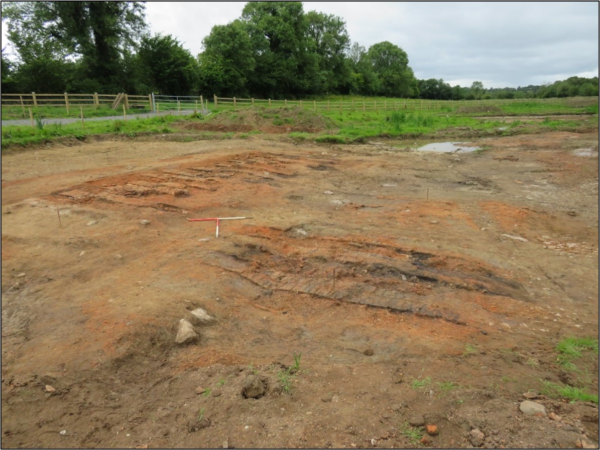
Cloonradoon 1 comprised five post-medieval brick clamp kilns located on the former Strokestown Demesne. Brick Clamp 1 was located in the south of the site and comprised twelve brick benches, aligned north-east/south-west, and a brick kerb defining the southern extent of the clamp. Clamp 2 was located c.4m northeast of Clamp 1 and consisted of four brick benches, aligned north-east/south-west. Clamp 3 was located in the northwest of the site and consisted of five brick benches, aligned north-east/south-west. Clamp 4 was located c.5m southeast of Clamp 3 and consisted of three brick benches, orientated on a north-west/south-east alignment. Clamp 5 was located immediately southeast of Clamp 1 and consisted of five brick benches orientated north-west/south-east and a brick kerb defining the western extent of the clamp.
The brick benches ranged in size from 4.1m long, 0.4m wide, 0.09–0.14m deep to 1.1m long, 0.42m wide, 0.2m deep and comprised one to three courses of bricks approximately 0.2m long, 0.1m wide and 0.06m thick. Between the brick benches several oxidised, charcoal-rich layers were evidenced, which were probably the remnants of the firing material.
Two shallow pits were located in the north of the site. The first pit was located south of Clamp 3 and measured 1.1m long, 0.5m wide and 0.47m deep. It contained a single fill consisting of moderately compact, dark grey silty clay with brick rubble and flecks of charcoal. A second pit was located north of Clamp 3. It measured 1.05m long, 0.95m wide and 0.05–0.1m deep and contained a single fill consisting of loose, dark brownish-grey silty clay, with brick rubble and flecks of charcoal. The relationship between these pits and the brick clamps is currently unknown. The brick clamps were most likely used for construction at the Strokestown Demesne.
Three artefacts were recovered from the site, including a sherd of a possible nineteenth-century glass bottle, an early medieval iron whittle-tanged knife and a stem fragment of a late eighteenth–early nineteenth-century clay tobacco pipe. The glass sherd and the clay tobacco pipe stem were possibly remnants from the brickmakers working on the clamp. The iron knife likely relates to the ringfort/rath located to the north and to the south of the site. Samples of charcoal, brick and animal bone were analysed by the relevant specialists. The charcoal and the animal bone were likely related to the fuel used in the firing process of the clamp.
This report summary was submitted on behalf of its authors.
Reference
Hardy, C. 2021. N5 Ballaghaderreen to Scramoge Road Project Stage (i)a, (i)b, (i)c Test Excavation, Stage (i)m Testing in Felled Forestry and Stage (i)f Townland Boundary Survey. Ministerial Direction No. A077, Registration No. E5070. Unpublished AMS report for TII and RCC.