2019:853 - CARTRONAGOR (1), Roscommon
County: Roscommon
Site name: CARTRONAGOR (1)
Sites and Monuments Record No.: N/A
Licence number: E005075
Author: Gerry Mullins, Breana McCulloch and Kevin Kearney, AMS
Author/Organisation Address: Fahy's Road, Kilrush, Clare
Site type: Enclosure, Pit and Field system
Period/Dating: Bronze Age (2200 BC-801 BC)
ITM: E 583350m, N 787340m
Latitude, Longitude (decimal degrees): 53.835287, -8.252953
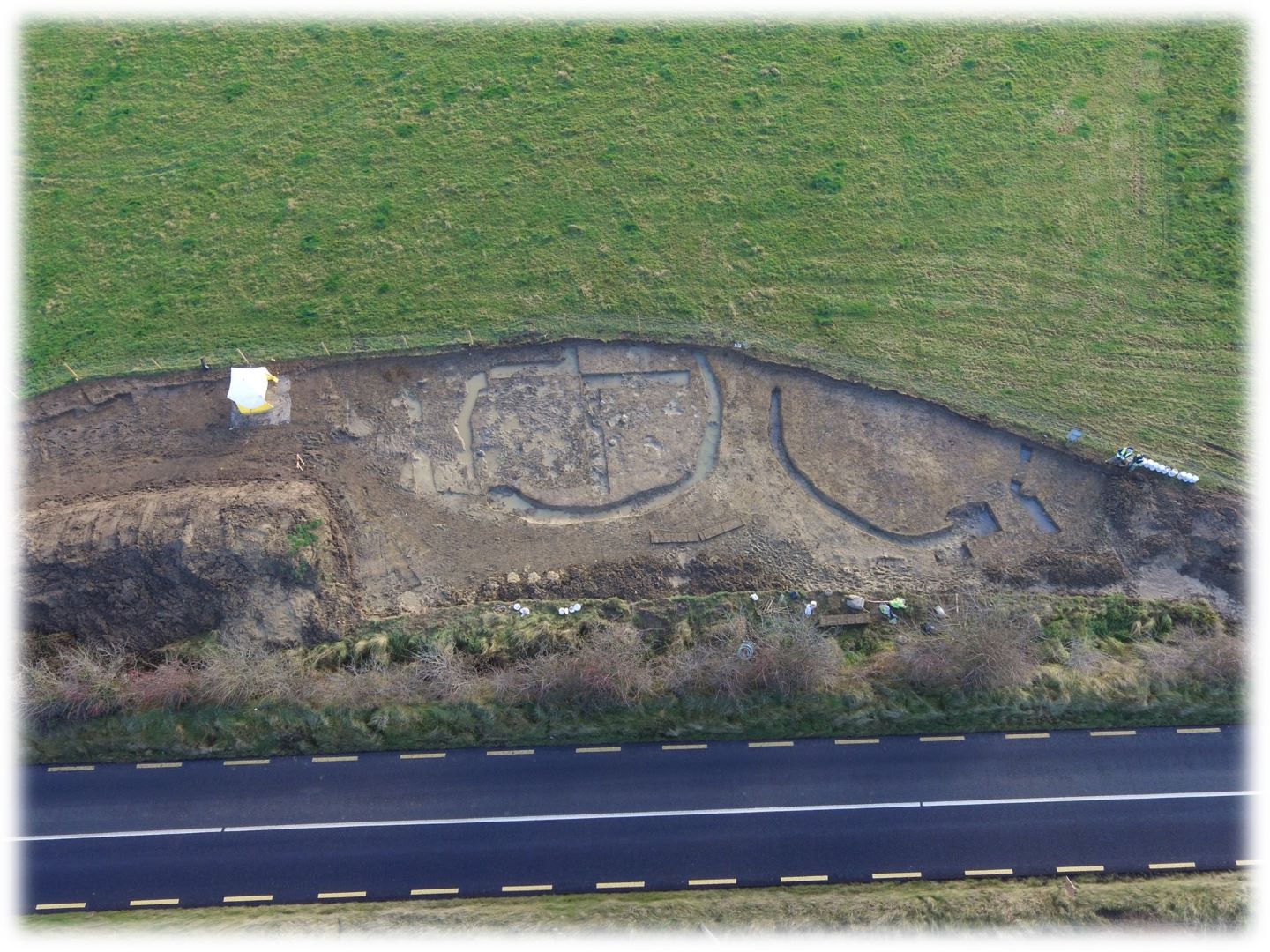
Cartronagor 1 comprised two areas, A and B, excavated in advance of construction of the N5 Ballaghaderreen to Scramoge Road Project in County Roscommon by Archaeological Management Solutions (AMS) for Roscommon County Council (RCC) and Transport Infrastructure Ireland (TII).
A possible moated site was identified c.10m south of the route in LiDAR analysis in advance of these works (Davis 2015). Although subsequent geophysical survey did not find any evidence of this feature (Licence No. 15R0123; Bonsall & Gimson 2015) it did identify several linear features. These were designated Cartronagor 1, Area A. During the Stage (i) Standard Test Excavations (Hardy 2021) adjacent this area, c.120m to the east, two enclosures were identified, and these were included in the excavation of Cartronagor 1 as Area B.
The two enclosures were initially interpreted as ring-ditches (Mullins & McCulloch 2022); however, due to the distinctly domestic nature of the material recovered, they are now interpreted as two small settlement or associated farming enclosures.
The on-site Stage (iii) Excavation Services at Cartronagor 1 were undertaken by AMS between 26 July and 16 August 2019 and 4 November and 5 December 2019.
Area A contained two segments of a field boundary ditch. The excavated sections were 60m long, 3m wide and 0.06–0.08m deep, orientated northwest–southeast and likely to be post-medieval in date.
Area B contained two enclosures located c.2.5m apart, along with a possible pit and a deposit—noted in the baulk section—one large pit, four tree bowls and numerous furrows.
The easternmost enclosure was sub-circular with an internal diameter of c.15m. It consisted of two segments that were separated by a possible entrance in the northeast measuring c.1.3m wide. The larger, western segment (22.5m long by 1.2m wide and 0.45m deep) contained two fills: a basal fill of loose light greyish-brown clayey silt with occasional charcoal inclusions, 0.35m deep, and an upper fill of loose light greyish-yellow silty clay with infrequent charcoal inclusions, 0.25m deep. A sample of blackthorn/cherry charcoal from the basal fill returned a Middle Bronze Age date of 1503–1317 cal. BC (UBA-47776; 3159±34BP) and a sample of pomaceous fruitwood charcoal from the upper fill returned a Middle Bronze Age date of 1503–1297 cal. BC (UBA-47777; 3144±41BP). Unburnt bone of cattle, sheep/goat and pig, in addition to a small quantity of calcined indetermined bone, was recovered from both fills. A jasper chip, two flint and 51 chert flakes, in addition to sherds and crumbs of Middle Bronze Age pottery were also recovered from its fills.
The eastern segment of this enclosure measured 8m by 0.9m in plan, 0.29m deep and contained a single fill of loose mid-yellowish -grey silty clay with infrequent charcoal inclusions. A single fragment of a charred cultivated/wild/bristle oat, a cow premolar, a deciduous premolar of pig, two bones from a medium-sized animal, three from a large-sized animal and ten small pieces of indeterminate burnt bone were recovered from its fill. Two artefacts (a flint and chert flake) were also recovered. The former presence of an outer bank is suggested by a deposit which was recorded in the southern baulk section.
The westernmost enclosure was 14.4m in diameter, 0.85m in width, 0.4m deep and also consisted of two segments; however, this was due to a large modern pit which fully truncated the enclosure. It contained three fills: a basal fill of loose mid-greyish-brown silty clay with moderate pebble inclusions, 0.16m deep; a secondary fill of mid-brownish-yellow silty clay, 0.31m deep; and an upper fill of loose dark brownish-grey sandy silt with occasional pebble inclusions, 0.08m deep. Unburnt and calcined bone from cattle, large and medium-sized mammals, chert and flint flakes and sherds of Middle Bronze Age pottery were recovered from its fills.
The full extent of the site is unknown as both enclosures extended beyond the limit of excavation; therefore, in-situ features associated with the enclosures may be located outside of the Compulsory Purchase Order area.
One of the natural features, a tree bowl (1.26m by 0.57m in plan and 0.05–0.13m deep), revealed twelve finds during both excavation and wet-sieving of the soil samples, including: one Middle Bronze Age pottery body sherd, three Middle Bronze Age pottery crumbs, two flint flakes and six chert flakes.
One-hundred and twenty artefacts, including the jasper chip, flint scraper, chert and flint flakes, and sherds of Middle Bronze Age pottery were recovered during investigations. These will be retained for the national collection. Charcoal from the fills of the eastern enclosure consisted of hazel, ash, oak blackthorn/cherry and pomaceous fruitwood, while a single fragment of a charred cultivated/wild/bristle oat was also recovered from one of its fills.
This report summary was submitted on behalf of its authors.
References
Bonsall, J. & Gimson, H. 2015. Geophysical Survey Report, N5 Ballaghaderreen-Scramoge Road Development. Unpublished report prepared by Earthsound Archaeological Geophysics on behalf of Roscommon County Council.
Davis, S. 2015. N5 Strokestown-Ballaghaderreen corridor: LiDAR Assessment. Unpublished report prepared by UCD School of Archaeology for Roscommon County Council and TII.
Hardy, C. 2021. N5 Ballaghaderreen to Scramoge Road Project Stage (i)a, (i)b, (i)c Test Excavation, Stage (i)m Testing in Felled Forestry and Stage (i)f Townland Boundary Survey. Ministerial Direction No. A077, Registration No. E5070. Unpublished AMS report for TII and RCC.
Mullins, G. & McCulloch, B. 2022. N5 Ballaghaderreen to Scramoge Road Project Stage (iii) Post-excavation Assessment Report: Cartronagor 1, Direction No. A077, Registration No. E5075. Unpublished AMS report for RCC and TII.