2019:403 - MACDERMOT'S ROCK, Rockingham Demesne, Roscommon
County: Roscommon
Site name: MACDERMOT'S ROCK, Rockingham Demesne
Sites and Monuments Record No.: RO006-046----
Licence number: 19E0348
Author: Thomas Finan, Saint Louis University
Author/Organisation Address: Department of History, 3800 Lindell Blvd, Saint Louis University, St. Louis, MO 63108 USA
Site type: Ringfort - cashel
Period/Dating: Early Medieval (AD 400-AD 1099)
ITM: E 584725m, N 804497m
Latitude, Longitude (decimal degrees): 53.989502, -8.232920
The 2019 excavations on MacDermot’s Rock on Lough Key, County Roscommon exposed the remains of a major high status Gaelic lordly settlement dating to the high middle ages as well as evidence for a significant cashel-like fortification predating the high medieval settlement. The 2019 excavations effectively show that the entirety of the island is filled with medieval remains, and these remains are undisturbed by the 19th-century architectural recasting of the island.
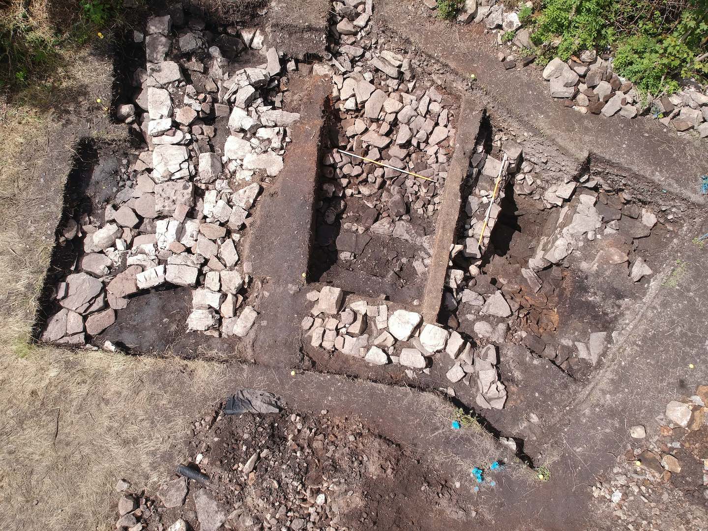
At least three phases of settlement were defined in excavation. An enclosure wall that was 2m wide was identified on top of the base island geology at a depth of 1.5m. No artifacts were recovered with this feature, but an entrance feature 1m wide oriented to the north-north-east was located.
A significant burned context of variable thickness (20-120mm) was delineated across the entire site on top of the Phase I wall. This black, loose silty layer was recovered with a significant amount of butchered animal bone, consisting of cattle, pig, deer, and sheep. A large number of nails were recovered in the burn layer; these nails varied from 40mm to 100mm in length, nearly all with round heads 30mm in diameter. Other iron objects including keys, shears, knives buckles, and possibly mug handles were recovered through excavation and extensive sieving.
The bases of two dry stone buildings had been built on top of the burn layer. The stones ranged in size from 0.25-0.4m in width, and were roughly square with no obvious tooling. The walls of both buildings were under 1m in width. The exact dimensions of each house were indeterminate due to collapse on the one hand and the building wall outside the excavation area on the other, but both appear to be roughly 5m square.
A packed light brown clay floor was found within the walls of Building 1. Artefacts including silver pins, a gaming piece, animal bone, a bone pin, and various iron objects were recovered immediately beneath the clay floor. Twelve pieces of worked deer antler were recovered immediately on top of the floor. Pieces of a single green glazed pottery vessel were recovered from the context immediately above the clay floor.
Building 2 was located to the south of Building 1, with the north wall butt against wall collapse of Building 1. The walls of Building 2 were of similar construction to Building 1, but also showed evidence of mortar. Several iron objects including an iron buckle were found on the interior of the building, but no floor surface was identified.
Modern occupation of the site associated with the historical redesign of the island in the nineteenth century was evidenced by the top 0.1m of soil. Animal bone, transferware china, and one pipe-stem of indeterminate date were recovered from these layers. No features were identified from the nineteenth century.
Additional research is needed on the island to determine the precise relationship between the excavated features and the extant walls on the island. Architecturally the central tower-house no doubt dates to the later medieval era, but its connection to the original cashel wall and the two medieval buildings is unknown.