2019:829 - TRIM: Yellow Steeple Walking Trail, Porch Field, Meath
County: Meath
Site name: TRIM: Yellow Steeple Walking Trail, Porch Field
Sites and Monuments Record No.: ME036-048053, ME036-048011, ME036-048021, ME036-048003, ME036-048054
Licence number: C670, E005100
Author: Niall Roycroft
Author/Organisation Address: c/o Meath County Council
Site type: Historic town
Period/Dating: Multi-period
ITM: E 680639m, N 756700m
Latitude, Longitude (decimal degrees): 53.554019, -6.783015
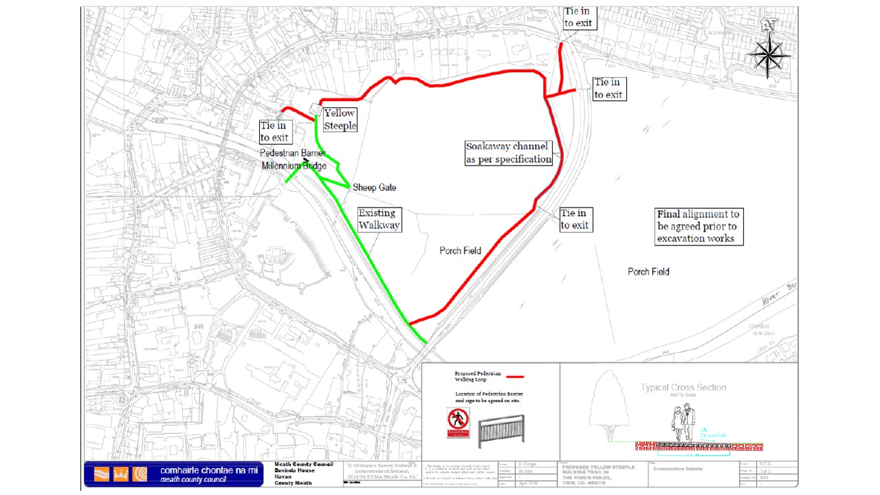
Archaeological monitoring took place of the Trim Yellow Steeple Footpath project approximately 1050m long x 2m wide from the Abbey Lane Gate 680199, 756964 to the Boyne Riverside Walk 680432, 756588 (adjacent to R154) in BlackFriary 2nd Division townland. The works were limited to sod and the upper 0.2-0.25m of agriculturally ploughed topsoil and were monitored from 7–23 October 2019. A total of 51 small finds and 560 general finds (including 323 horseshoe nails and 28 horseshoes—whole or parts) were recovered.
What at first looked like a possible Viking hacksilver finger ingot, located at 680544, 756705, was later considered to be a pewter tripod foot (A. Halpin pers comm). The object weighs 81g. Nearby a lead weight (87g) and a scattering of iron slags (including a small plano-convex furnace bottom) were found.
Topsoil in the area of St Mary’s Abbey / Yellow Steeple lay above a very dark grey brown soil which is full of demolition material but all the larger stones have been removed. The St Mary’s Abbey topsoil showed medieval activity in the form of a broken, iron Type 15 Swallow Tail hunting arrowhead of 15th-16th-century date. 17th–18th-century activity was seen by 5 stone and clay ‘stone-bow’ balls. Both the arrow and the stone bow balls may have been fired from Trim Castle at the Yellow Steeple as target practice (200m).
Alternatively, the stone bow balls (carbine-sized, 15-16mm diameter by 5-6g and musket-sized 20mm diameter—salt glazed—by 11g) could also have been lost here if this location was used by Oliver Cromwell’s troops when they were stationed in Trim; a large square earthwork of potential military form is visible. A lead carbine ball (15mm diameter x 23g) was found at the Lackanash-R154 gate c.330m from the Yellow Steeple potential Cromwell Camp. One archaeological deposit was found adjacent to the Navangate bastion ditch (itself 6–8m wide). The deposit was seen in a very small test pit, 0.5m deep, and consisted of a series of layers possibly corresponding to an outer counterscarp bank covered in agricultural topsoil. A possibly 17th-century winding key was found in the test pit. This denuded counter-scarp is visible on some aerial photos.
The St Mary’s Abbey topsoil adjacent to the Yellow Steeple itself contained a concentration of 17th-19th-century items from woodworking and metalworking workshops that were either lost on site or dumped here from nearby. There were also numerous horseshoes of donkey-type sizes as if the whole zone inside the town walls had been used as paddocks—possibly for horses associated with the nearby Inns on High Street. There was much unstratified animal bone in this area but no evidence for a graveyard. The animal bone presumably came from High Street middens. A few pieces of green-glazed medieval pottery were also found in the
topsoil which had been ploughed and showed 18th-19th-century cultivation ridges.
A George IV half-crown, 1820–30, and two George IV half-pennies, 1820-30 (all very worn), show that the Yellow Steeple area and the rest of the entire Porch Field were under arable farming from the early 19th century onwards. This arable use continued through the 19th century as seen from a penny of 1868. Other 20th-century coins and a 1920s–30 iron, children’s toy cap gun (Kilgore ‘Bigger Bang’) perhaps date the ‘public space’ use of the Yellow Steeple area and the Porch Field in general. Five coins dated 1968–1994 and 11 were post-2002 Euro denomination. There were also screws and nails from the Trim Hay Making Festivals. Some previously noted cropmarks were seen to be modern tent and pony-trekking outlines.
Adjacent to the River Boyne a deposit of probable dredged material was noted, probably from Boyne Drainage works of c.1970. This material contained a wooden box lock of iron but with a silver lock plate (perhaps stolen and dumped in the River).