2019:828 - N2 SLANE APPROACHES PAVEMENT REHABILITATION, Co Meath, Meath
County: Meath
Site name: N2 SLANE APPROACHES PAVEMENT REHABILITATION, Co Meath
Sites and Monuments Record No.: N/A
Licence number: 19E0581
Author: Niall Roycroft
Author/Organisation Address: c/o Meath County Council
Site type: Excavation - miscellaneous
Period/Dating: Modern (AD 1750-AD 2000)
ITM: E 696179m, N 774216m
Latitude, Longitude (decimal degrees): 53.708760, -6.543154
Archaeological monitoring took place of the N2 Slane Approaches Pavement rehabilitation scheme, Slane, Co. Meath (Aug-Dec 2019). The area was N2: 696881 / 774947 to 696382 / 772318: approximately 3.3km and N51: 95822 / 774309 to 696511 / 774081: approximately 475m. The works followed a Notification to National Monuments but, following the discovery of a wooden elm log water pipe and some fixings, the excavation licence 19E0581 was obtained. The centre of the works was the N2/N51 crossroads at the centre of Slane village (the Octagon).
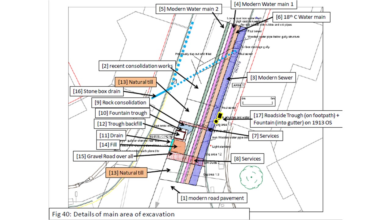
On the N2/Chapel Street arm of the Octagon (at ITM 696179 / 774216) a stone and brick-lined sunken trough and drain were discovered in the middle of the old gravelled road. The trough or possibly fountain base was approx. 1.4m x 1.2m internally with walls 0.35–0.45m thick, visible 0.42m high, with a plastered internal red-brick lining. From the trough a stone-built box drain (min 0.2–0.3m high) led south for approx. 2.2m before being truncated. This trough/fountain was probably part of the original Georgian Village layout since it did not seem to cut through road gravels. During the 19th century, the trough/fountain was dismantled and moved to the east side of the N2 as seen on the 1913 OS map. The trough had been carefully filled and the whole structure covered in road gravels. The trough structure with compacted fill and the outflow drain were preserved in situ during the 2019 works under the new 0.3m thick road surfacing. Nearby, a stone-built box drain ran down the west side of Chapel Street and then diverted south-west to pass beneath the garden of the north-west ‘Four Sister’ House (these gardens are mid-19th-century encroachments into the originally open area of the Octagon). A side feeder box drain 30m to the north may have drained the area to the rear of the stables and nearby Smithy. These drains are 18th-century features of the village.
Near to the trough on the east side, the modern sewer-surface water drain trench had removed any box drain on this side of the road. When a gully was being replaced here, the hole revealed an 18th-century (assumed), 1.5m-long section of elm log tree-trunk water pipe. The log was degraded and broken but had a 4 inch (100mm) diameter central pipe surrounded by 50mm of wood and then another 30mm of cork and bark (total 0.26m diameter). An iron fixing collar found nearby had an internal diameter of 200mm showing the bark was removed at the fixing ends. A cast iron, internal connecting piece, a 100mm diameter cast iron tube c.200mm long with a bulging central ‘olive’ was also observed but could not be retained. Nearby an unstratified ½ inch (12.5mm) internal diameter lead piping approx. 1.15m long probably tapped into the wooden pipe and took water to the fountain(s) and perhaps also to the nearby Georgian houses*. The wooden water main down the east side of Chapel Street (1-2m west from the present kerbline) may still survive in other locations on this street but the loose fixings and broken remains show it has been dug out at the south end.
During the works a repositioned and restored gas light at the Octagon was damaged by a road user. The base was original but severely damaged and part of the lamp shaft appeared to be old but the present head was a modern replacement. This lamp was not a protected structure and will be replaced in situ.
The west side of the N2 north from Slane Bridge to the Octagon was a concrete and stone verge (and a footpath before that) and a series of stone-lined ?flower beds were noted. This verge is now erased as part of the widened N2.
Works in Fennor showed the original N2 road is up to 0.5m below modern make-up and rebuilds.
* This type of pipe is technically known as a ‘quill’

