2019:788 - NAVAN 2030 Services, Road and Footpath Works of 2019 Railway Street to Brew's Hill, Townparks North, Navan's Hill, Meath
County: Meath
Site name: NAVAN 2030 Services, Road and Footpath Works of 2019 Railway Street to Brew's Hill, Townparks North, Navan's Hill
Sites and Monuments Record No.: ME025-044
Licence number: 19E0519
Author: Niall Roycroft
Author/Organisation Address: C/o Meath County Council
Site type: Excavation - miscellaneous
Period/Dating: Multi-period
ITM: E 686736m, N 767709m
Latitude, Longitude (decimal degrees): 53.651955, -6.687964
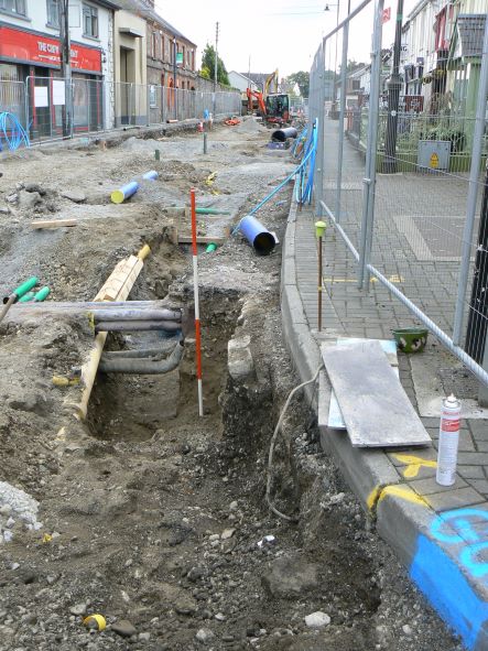
2019 Services works in Railway Street to Brew’s Hill, Navan (ITM: 686736, 767709 to 686816, 767577, Navan Townparks) consisted of two deep trenches along the whole length of Railway Street. The trenches were roughly 1m wide and one was a re-exposure of a recently laid watermain and the other was to lay another watermain. The second new trench was dug down the line of a pair of redundant cast iron watermains, but was generally deeper. The trenches avoided both the existing gas main and the large sewer which also run down the street. At the Brew’s Hill junction an area exposure approx. 20m x 8-9m wide was required due to the need to expose and avoid a mass of in-use and redundant services. For the remainder of Railway Street the road pavement was generally lowered by c.0.5m to create a new surface drainage regime and this lowering reduced to c.0.1m at the Circular Road junction.
Footpath works monitoring focussed on the eastern, ‘Convent’ side of Railway Street when it was reduced in level and rebuilt.
The 2019 works involved a new trench approx. 25m west onto Brew’s Hill southern side and an area approx. 10.5m x 4m was dug at the northern side at the Canon Row junction. A further connection trench 9m x 3m was dug in Trimgate outside the gates of St Mary’s Church to connect to a previously laid service duct from the Railway Street junction.
The works were archaeological monitored for Meath County Council.
Phase 1: Natural strata
The hill on which Navan is built consists of post-glacial yellow-brown silty-sands layered with grits and gravels. Exposures of sands was seen in Railway Street, Brew’s Hill and on Trimgate Street.
Phase 2: Quarrying
Five separate, backfilled quarry pits (each c.3m-4m long) were seen across Railway Street and another was seen in Trimgate Street. Three of the Railway Street quarries were visible beneath modern services, so the date of their initial excavation is not clear.
However, two further Railway Street quarries were clearly visible beneath gravel road surfaces which had been laid elsewhere directly onto natural sands. Previous excavations in Canon Row have dated a considerable number of quarry pits to the later medieval period and it is reasonable to assume most of the Railway Street and the Trimgate pits are medieval or post-medieval in date, pre-dating the construction of Railway Street. All the pits contained similar, clean backfills of mixed, heavy mid-brown silty clays with many gravels and cobbles. No finds were recovered.
Phase 3: Roads
Remains of gravel road surfaces and/or cobbled gutters were seen in eight deposits on Railway Street and in three locations on Brews Hill, but not in the small Trimgate Street trench outside St Mary’s Church gates. In all cases where they were visible, the road(s) of gravel up to 0.2m thick had been built directly on natural sands or the backfilled quarry pits. This means the area had been cleared of any made ground such as field topsoil or rubbish thrown out from the town before the road was built.
19E0519 ext. for 2019 RAILWAY Street Monitoring 3
Historical records of nearby Canon Row show that this area was developed from the 17th century. However, Railway Street (which was originally called Chapel Lane to go with the St Mary’s Chapel–Convent) was probably developed in the 18th century as an extra-mural suburb of Navan. Although the west side of Railway Street was rebuilt and set back behind front ‘gardens’ in the 19th century, the original Railway Street road is probably roughly the same width today as when it was first built. Later, perhaps around 1800, Railway Street became a ‘bypass’ of Navan joining an upgraded or new road running to Trim. This route was a new alternative to the original Trim Road that ran straight from Trimgate Street up Brew’s Hill (and then turned south past the area of the present hospital).
Photographs of 19th-century Navan show that all roads were surfaced with gravel and that they had gravelled or set-built, cobbled gutters. Gravel roads are very hard wearing and only two or so general road levels with a combined depth of 0.15–0.2m deep were visible below the present Railway Street tarmac. Three small exposures of previous roadside gutters seemed to include soakaway drainage to an underlying sand-filled, unlined roadside ditch. This ditch had blurred the edge of the road gravels due to water-staining. No evidence for any buildings or drains were seen.
Phase 4: Modern road surfaces and services
Modern road surfaces and services were seen throughout the works.