2019:734 - DOWTH: Dowth Hall, Meath
County: Meath
Site name: DOWTH: Dowth Hall
Sites and Monuments Record No.: N/A
Licence number: 17E0242
Author: Clíodhna Ní Lionáin
Author/Organisation Address: Devenish, Dowth Hall, Co. Meath
Site type: Megalithic tomb - passage tomb
Period/Dating: Prehistoric (12700 BC-AD 400)
ITM: E 702979m, N 773984m
Latitude, Longitude (decimal degrees): 53.705381, -6.440259
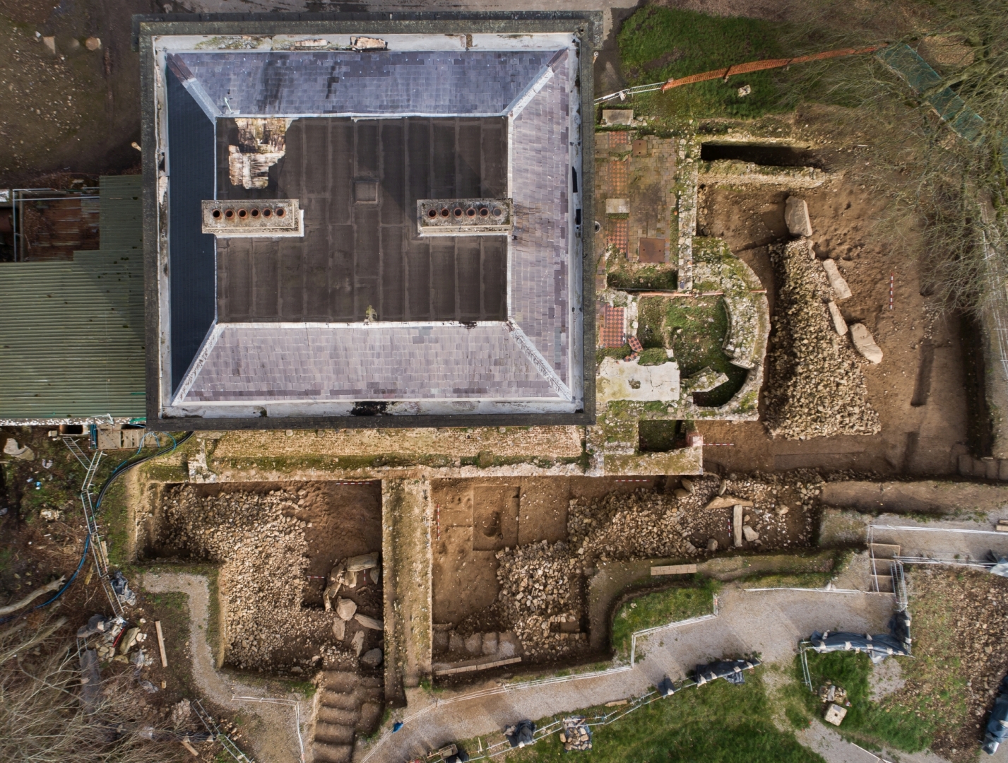
An excavation programme (May 2018—February 2019) was undertaken on the remains of a large passage tomb (c.40m diameter) to the west (Area 1), south-west (Area 2), and south (Area 3) of Dowth Hall. The monument’s surviving remains include two disturbed megalithic chambers, a cairn, and part of a kerb. Both chambers are in the western part of the cairn, c.16.7m apart. The northern chamber (Tomb 1) is a stalled chamber, while the southern chamber (Tomb 2) has a side chamber. Megalithic art is present in both, as well as on three kerbstones. The passage tomb was significantly damaged in the modern period (18th -19th centuries) but was possibly partially demolished prior to this.
Tomb 1: The northern chamber (Area 1) was partially excavated, revealing twelve structural stones (7 in situ orthostats, 2 collapsed roofstones, 2 collapsed orthostats, a collapsed possible lintel) spread over an area of 6.2m (west-south-west/east-north-east) x 3.9m (north-south). The in situ stones formed three stalls, located to the north (Stall C), north-east (Stall B), and east (Stall A) of the central chamber area. During excavation of Stalls A and C, and the central chamber, original deposits were recorded, including pockets of cremated bone, human mandible fragments, and 131 sandstone concretions within, and close to, Stall A. Stall B has not been fully excavated. The collapse of the structural stones to the west of the extant stalls predates the construction of the house, and appears to have been deliberate, as indicated by the careful treatment of human remains in the infill material, as well as the placement of a mandible fragment on one of the collapsed orthostats.
Tomb 2: The southern chamber (Area 2) has a different floor plan (4.5m south-west/north-east x 5.2m), with an eastern side chamber. Ten structural stones were recorded, six of which are in situ. Like the northern chamber, most are greywacke, except for a large possible capstone. Corbelling (3-4 courses) was recorded along the northern extent of the main chamber. Part of the side chamber was excavated, while most of the central chamber infill was left in place. The side chamber is formed by two orthostats to the north and south, and a collapsed orthostat to the east. A foundation trench was excavated for the side chamber, prior to the erection of the orthostats. This cut was lined with buried grass sod layers that extended under the entire cairn.
Cairn: The covering mound was predominantly of stone. The presence of cairn material immediately behind the in situ kerbstones suggests that the original design may not have included a mantle of sod. The cairn was extended in its south-eastern quardrant. This modification is relatively limited and may represent a course correction during construction rather than a later extension. A layer of quartz pebbles was deposited on the cairn in this area.
Kerb: Six kerbstones were recorded along the southern perimeter of the cairn (Area 3). Three were in situ, while two had moved/fallen to the south. The most easterly kerbstone was incorporated into the wall of a modern structure. The other kerbstones appear to originally have formed a straight north-east/south-west line.
Cairn Slippage: There were multiple episodes of cairn slippage immediately south of the monument. The first three episodes took place prior to the deposition of Beaker pottery in front of the kerb. At some point after this, a cremation burial pit was dug into a later cairn slippage layer, which was also cut by a shallow ditch further south, possibly representing an attempt to redefine the monument’s perimeter.
Medieval Activity: Around 7m north-west of the southern chamber, a probable souterrain was cut into the cairn. This rectangular drystone structure (2.6m north-north-west/south-south-east x 1.5m west-south-west/east-north-east x 0.48m deep) was constructed using large (0.25-0.38m), flat stones, with 3-4 courses surviving (0.5m high). A compact soil layer was deposited directly above the cairn to provide a compact floor, which slopes downward to a step at its southern end. If this is a souterrain, it would suggest that the cairn was relatively intact during the medieval period.
Satellite Tombs: During the excavation programme, two possible satellite tombs were identified immediately north (Area 4) and north-west (Area 5) of Dowth Hall. Two orthostats had previously been recorded in Area 5. Following cleaning, an additional two orthostats, a kerbstone, and two ex situ stones were found. The four orthostats appear to form the western end of a rectangular chamber. The location of the kerbstone suggests that this was probably a small (c.12-13m diameter) satellite tomb (Tomb 3). Most of the eastern part of Tomb 3 has been removed by the 19th century additions to Dowth Hall.
The remains of another possible satellite tomb, consisting of two displaced kerbstones and possible cairn material, were recorded during testing of a raised area c.8m north of Dowth Hall. One of the kerbstones was fully collapsed, while the kerbstone east of it, and slightly overlapping it, was only partially collapsed. The presence of stone material to the north and south of the kerb, and the small size of the excavation area, meant that initially it was not clear if the kerbstones had fallen back to the south or forward to the north. However, the position of the fully flat kerbstone partially under the displaced kerbstone suggests that the latter theory is correct.
Preliminary Conclusions: The excavation programme has identified the presence of a large focal passage tomb under Dowth Hall, and two smaller satellite tombs to the north and north-west. In addition to the recorded mounds (ME020-12—-, ME020-013—), these newly identified monuments form part of a previously unknown passage tomb cemetery. Significant modern damage occurred when Dowth Hall was built, compounded by subsequent building interventions. However, it appears that the Dowth Hall passage tomb was already damaged when the modern builders first encountered it. Radiocarbon dating is required to determine when this earlier damage might have occurred. Post-excavation analysis is ongoing.